Bungudu
Bungudu (or Bungundu) is a Local Government Area in Zamfara State, Nigeria. Its headquarters is in the town of Bungudu at12°16′00″N 6°33′24″E.
Bungudu | |
|---|---|
LGA and town | |
 Bungudu Location in Nigeria | |
| Coordinates: 12°09′N 6°30′E | |
| Country | |
| State | Zamfara State |
| Area | |
| • Total | 2,293 km2 (885 sq mi) |
| Population (2006 census) | |
| • Total | 257,917 |
| Time zone | UTC+1 (WAT) |
| 3-digit postal code prefix | 881 |
| ISO 3166 code | NG.ZA.BD |
It has an area of 2,293 km2 and a population of 257,917 at the 2006 census.
The postal code of the area is 881.[1]
Climate
The wet season is oppressive, mostly cloudy, with a hot year-round temperature ranging from 59°F to 101°F, with occasional drops below or above 105°F.[2][3]
Temperature
The temperature is rising in Bungudu due to climate change, and this warming trend is pointing to a change in the direction of a more resilient and sustainable climate.[4]
References
- "Post Offices- with map of LGA". NIPOST. Archived from the original on 2009-10-07. Retrieved 2009-10-20.
- "Bungudu Climate, Weather By Month, Average Temperature (Nigeria) - Weather Spark". weatherspark.com. Retrieved 2023-09-01.
- "Bungudu, Zamfara, Nigeria - City, Town and Village of the world". en.db-city.com. Retrieved 2023-09-01.
- "Climate Change Bungudu". meteoblue. Retrieved 2023-10-19.
State capital: Gusau | ||
| Local Government Areas | 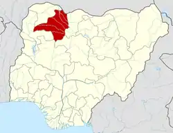 | |
This article is issued from Wikipedia. The text is licensed under Creative Commons - Attribution - Sharealike. Additional terms may apply for the media files.