Antsirabe II District
Antsirabe II is a rural district in Vakinankaratra Region, Madagascar. The district surrounds the urban district and city of Antsirabe. It also borders the district of Faratsiho to the north, Antanifotsy to the east and Betafo to the west, in addition to the region of Antanifotsy to the south. The district covers a total area of 2,471.31 km2, with a population estimated at 406,353 in 2013.[1]
Antsirabe II | |
|---|---|
District | |
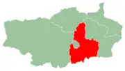 Location of the district within the region of Vakinankaratra. | |
| Coordinates: 19°52′8.184″S 47°8′54.384″E | |
| Country | |
| Region | Vakinankaratra |
| Area | |
| • Total | 2,471.31 km2 (954.18 sq mi) |
| Population (2013) | |
| • Total | 406,353 |
| • Density | 160/km2 (430/sq mi) |
Communes
The district is further divided into 18 communes:
References
- Institut National de la Statistique, Anananarivo.
Capital: Antsirabe | ||
| Ambatolampy (19) |  | |
| Antanifotsy (14) | ||
| Antsirabe I (1) | ||
| Antsirabe II (20) | ||
| Betafo (18) | ||
| Faratsiho (9) | ||
| Mandoto (9) | ||
7 districts; 89 communes | ||
This article is issued from Wikipedia. The text is licensed under Creative Commons - Attribution - Sharealike. Additional terms may apply for the media files.