Faratsiho District
Faratsiho is a town in Vakinankaratra Region, Madagascar. It is the capitol of the district of Faratsiho[3] The district covers an area of 2,015 km2, with a total population estimated at 222,922 in 2018. The seat of the district administration is the town of Faratsiho.
Faratsiho (district) | |
|---|---|
 Faratsiho (district) Location in Madagascar | |
| Coordinates: 19°24′00″S 46°57′00″E | |
| Country | |
| Region | Vakinankaratra |
| District | Faratsiho District |
| Area | |
| • Total | 2,015 km2 (778 sq mi) |
| Population (2018)[2] | |
| • Total | 237,162 |
| Postal code | 114 |
| Climate | Cwb |
Communes
The district is further divided into nine communes:
Roads
The district and the town of Faratsiho is crossed by the National road 43 (Analavory-Antsirabe).
Rivers
3 rivers cross the municipality of Faratsiho: Kitsamby, Sahomby and the Mahasetroka river.[4] The Sahasarotra river crosses this district from East to West.[5]
Nature
- Faratsiho Natural Park
References
Capital: Antsirabe | ||
| Ambatolampy (19) | 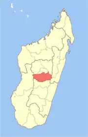 | |
| Antanifotsy (14) | ||
| Antsirabe I (1) | ||
| Antsirabe II (20) | ||
| Betafo (18) | ||
| Faratsiho (9) | ||
| Mandoto (9) | ||
7 districts; 89 communes | ||
This article is issued from Wikipedia. The text is licensed under Creative Commons - Attribution - Sharealike. Additional terms may apply for the media files.