Arbor Hill, Iowa
Arbor Hill is an unincorporated community or ghost town[1] in Adair County, Iowa, United States.[2]
Arbor Hill, Iowa | |
|---|---|
 Arbor Hill, Iowa Location of Arbor Hill, Iowa  Arbor Hill, Iowa Arbor Hill, Iowa (the United States) | |
| Coordinates: 41°22′00″N 94°19′06″W | |
| Country | |
| State | |
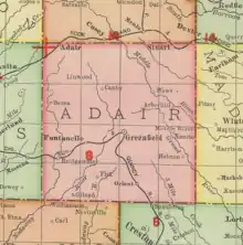
| County | Adair County |
| Elevation | 344 m (1,129 ft) |
| Time zone | UTC-6 (Central (CST)) |
| • Summer (DST) | UTC-5 (CDT) |
| Area code | 641 |
History
A post office was established at Arbor Hill in 1857, the name was changed to Arborhill in 1895, and the post office closed in 1907.[4][5]
Arbor Hill's population was 58 in 1902.[6] The community was once home to the Arbor Hill Co-Operative Creamery Company,[7] a blacksmith shop,[1] and a general store;[1] the Port Union Mill dam was located one half mile west of Arbor Hill, on the Middle River.[8] The community (at that time known as Arborhill) was the site of the Seventh Annual Old Settlers and Old Soldiers Reunion, held on August 12, 13, and 14, 1908.[9]
The Methodist church in Greenfield, constructed in 1877, was built from lumber cut near Arbor Hill.[10]
Arborhill's population was 68 in 1924.[11] The 1930 plat book of Adair County shows Arbor Hill platted in the southeast quadrant of Section 20 of Harrison Township, with the community covering one quarter square mile.[12]
Arbor Hill's population was 12 in 1940.[13]
In 2018, the Arbor Hill Wind Farm project began, with the MidAmerican Energy Company building enough wind turbines in Arbor Hill and nearby Orient to power 230,000 homes.[14]
See also
References
- "Arbor Hill, Iowa". Iowa Ghost Towns. Retrieved May 21, 2021.
- U.S. Geological Survey Geographic Names Information System: Arbor Hill, Iowa
- "US Gazetteer files: 2010, 2000, and 1990". United States Census Bureau. February 12, 2011. Retrieved April 23, 2011.
- Kilburn, Lucian Moody (1915). History of Adair County, Iowa, and Its People. Pioneer Publishing Company. p. 162.
- "Post Offices". Jim Forte Postal History.
- Cram's Modern Atlas: The New Unrivaled New Census Edition. J. R. Gray & Company. 1902. pp. 203–207.
- 1904 Complete Creamery Directory of the United States. National Dairy Union. 1904. p. 64.
- Condra, George Evert; Jerry Eli Upp (1933). The Middle River Traverse of Iowa. p. 23.
- "The Des Moines Register from Des Moines, Iowa on August 3, 1908 · Page 7". Retrieved May 22, 2021.
- Kilburn, Lucian M. (1915). History of Adair County, Iowa, and its People (vol 1). Pioneer Publishing Company. Retrieved May 22, 2021.
- Premier Atlas of the World: Containing Maps of All Countries of the World, with the Most Recent Boundary Decisions, and Maps of All the States,territories, and Possessions of the United States with Population Figures from the Latest Official Census Reports, Also Data of Interest Concerning International and Domestic Political Questions. Rand McNally & Company. 1925. p. 188.
- Plat book of Adair County, Iowa. 1930. Retrieved May 22, 2021.
- The Attorneys List. United States Fidelity and Guaranty Company, Attorney List Department. 1940. p. 292.
- Robinson, Tom (June 22, 2018). "Construction has started on the Arbor Hill Wind Farm Project in Adair County". Retrieved May 22, 2021.
External links
Municipalities and communities of Adair County, Iowa, United States | ||
|---|---|---|
| Cities | Map of Iowa highlighting Adair County | |
| Townships | ||
| Unincorporated communities | ||
| Footnotes | ‡This populated place also has portions in an adjacent county or counties | |