Berea, Iowa
Berea was an unincorporated community in Eureka Township, Adair County, Iowa, United States.[1]
Berea, Iowa | |
|---|---|
 Berea, Iowa | |
| Coordinates: 41°22′27″N 94°40′49″W | |
| Country | United States |
| State | Iowa |
| County | Adair |
| Elevation | 1,306 ft (398 m) |
| Time zone | UTC-6 (Central (CST)) |
| • Summer (DST) | UTC-5 (CDT) |
| Area code | 641 |
| GNIS feature ID | 464460[1] |
History
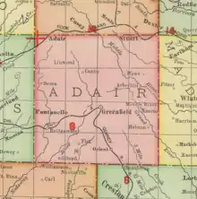
Berea was founded along the banks of the Middle Nodaway River;[2] it was named after the Ancient Greek city of Berea.[3] The community was founded by Ned Brown and Alexander Broadfoot, who were early settlers, and its peak population was around 100 residents.[4]
A post office called Berea was established in 1894, and remained in operation until 1908.[5] In 1905, the community was reported to have a population of 40, with a general store, a pharmacist, a creamery, a blacksmith and a wagonmaker.[6] The Berea Store was built in June 1909, replacing an earlier store which had been destroyed by fire.[7]
In 1915, Berea was described as a village, with the Berea Horse Company being a noted business, owned by brothers Isaac Brown and A.R. Brown.[8] At that time, Berea had a town band which performed at community events.[9] Around that time, Berea's population was estimated at 50 residents.[10]
The Berea Gospel Hall was built in 1929.[4]
The Rock Island Railroad passed through nearby Anita and Adair, and it was for this reason that Berea began to decline.[4] A school still operated at Berea in the 1930s,[11] but most other services had closed by this time. In 1936, the Berea School closed due to lack of pupils, and by the 1940s, the community was called a "ghost village".[4] By that time, Berea had only a general store, the closed school, and the Berea Gospel Hall.[4]
The Berea Store was purchased by the Arnold family in 1950.[12]
Berea still appeared on state maps as late as 1960.[13]
References
- U.S. Geological Survey Geographic Names Information System: Berea, Iowa
- Plat Book of Adair County, Iowa. Mid-West Map Publishers. 1951.
- Joseph Silas Diller (1902). Topographic Development of the Klamath Mountains. U.S. Government Printing Office. p. 41.
- Cleaver, Geraldine (January 20, 1944). "Did You Know... Or Do You Remember?" (PDF). Anita Tribune.
- "Post Offices". Jim Forte Postal History. Retrieved January 11, 2017.
- Polk's Iowa State Gazetteer and Business Directory 1905-1906. Vol. XIII (28th ed.). Des Moines; Chicago; Detroit: R. L. Polk & Co. 1905. p. 205. Retrieved May 21, 2021.
- "Anita Remembers: Looking Back in the Tribune Files". The Anita Tribune. May 28, 1959. p. 2.
- Kilburn, Lucian Moody (1915). History of Adair County, Iowa, and Its People. Pioneer publishing Company. ISBN 978-1-58103-412-7.
- "Celebration". The Anita Record. August 31, 1916. p. 5.
- Iowa State Gazetteer and Business Directory. R.L. Polk & Company. 1912.
- Plat Book of Adair County, Iowa. 1930.
- "Mr. and Mrs. Arnold Buy Berea Store". The Anita Tribune. February 16, 1950.
- "Iowa". World Book Encyclopedia. Vol. I. 1960. p. 304 Political Map.
Municipalities and communities of Adair County, Iowa, United States | ||
|---|---|---|
| Cities | Map of Iowa highlighting Adair County | |
| Townships | ||
| Unincorporated communities | ||
| Footnotes | ‡This populated place also has portions in an adjacent county or counties | |