Archway tube station
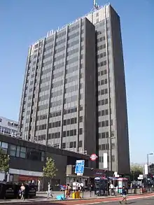
Archway is a London Underground station at the intersection of Holloway Road, Highgate Hill, Junction Road and Archway Road in Archway, north London, directly underneath the Vantage Point building. It is on the High Barnet branch of the Northern line, between Highgate and Tufnell Park stations, in Zones 2 and 3.[12]
| Archway | |
|---|---|
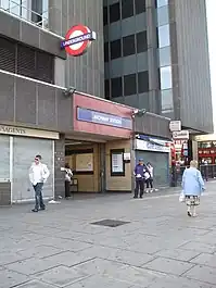
 Main entrance on Junction Road | |
 Archway Location of Archway in Greater London | |
| Location | Archway |
| Local authority | London Borough of Islington |
| Managed by | London Underground |
| Station code | ACY[1] |
| Number of platforms | 2 |
| Fare zone | 2 and 3 |
| OSI | Upper Holloway |
| London Underground annual entry and exit | |
| 2018 | |
| 2019 | |
| 2020 | |
| 2021 | |
| 2022 | |
| Railway companies | |
| Original company | Charing Cross, Euston and Hampstead Railway |
| Key dates | |
| 22 June 1907 | Opened as Highgate; terminus of line |
| 11 June 1939 | Renamed Archway (Highgate) |
| 3 July 1939 | Line extended to East Finchley |
| 19 January 1941 | Renamed Highgate (Archway) |
| December 1947 | Renamed Archway |
| Other information | |
| External links | |
| WGS84 | 51.56556°N 0.13500°W |
Location

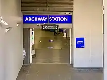
When constructed, the area was simply the northern end of Holloway Road and had no specific name but, in the hope of attracting patronage, the terminus was originally named Highgate after the village up the hill. At the time of the station's construction the first cable tramway in Europe operated non-stop up Highgate Hill to the village from outside the Archway Tavern,[13] and this name was also considered for the station. The main station entrance now lies beneath Archway Tower (now renamed Vantage Point) on Junction Road while the side entrance is on Highgate Hill.
History

The Leslie Green designed station opened on 22 June 1907, under the name Highgate[14][15][16] faced in Green's standard ox-blood glazed brick.[17] It was opened as one of the northern terminals of what was then the Charing Cross, Euston & Hampstead Railway (CCE&HR).[14]
The station was renamed Archway (Highgate) on 11 June 1939[15][16] (after the nearby road bridge over the deep cutting containing Archway Road). On 3 July 1939, the line was extended to the Great Northern Railway's station at Highgate and East Finchley station as part of the New Works Programme.[14][18] The station was renamed Highgate (Archway) on 19 January 1941,[16] before becoming just Archway in December 1947[15][16] with the Highgate name being reassigned to the new station constructed beneath the London and North Eastern Railway (LNER) high-level station of the same name.
On 2 June 2006, a train derailed while entering the reversing siding at the station.[19]
Design
In 1930 the station was upgraded with escalators[20] to replace the original lifts and the secondary entrance was replaced with a modern design by Charles Holden,[17] virtually identical to the one he built at the same time at Hammersmith. Holden's station was replaced in the 1970s.[17]
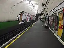
The platform walls once featured the distinctive and elegantly simple tiling schemes used by Holden on the underground stations constructed at this time. Cream tiles were used throughout with the station name band formed of letter shaped tiles inset into a background of cream tiles incised to accept the lettering. Similar tiling schemes can be seen at the neighbouring Highgate station, as well as at Bethnal Green and the stations on the tunnelled section of the Hainault branch of the Central line (for example Gants Hill). All were built in the late 1930s/early 1940s. The tiles at Archway were replaced several years ago during retiling works.
As of 2015, the station has escalators descending to the platforms.[20] Alternatively, passengers can use the 113 steps to get down to the platforms.[21]
Crossover and siding

When the original section of the Northern Line from Charing Cross to Golders Green and Archway (then Highgate) was opened in 1907, the terminus at Archway was provided with a scissors crossover just south of the station and the running lines beyond the north end of the platforms continued as separate dead-end sidings.[22] When the line was extended to Highgate and East Finchley in 1939, the 'northbound' siding was extended as the northbound road while the 'southbound' siding was retained as a dead-end siding, extended at the north end with the new southbound line from Highgate joining it just before the southbound platform and a new connection from the northbound line to the siding, thus turning the old 'southbound' siding into a central reversing siding.[22] The crossover south of the station was subsequently converted to a single trailing crossover but was decommissioned on 15 October 1967, when Archway was converted to programme-machine control from Cobourg Street. The signal box closed on 25 June 1961 when Archway became remote-controlled.[note 1][22]
The enlarged crossover tunnel remains although cable runs extend down its centre between the two tracks for most of its length.[22][note 2] The layout of the platforms and the underground passenger areas still reflect the station's former role as a terminus.
Services
Northern line trains generally operate between Morden or Kennington to Edgware, High Barnet or Mill Hill East via the Charing Cross or the Bank branch.[12] Occasionally and during disruptions or engineering works, trains can terminate at Archway. Train frequencies vary throughout the day, but generally operate every 3–7 minutes between 05:58 and 00:19 in both directions.[23][24]
Connections
- London Buses routes 4, 17, 41, 43, 134, 143, 210, 234, 263, 390, C11, W5 and night routes N20, N41 and N271 serve the station.[25]
- London Underground maps and maps in London Overground trains show the station as 450m from Upper Holloway station on the Gospel Oak to Barking line. Interchange within twenty minutes is allowed between the two stations.[26]
Notes and references
Notes
- It was situated at the south end of the southbound platform and is now a relay room.[22]
- Also of note is a surviving limit of shunt board for 7-car trains, a square white enamel plate with a black 7, on the right-hand tunnel wall of the southbound road south of the crossover that trains pulled up to in order to reverse northwards.[22]
References
- "Station Codes" (PDF). Transport for London. Retrieved 10 October 2021.
- "Out-of-Station Interchanges" (Microsoft Excel). Transport for London. 2 January 2016. Retrieved 28 August 2016.
- "Station Usage Data" (CSV). Usage Statistics for London Stations, 2018. Transport for London. 23 September 2020. Archived from the original on 14 January 2023. Retrieved 11 October 2023.
- "Station Usage Data" (XLSX). Usage Statistics for London Stations, 2019. Transport for London. 23 September 2020. Archived from the original on 9 November 2020. Retrieved 9 November 2020.
- "Station Usage Data" (XLSX). Usage Statistics for London Stations, 2020. Transport for London. 16 April 2021. Retrieved 1 January 2022.
- "Station Usage Data" (XLSX). Usage Statistics for London Stations, 2021. Transport for London. 12 July 2022. Retrieved 7 September 2022.
- "Station Usage Data" (XLSX). Usage Statistics for London Stations, 2022. Transport for London. 4 October 2023. Retrieved 10 October 2023.
- "Station Codes" (PDF). Transport for London. Retrieved 10 October 2021.
- "Station Codes" (PDF). Transport for London. Retrieved 10 October 2021.
- "Station Codes" (PDF). Transport for London. Retrieved 10 October 2021.
- "Station Codes" (PDF). Transport for London. Retrieved 10 October 2021.
- Standard Tube Map (PDF) (Map). Not to scale. Transport for London. November 2022. Archived (PDF) from the original on 7 November 2022. Retrieved 12 November 2022.
- Taylor, Sheila (2001). The Moving Metropolis. London: Calmann and King. p. 82. ISBN 1-85669-241-8.
- Feather, Clive. "Northern line". Clive's Underground Line Guides. Archived from the original on 11 February 2015. Retrieved 25 April 2015.
- Rose, Douglas (December 2007) [1980]. The London Underground: A Diagrammatic History (8th ed.). Harrow Weald: Capital Transport. ISBN 978-1-85414-315-0.
- Butt, R.V.J. (1995). The Directory of Railway Stations. Yeovil: Patrick Stephens Ltd. pp. 17, 120. ISBN 1-85260-508-1. R508.
- "Underground Journeys: Highgate". Royal Institute of British Architects. Archived from the original on 13 September 2012. Retrieved 20 February 2011.
- "100 Years of the Hampstead Tube" (PDF). 11 September 2007. p. 5. Archived from the original (PDF) on 19 July 2013. Retrieved 1 April 2015.
- "Derailment at Archway". Rail Accident Investigation Branch. 10 December 2014. Archived from the original on 24 October 2015. Retrieved 14 November 2021.
- Feather, Clive. "Vertical Transport". Clive's Underground Line Guides. Archived from the original on 7 October 2014. Retrieved 25 April 2015.
- "Tube Facts – Tube Stations with steps". Archived from the original on 22 February 2017. Retrieved 1 April 2015.
- Ragga, John. "Archway". London Underground Technical – Northern Line Disused Features. Archived from the original on 14 February 2014. Retrieved 25 April 2015.
- "Northern line timetable: From Archway Underground Station to Highgate Underground Station". Transport for London. Retrieved 1 April 2015.
- "Northern line timetable: From Archway Underground Station to Tufnell Park Underground Station". Transport for London. Retrieved 1 April 2015.
- "Buses from Archway" (PDF). TfL. 4 February 2023. Retrieved 5 February 2023.
- "Out-of-Station Interchanges" (Microsoft Excel). Transport for London. 2 January 2016. Retrieved 28 August 2016./
External links
- London Transport Museum Photographic Archive
- Archway station on Multimap
- Design drawing by Charles Holden and photograph, 1930s from Royal Institute of British Architects
| Preceding station | Following station | |||
|---|---|---|---|---|
| Highgate towards High Barnet or Mill Hill East |
Northern line High Barnet branch |
Tufnell Park | ||