Ayros-Arbouix
Ayros-Arbouix (French pronunciation: [aiʁɔs aʁbuiks]; Occitan: Airòs e Arboish) is a commune in the Hautes-Pyrénées department in the Occitanie region of south-western France.
Ayros-Arbouix | |
|---|---|
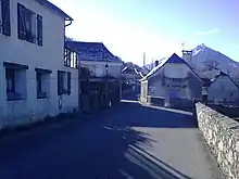
 View of the Mountains from Arbouix | |
.svg.png.webp) Coat of arms | |
Location of Ayros-Arbouix | |
 Ayros-Arbouix  Ayros-Arbouix | |
| Coordinates: 43°00′20″N 0°03′52″W | |
| Country | France |
| Region | Occitania |
| Department | Hautes-Pyrénées |
| Arrondissement | Argelès-Gazost |
| Canton | La Vallée des Gaves |
| Intercommunality | CC Pyrénées Vallées des Gaves |
| Government | |
| • Mayor (2020–2026) | Régis Baudiffier[1] |
| Area 1 | 2.72 km2 (1.05 sq mi) |
| Population | 344 |
| • Density | 130/km2 (330/sq mi) |
| Time zone | UTC+01:00 (CET) |
| • Summer (DST) | UTC+02:00 (CEST) |
| INSEE/Postal code | 65055 /65400 |
| Elevation | 418–880 m (1,371–2,887 ft) (avg. 600 m or 2,000 ft) |
| 1 French Land Register data, which excludes lakes, ponds, glaciers > 1 km2 (0.386 sq mi or 247 acres) and river estuaries. | |
The inhabitants of the commune are known as Aybouisois or Aybouisoises.[3]
Geography
Ayros-Arbouix is part of the Pyrénées National Park and is located some 10 km south of Lourdes just east of Argelès-Gazost. Access to the commune is by road D821 from Lourdes which changes to the D913 at the commune border and passes down the western side of the commune continuing south to join the D921 near Villelongue. The D13 comes from Boô-Silhen in the north and passes through the centre of the commune before continuing south to Préchac. The D100 links the D821 to the D13 in the commune. Access to the village is by a country road east from the D13. Apart from the village there are the hamlets of Couture Bague south-west of the village and Arbouix in the south of the commune. The commune is mixed forest and farmland.[4]
The Gave de Pau flows along the western border of the commune as it flows north to eventually join the Gave d'Oloron forming the Gaves Réunis at Peyrehorade. The Estau river flows west through the centre of the commune to join the Gave de Pau. The Ruisseau d'Aygueberden flows west through the south of the commune to join the Gave de Pau.[4]

Neighbouring communes and villages
Places adjacent to Ayros-Arbouix | ||||||||||||||||
|---|---|---|---|---|---|---|---|---|---|---|---|---|---|---|---|---|
| ||||||||||||||||
Heraldry
Arms of Ayros-Arbouix |
These arms are faulty as they do not comply with the rule of tincture (Sable on Azure).
Blazon:
|
Climate
Ayros-Arbouix has a oceanic climate (Köppen climate classification Cfb). The average annual temperature in Ayros-Arbouix is 13.0 °C (55.4 °F). The average annual rainfall is 1,098.2 mm (43.24 in) with November as the wettest month. The temperatures are highest on average in August, at around 20.3 °C (68.5 °F), and lowest in January, at around 6.5 °C (43.7 °F). The highest temperature ever recorded in Ayros-Arbouix was 41.5 °C (106.7 °F) on 26 August 2010; the coldest temperature ever recorded was −17.5 °C (0.5 °F) on 9 January 1985.
| Climate data for Ayros-Arbouix (1991−2020 normals, extremes 1982−present) | |||||||||||||
|---|---|---|---|---|---|---|---|---|---|---|---|---|---|
| Month | Jan | Feb | Mar | Apr | May | Jun | Jul | Aug | Sep | Oct | Nov | Dec | Year |
| Record high °C (°F) | 24.0 (75.2) |
26.4 (79.5) |
27.5 (81.5) |
33.0 (91.4) |
34.3 (93.7) |
39.6 (103.3) |
40.0 (104.0) |
41.5 (106.7) |
36.0 (96.8) |
33.0 (91.4) |
28.5 (83.3) |
27.5 (81.5) |
41.5 (106.7) |
| Average high °C (°F) | 11.2 (52.2) |
11.8 (53.2) |
14.9 (58.8) |
16.4 (61.5) |
20.0 (68.0) |
23.3 (73.9) |
25.4 (77.7) |
25.9 (78.6) |
22.8 (73.0) |
19.4 (66.9) |
14.2 (57.6) |
11.7 (53.1) |
18.1 (64.6) |
| Daily mean °C (°F) | 6.5 (43.7) |
6.9 (44.4) |
9.7 (49.5) |
11.3 (52.3) |
14.8 (58.6) |
18.0 (64.4) |
20.0 (68.0) |
20.3 (68.5) |
17.3 (63.1) |
14.3 (57.7) |
9.5 (49.1) |
7.3 (45.1) |
13.0 (55.4) |
| Average low °C (°F) | 1.9 (35.4) |
2.0 (35.6) |
4.4 (39.9) |
6.2 (43.2) |
9.6 (49.3) |
12.7 (54.9) |
14.7 (58.5) |
14.8 (58.6) |
11.8 (53.2) |
9.2 (48.6) |
4.9 (40.8) |
2.9 (37.2) |
7.9 (46.2) |
| Record low °C (°F) | −17.5 (0.5) |
−13.0 (8.6) |
−10.0 (14.0) |
−4.2 (24.4) |
−1.5 (29.3) |
3.0 (37.4) |
6.0 (42.8) |
4.0 (39.2) |
2.0 (35.6) |
−2.0 (28.4) |
−9.0 (15.8) |
−8.0 (17.6) |
−17.5 (0.5) |
| Average precipitation mm (inches) | 110.1 (4.33) |
90.0 (3.54) |
86.3 (3.40) |
106.5 (4.19) |
103.0 (4.06) |
81.9 (3.22) |
65.8 (2.59) |
60.6 (2.39) |
68.4 (2.69) |
83.1 (3.27) |
137.3 (5.41) |
105.2 (4.14) |
1,098.2 (43.24) |
| Average precipitation days (≥ 1.0 mm) | 11.6 | 10.3 | 10.3 | 12.9 | 13.5 | 10.3 | 8.1 | 8.0 | 8.8 | 10.0 | 12.4 | 11.1 | 127.2 |
| Source: Météo-France[5] | |||||||||||||
Administration
List of Successive Mayors[6]
| From | To | Name |
|---|---|---|
| 1831 | 1831 | Cazajous |
| 1862 | 1862 | Justin Nogue |
| 1870 | 1870 | Louis Cayrey |
| 1965 | 1977 | André Sempé |
| 1977 | 1989 | Louis Pédarribes |
| 1989 | 2014 | Jean Louis Pambrun |
| 2014 | 2026 | Régis Baudiffier |
Demography
In 2017 the commune had 314 inhabitants.
|
| ||||||||||||||||||||||||||||||||||||||||||||||||||||||||||||||||||||||||||||||||||||||||||||||||||||||||||||||||||
| Source: EHESS[7] and INSEE[8] | |||||||||||||||||||||||||||||||||||||||||||||||||||||||||||||||||||||||||||||||||||||||||||||||||||||||||||||||||||

Sports
The village has a green where Quilles de Neuf (Nine Bowls) is played.
References
- "Répertoire national des élus: les maires". data.gouv.fr, Plateforme ouverte des données publiques françaises (in French). 2 December 2020.
- "Populations légales 2020". The National Institute of Statistics and Economic Studies. 29 December 2022.
- Inhabitants of Hautes-Pyrénées (in French)
- Google Maps
- "Fiche Climatologique Statistiques 1991-2020 et records" (PDF) (in French). Météo-France. Retrieved September 10, 2022.
- List of Mayors of France (in French)
- Des villages de Cassini aux communes d'aujourd'hui: Commune data sheet Ayros-Arbouix, EHESS (in French).
- Population en historique depuis 1968, INSEE
External links
- Ayros-Arbouix on Géoportail, National Geographic Institute (IGN) website (in French)
- Airos and Arbouix on the 1750 Cassini Map