Býchory
Býchory is a municipality and village in Kolín District in the Central Bohemian Region of the Czech Republic. It has about 700 inhabitants.
Býchory | |
|---|---|
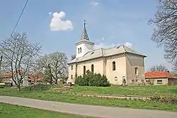 Church of Saint Bartholomew | |
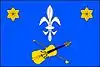 Flag 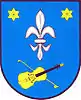 Coat of arms | |
 Býchory Location in the Czech Republic | |
| Coordinates: 50°4′4″N 15°16′25″E | |
| Country | |
| Region | Central Bohemian |
| District | Kolín |
| First mentioned | 1352 |
| Area | |
| • Total | 6.52 km2 (2.52 sq mi) |
| Elevation | 214 m (702 ft) |
| Population (2023-01-01)[1] | |
| • Total | 666 |
| • Density | 100/km2 (260/sq mi) |
| Time zone | UTC+1 (CET) |
| • Summer (DST) | UTC+2 (CEST) |
| Postal code | 280 02 |
| Website | www |
Geography
Býchory is located about 6 kilometres (4 mi) northeast of Kolín and 53 km (33 mi) east of Prague. The western part of the municipality with the village lies in the Central Elbe Table. The eastern part lies in the East Elbe Table. The highest point is the Homole hill at 279 m (915 ft) above sea level. The Hluboký Stream originates here and flows across the municipality.
History
The first written mention of Býchory is from 1352, when the church was documented.[2]
Sights
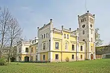
Býchory Castle (also called Horskýsfeld) is a manor house, built in the Tudor neo-Gothic style in 1865. It was owned by Jan Kubelík in 1904–1916.[3]
The Church of Saint Bartholomew is a building with a Gothic core. It was rebuilt in th Baroque style in 1854–1855.[4]
Notable people
- Jan Kubelík (1880–1940), violinist and composer; lived here
- Rafael Kubelík (1914–1996), Czech-Swiss conductor and composer
References
- "Population of Municipalities – 1 January 2023". Czech Statistical Office. 2023-05-23.
- "Historie" (in Czech). Obec Býchory. Retrieved 2022-06-09.
- "Památky" (in Czech). Obec Býchory. Retrieved 2022-06-09.
- "Kostel sv. Bartoloměje" (in Czech). National Heritage Institute. Retrieved 2023-07-06.