Dolní Chvatliny
Dolní Chvatliny is a municipality and village in Kolín District in the Central Bohemian Region of the Czech Republic. It has about 500 inhabitants.
Dolní Chvatliny | |
|---|---|
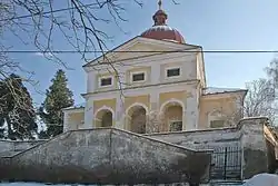 Church of Saints Peter and Paul | |
 Flag  Coat of arms | |
 Dolní Chvatliny Location in the Czech Republic | |
| Coordinates: 49°58′50″N 15°4′10″E | |
| Country | |
| Region | Central Bohemian |
| District | Kolín |
| First mentioned | 1250 |
| Area | |
| • Total | 12.23 km2 (4.72 sq mi) |
| Elevation | 295 m (968 ft) |
| Population (2023-01-01)[1] | |
| • Total | 499 |
| • Density | 41/km2 (110/sq mi) |
| Time zone | UTC+1 (CET) |
| • Summer (DST) | UTC+2 (CEST) |
| Postal code | 281 44 |
| Website | www |
Administrative parts
Villages of Horní Chvatliny and Mančice are administrative parts of Dolní Chvatliny.
Geography
Dolní Chvatliny is located about 10 kilometres (6 mi) southwest of Kolín and 39 km (24 mi) east of Prague. It lies in the Upper Sázava Hills. The highest point is at 354 m (1,161 ft) above sea level.
History
The first written mention of Chvatliny, when Dolní Chvatliny and Horní Chvatliny have not yet been distinguished, is from 1250.[2]
References
- "Population of Municipalities – 1 January 2023". Czech Statistical Office. 2023-05-23.
- "Paměti Chvatlin Horních a Dolních" (in Czech). Obec Dolní Chvatliny. Retrieved 2022-04-28.
This article is issued from Wikipedia. The text is licensed under Creative Commons - Attribution - Sharealike. Additional terms may apply for the media files.