Běrunice
Běrunice is a municipality and village in Nymburk District in the Central Bohemian Region of the Czech Republic. It has about 900 inhabitants.
Běrunice | |
|---|---|
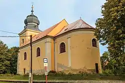
 Church of the Nativity of the Virgin Mary | |
 Flag  Coat of arms | |
 Běrunice Location in the Czech Republic | |
| Coordinates: 50°11′9″N 15°20′1″E | |
| Country | |
| Region | Central Bohemian |
| District | Nymburk |
| First mentioned | 1354 |
| Area | |
| • Total | 26.64 km2 (10.29 sq mi) |
| Elevation | 218 m (715 ft) |
| Population (2023-01-01)[1] | |
| • Total | 857 |
| • Density | 32/km2 (83/sq mi) |
| Time zone | UTC+1 (CET) |
| • Summer (DST) | UTC+2 (CEST) |
| Postal code | 289 08 |
| Website | www |
Administrative parts
Villages of Běruničky, Slibovice, Velké Výkleky and Vlkov nad Lesy are administrative parts of Běrunice.
Geography
Běrunice is located about 20 kilometres (12 mi) east of Nymburk and 56 km (35 mi) east of Prague. Most of the municipal territory lies in a flat agricultural landscape in the Central Elbe Table. However, the northeastern part extends into the East Elbe Table and includes the highest point of Běrunice at 272 m (892 ft) above sea level. The Štítarský Stream flows through the municipality.
History
The first written mention of Běrunice is from 1354. The nearby villages of Běruničky and Nový were historically administered by Běrunice, but Nový was attached to Městec Králové in 1950. In 1965, the municipalities of Slibovice, Velké Výkleky, Vlkov nad Lesy and Kněžičky were merged with Běrunice, but Kněžičky became independent again in 1990.[2]
Sights
The landmark of Běrunice is the Church of the Nativity of the Virgin Mary. It is a simple Baroque church from 1718, which replaced a demolished medieval church from the 14th century.[3]
Notable people
- František Janda (1886–1956), architect and urban planner
References
- "Population of Municipalities – 1 January 2023". Czech Statistical Office. 2023-05-23.
- "Obec Běrunice" (in Czech). Obec Běrunice. Retrieved 2023-03-03.
- "Kostel Narození Panny Marie" (in Czech). National Heritage Institute. Retrieved 2023-03-03.