Kostelní Lhota
Kostelní Lhota is a municipality and village in Nymburk District in the Central Bohemian Region of the Czech Republic. It has about 900 inhabitants.
Kostelní Lhota | |
|---|---|
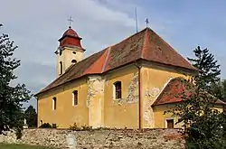 Church of the Assumption of the Virgin Mary | |
 Flag  Coat of arms | |
 Kostelní Lhota Location in the Czech Republic | |
| Coordinates: 50°7′46″N 15°1′27″E | |
| Country | |
| Region | Central Bohemian |
| District | Nymburk |
| First mentioned | 1354 |
| Area | |
| • Total | 8.65 km2 (3.34 sq mi) |
| Elevation | 187 m (614 ft) |
| Population (2023-01-01)[1] | |
| • Total | 916 |
| • Density | 110/km2 (270/sq mi) |
| Time zone | UTC+1 (CET) |
| • Summer (DST) | UTC+2 (CEST) |
| Postal code | 289 12 |
| Website | www |
Geography
Kostelní Lhota is located about 6 kilometres (4 mi) south of Nymburk and 34 km (21 mi) east of Prague. It lies in a flat landscape in the Central Elbe Table. The Výrovka River flows along the eastern and northeastern municipal border. The Šembera River, its tributary, flows along the northwestern border.
History
The first written mention of Kostelní Lhota is from 1354.[2]
Transport
The D11 motorway (part of the European route E67) from Prague to Hradec Králové passes through the municipality.
Sights
The landmark of Kostelní Lhota is the Church of the Assumption of the Virgin Mary. It was built in the late Baroque style in 1817.[3]
Notable people
- Josef Musil (1932–2017), volleyball player
References
- "Population of Municipalities – 1 January 2023". Czech Statistical Office. 2023-05-23.
- "Historie" (in Czech). Obec Kostelní Lhota. Retrieved 2023-03-03.
- "Kostel Nanebevzetí Panny Marie" (in Czech). National Heritage Institute. Retrieved 2023-03-03.