B postcode area
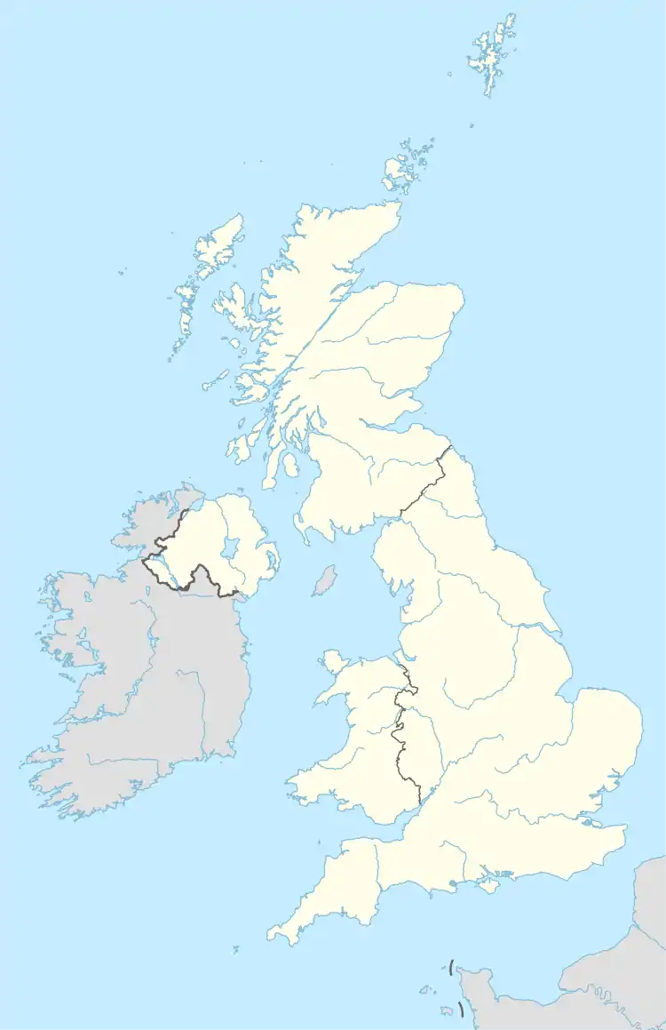
The B postcode area, also known as the Birmingham postcode area,[2] is a group of 79 postcode districts in central England, within 15 post towns. These cover the central portion of the West Midlands (including Birmingham, West Bromwich, Sutton Coldfield, Smethwick, Solihull, Halesowen, Cradley Heath, Oldbury and Rowley Regis), plus northeast Worcestershire (including Bromsgrove and Redditch), north and west Warwickshire (including Alcester, Coleshill, Studley and Henley-in-Arden), and part of southeast Staffordshire (including Tamworth) and a very small part of Leicestershire. It is the most populated postcode area in the United Kingdom, with a population of over 1.9 million.
Birmingham | |
|---|---|
 B | |
| Coordinates: 52.463°N 1.889°W | |
| Country | United Kingdom |
| Postcode area | B |
| Postcode area name | Birmingham |
| Post towns | 15 |
| Postcode districts | 79 |
| Postcode sectors | 268 |
| Postcodes (live) | 41,397 |
| Postcodes (total) | 61,202 |
| Statistics as at May 2020[1] | |
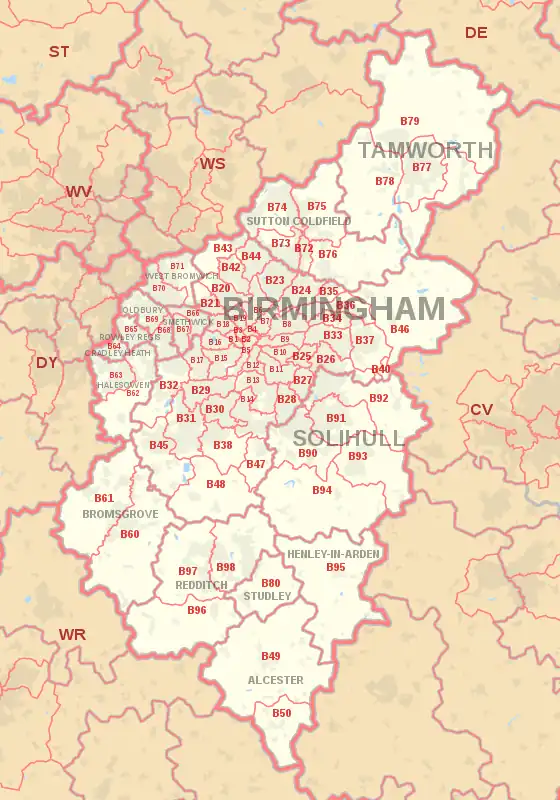
Coverage
The approximate coverage of the postcode districts:
| Postcode district | Post town | Coverage | Local authority area(s) |
|---|---|---|---|
| B1 | BIRMINGHAM | Birmingham City Centre, Broad Street (east) | Birmingham |
| B2 | BIRMINGHAM | Birmingham City Centre, New Street | Birmingham |
| B3 | BIRMINGHAM | Birmingham City Centre, Newhall Street | Birmingham |
| B4 | BIRMINGHAM | Birmingham City Centre, Corporation Street (north) | Birmingham |
| B5 | BIRMINGHAM | Digbeth, Highgate, Lee Bank, Edgbaston | Birmingham |
| B6 | BIRMINGHAM | Aston, Birchfield , Witton | Birmingham |
| B7 | BIRMINGHAM | Nechells, Vauxhall | Birmingham |
| B8 | BIRMINGHAM | Washwood Heath, Ward End, Saltley, Alum Rock | Birmingham |
| B9 | BIRMINGHAM | Bordesley Green, Bordesley | Birmingham |
| B10 | BIRMINGHAM | Small Heath | Birmingham |
| B11 | BIRMINGHAM | Sparkhill, Sparkbrook, Tyseley | Birmingham |
| B12 | BIRMINGHAM | Balsall Heath, Sparkbrook, Highgate | Birmingham |
| B13 | BIRMINGHAM | Moseley, Billesley | Birmingham |
| B14 | BIRMINGHAM | Kings Heath, Yardley Wood, Druids Heath, Highter's Heath, Warstock | Birmingham |
| B15 | BIRMINGHAM | Edgbaston | Birmingham |
| B16 | BIRMINGHAM | Ladywood, Edgbaston | Birmingham |
| B17 | BIRMINGHAM | Harborne, Edgbaston | Birmingham |
| B18 | BIRMINGHAM | Winson Green, Hockley | Birmingham |
| B19 | BIRMINGHAM | Lozells, Newtown, Birchfield | Birmingham |
| B20 | BIRMINGHAM | Handsworth Wood, Handsworth, Birchfield | Birmingham |
| B21 | BIRMINGHAM | Handsworth | Birmingham |
| B23 | BIRMINGHAM | Erdington, Stockland Green, Short Heath, Perry Common | Birmingham |
| B24 | BIRMINGHAM | Erdington, Wylde Green, Tyburn | Birmingham |
| B25 | BIRMINGHAM | Yardley, Hay Mills | Birmingham |
| B26 | BIRMINGHAM | Sheldon, Yardley, Birmingham International Airport | Birmingham, Solihull |
| B27 | BIRMINGHAM | Acocks Green | Birmingham |
| B28 | BIRMINGHAM | Hall Green | Birmingham |
| B29 | BIRMINGHAM | Selly Oak, Bournbrook, Selly Park, Weoley Castle, California (part of) | Birmingham |
| B30 | BIRMINGHAM | Bournville, Cotteridge, Stirchley, Kings Norton (North) | Birmingham |
| B31 | BIRMINGHAM | Northfield, Longbridge, West Heath | Birmingham |
| B32 | BIRMINGHAM | Woodgate, Bartley Green, Quinton, California (part of) | Birmingham |
| B33 | BIRMINGHAM | Kitts Green, Stechford | Birmingham |
| B34 | BIRMINGHAM | Shard End, Buckland End | Birmingham |
| B35 | BIRMINGHAM | Castle Vale | Birmingham |
| B36 | BIRMINGHAM | Castle Bromwich, Smith's Wood, Bromford, Hodge Hill | Birmingham, Solihull |
| B37 | BIRMINGHAM | Chelmsley Wood, Marston Green, Kingshurst, Fordbridge | Solihull |
| B38 | BIRMINGHAM | Kings Norton (South), | Birmingham |
| B40 | BIRMINGHAM | National Exhibition Centre, Birmingham International Airport, Marston Green, Bickenhill | Solihull |
| B42 | BIRMINGHAM | Perry Barr, Great Barr, Hamstead | Birmingham |
| B43 | BIRMINGHAM | Great Barr, Hamstead | Birmingham, Sandwell, Walsall |
| B44 | BIRMINGHAM | Perry Barr, Kingstanding, Great Barr | Birmingham |
| B45 | BIRMINGHAM | Rednal, New Frankley, Rubery, Cofton Hackett, Barnt Green, Lickey, Longbridge, Northfield (part) | Birmingham, Bromsgrove |
| B46 | BIRMINGHAM | Coleshill, Water Orton, Shustoke, Nether Whitacre | North Warwickshire |
| B47 | BIRMINGHAM | Hollywood, Wythall | Bromsgrove |
| B48 | BIRMINGHAM | Alvechurch | Bromsgrove |
| B49 | ALCESTER | Alcester | Stratford-on-Avon |
| B50 | ALCESTER | Bidford-on-Avon | Stratford-on-Avon |
| B60 | BROMSGROVE | Bromsgrove (east) | Bromsgrove |
| B61 | BROMSGROVE | Bromsgrove (west) | Bromsgrove |
| B62 | HALESOWEN | Halesowen (east), Romsley, Hunnington, Quinton (part) | Dudley, Bromsgrove, Birmingham |
| B63 | HALESOWEN | Halesowen (west and town centre), Hayley Green, Hasbury | Dudley, Bromsgrove |
| B64 | CRADLEY HEATH | Cradley Heath, Old Hill | Sandwell |
| B65 | ROWLEY REGIS | Rowley Regis, Blackheath | Sandwell |
| B66 | SMETHWICK | Smethwick (east and north), Bearwood (east) | Sandwell |
| B67 | SMETHWICK | Smethwick (west), Bearwood (west), Londonderry | Sandwell |
| B68 | OLDBURY | Langley, Brandhall, Quinton (part of) | Sandwell |
| B69 | OLDBURY | Oldbury, Tividale | Sandwell |
| B70 | WEST BROMWICH | West Bromwich (south, west and town centre) | Sandwell |
| B71 | WEST BROMWICH | West Bromwich (north) | Sandwell |
| B72 | SUTTON COLDFIELD | Sutton Coldfield town centre, Maney, Wylde Green | Birmingham |
| B73 | SUTTON COLDFIELD | Boldmere, New Oscott, Wylde Green (part) | Birmingham |
| B74 | SUTTON COLDFIELD | Four Oaks, Little Aston, Streetly | Birmingham, Lichfield, Walsall |
| B75 | SUTTON COLDFIELD | Mere Green, Roughley, Moor Hall, Whitehouse Common, Falcon Lodge | Birmingham |
| B76 | SUTTON COLDFIELD | Walmley, Minworth, Curdworth, Lea Marston | Birmingham, North Warwickshire |
| B77 | TAMWORTH | Tamworth, Wilnecote, Amington | Tamworth, North Warwickshire |
| B78 | TAMWORTH | Tamworth, Fazeley, Kingsbury, Polesworth | Tamworth, North Warwickshire |
| B79 | TAMWORTH | Tamworth, Warton | Tamworth, North Warwickshire, North West Leicestershire |
| B80 | STUDLEY | Studley | Stratford-on-Avon |
| B90 | SOLIHULL | Shirley, Solihull Lodge, Major's Green, Dickens Heath, Cheswick Green | Solihull, Bromsgrove |
| B91 | SOLIHULL | Solihull | Solihull |
| B92 | SOLIHULL | Olton, Elmdon, Bickenhill, Hampton-in-Arden | Solihull |
| B93 | SOLIHULL | Baddesley Clinton , Bentley Heath, Dorridge, Knowle, Tilehouse Green | Solihull |
| B94 | SOLIHULL | Hockley Heath, Earlswood | Solihull, Warwick |
| B95 | HENLEY-IN-ARDEN | Henley-in-Arden, Wooton Wawen, Beaudesert | Stratford-on-Avon |
| B96 | REDDITCH | Feckenham, Astwood Bank, Bradley Green | Redditch |
| B97 | REDDITCH | Redditch (west), Callow Hill, Webheath | Redditch |
| B98 | REDDITCH | Redditch (east), Beoley | Redditch |
| B99 | BIRMINGHAM | non-geographic |
Notes
- The B postcode area as a whole, is the largest by population.[3]
- B1 1AA is Birmingham Head Post office; this is no longer in the B1 area, but retains the B1 code.
- B1 1BB is Birmingham Council House[4]
Maps

Former scheme

Before the introduction of postcodes in the 1960s, Birmingham along with other major cities were divided into numbered postal districts. With a few exceptions these were directly incorporated into the outcode (the first part of the postcode).
For example, Great Barr was formerly Birmingham 22 (now B43 and 44) and Smethwick was formerly Smethwick 40 and 41 (now B66 and 67).
References
- "ONS Postcode Directory Version Notes" (ZIP). National Statistics Postcode Products. Office for National Statistics. May 2020. Table 2. Retrieved 19 June 2020. Coordinates from mean of unit postcode points, "Code-Point Open". OS OpenData. Ordnance Survey. February 2012. Retrieved 21 April 2012.
- Royal Mail, Address Management Guide, (2004)
- "FOI request: Population for every postcode district in England and Wales". The National Archives. Archived from the original on 5 January 2016. Retrieved 26 April 2021.
{{cite web}}: CS1 maint: bot: original URL status unknown (link) - "Contact Us". Birmingham City Council. Archived from the original on 9 September 2009. Retrieved 4 August 2009.