North Warwickshire
North Warwickshire is a local government district with borough status in the ceremonial county of Warwickshire, West Midlands, England. The borough includes the two towns of Atherstone (where the council is based) and Coleshill, and the large villages of Polesworth, Kingsbury, Hartshill and Water Orton.
Borough of North Warwickshire | |
|---|---|
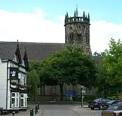 Atherstone, the administrative centre of the borough and one of the two towns | |
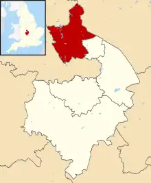 Shown within Warwickshire | |
| Sovereign state | United Kingdom |
| Constituent country | England |
| Region | West Midlands |
| Administrative county | Warwickshire |
| Founded | 1974 |
| Admin. HQ | Atherstone |
| Government | |
| • Type | Non-metropolitan district |
| • Leadership: | Alternative – Section 31 |
| • MPs: | Craig Tracey Marcus Jones |
| • Leader | David Humphreys |
| • Executive | Conservative |
| Area | |
| • Total | 109.8 sq mi (284.3 km2) |
| • Rank | 123rd |
| Population (2011 census) | |
| • Total | 62,014[1] |
| • Rank | Ranked 288th |
| Time zone | UTC+0 (Greenwich Mean Time) |
| • Summer (DST) | UTC+1 (British Summer Time) |
| Postcode | |
| ONS code | 44UB (ONS) E07000218 (GSS) |
| Ethnicity | 97.8% White (95.9% White British) 1.1% Asian 0.7% Mixed 0.2% Black 0.1% Other[2] |
| Website | northwarks.gov.uk |

The North Warwickshire district was created on 1 April 1974 by a merger of the Atherstone Rural District and parts of the Meriden Rural District (the rest of which was merged into the West Midlands county).[3]
North Warwickshire is a mostly rural area with several small market towns and a number of former mining villages. The area historically had a large coal mining industry, but this has now all died out. The last coal mine in the area, Daw Mill at Arley, closed in 2013.[4] The district is relatively remote from the rest of Warwickshire, as the county is almost split in two by the West Midlands Boroughs of Solihull and Coventry.
The borough borders the neighboring Warwickshire district of Nuneaton and Bedworth to the south-south-east, Staffordshire to the west and northwest, Leicestershire to the north and northeast, the cities of Birmingham and Coventry to the southwest and southeast.
The borough's landscape is primarily of the mildly undulating agricultural variety, with the North Warwickshire plateau rising to 177 m (581 ft) above sea-level at Bentley Common, 2.5 miles southwest of Atherstone. The most significant bodies of water within North Warwickshire are Kingsbury Water Park, Shustoke Reservoir, the River Blythe and the mid-section of the Coventry Canal.
The boundaries of North Warwickshire are similar to those of the North Warwickshire parliamentary constituency. However the constituency also includes the town of Bedworth, but does not include the villages of Hartshill and Arley. The local MP is Craig Tracey.
In 2007 the Conservatives took overall control of the borough council for the first time since the creation of the council within its current boundaries. The council was retaken by Labour in 2011, then returned to Conservative control in 2015.
Parishes and settlements
Settlements in North Warwickshire include:
- Ansley, Arley (Old Arley & New Arley), Astley, Atherstone, Austrey
- Baddesley Ensor, Baxterley, Bentley, Birchley Heath, Birchmoor, Blythe End
- Caldecote, Coleshill, Curdworth, Corley (Corley Ash & Corley Moor North).
- Dordon, Duke End
- Fillongley, Freasley, Furnace End
- Gilson, Great Packington, Grendon (Grendon Common, New Grendon, Old Grendon)
- Hartshill, Heath Whitacre, Hurley, Hurley Common
- Kingsbury
- Lea Marston, Little Packington
- Mancetter, Maxstoke, Merevale, Middleton, Moxhull
- Nether Whitacre, Newton Regis, No Man's Heath
- Over Whitacre
- Polesworth, Piccadilly
- Ridge Lane Village
- Seckington, Shustoke, Shuttington,
- Warton, Water Orton, Whitacre Heath, Whittington, Wiggins Hill, Wishaw, Wood End (near Kingsbury), Wood End (near Fillongley)
For a list of wards in North Warwickshire by population see here
Local election results 1973-2023

As of May 2023, the party composition was as follows:[5]
| Party | Number of councillors |
|---|---|
| Conservative | 17 |
| Labour | 15 |
| Independent | 3 |

Historically, local election results have fallen like this:
| Election year | Conservative | Labour | Liberal Democrats | Ratepayers | Independent | Note |
|---|---|---|---|---|---|---|
| 2023 | 17 | 15 | 0 | 0 | 3 | |
| 2019 | 21 | 14 | 0 | 0 | 0 | |
| 2015 | 22 | 13 | 0 | 0 | 0 | |
| 2011 | 17 | 18 | 0 | 0 | 0 | |
| 2007 | 21 | 14 | 0 | 0 | 0 | |
| 2003 | 15 | 16 | 4 | 0 | 0 | Boundary Changes in effect |
| 1999 | 9 | 22 | 2 | 0 | 1 | |
| 1995 | 4 | 29 | 0 | 0 | 1 | |
| 1973 | 8 | 19 | 0 | 2 | 4 |
Parties
The borough is a very marginal seat between the Conservatives and Labour. Within the Borough, Polesworth East, Dordon, and Wood End are considered Labour safe seats, and Fillongley, Water Orton, Newton Regis and Curdworth are considered safe Conservative seats. However, in the Local Elections of May 2023 for Water Orton the largest number of votes were cast for an independent councillor although the other returned councillor remained Conservative.[6]
See also
References
- Release Edition Reference Tables. Ons.gov.uk (17 December 2012). Retrieved on 17 July 2013.
- "UK Government Web Archive". webarchive.nationalarchives.gov.uk.
- "Warwickshire Civic Heraldry". Civic heraldry. Retrieved 19 August 2021.
- "Daw Mill: Hundreds of jobs go at fire-hit mine". BBC News. 7 March 2013. Retrieved 24 December 2018.
- "North Warwickshire result – Local Elections 2023". BBC News. Retrieved 5 May 2023.
- "Election Results".
| Boroughs or districts | |
|---|---|
| Major settlements (cities in italics) | |
| Rivers | |
| Canals | |
| Topics | |
