Barenton-sur-Serre
Barenton-sur-Serre (French pronunciation: [baʁɑ̃tɔ̃ syʁ sɛʁ], literally Barenton on Serre) is a commune in the department of Aisne in the Hauts-de-France region of northern France.
Barenton-sur-Serre | |
|---|---|
Commune | |
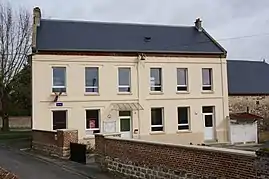 Town hall | |
Location of Barenton-sur-Serre | |
 Barenton-sur-Serre  Barenton-sur-Serre | |
| Coordinates: 49°40′20″N 3°40′52″E | |
| Country | France |
| Region | Hauts-de-France |
| Department | Aisne |
| Arrondissement | Laon |
| Canton | Marle |
| Intercommunality | Pays de la Serre |
| Government | |
| • Mayor (2020–2026) | Christian Lecuyer[1] |
| Area 1 | 8.05 km2 (3.11 sq mi) |
| Population | 131 |
| • Density | 16/km2 (42/sq mi) |
| Time zone | UTC+01:00 (CET) |
| • Summer (DST) | UTC+02:00 (CEST) |
| INSEE/Postal code | 02048 /02270 |
| Elevation | 61–122 m (200–400 ft) |
| 1 French Land Register data, which excludes lakes, ponds, glaciers > 1 km2 (0.386 sq mi or 247 acres) and river estuaries. | |
Geography
Barenton-sur-Serre is located some 35 km southeast of Saint-Quentin and 15 km northeast of Laon. National Route N2 passes through the commune from Froidmont-Cohartille in the northeast running southwest through the commune. Access to the village is by road D3060 running west from the N2 to the village then continuing north-west to road D12. There is also access to the village on a country road from Froidmont-Cohartille. There is quite a large area of forest north of the village and in a belt extending southeast of the village. The rest of the commune is all farmland.[3]
The Ru de Barentons flows from the south of the commune into the Souche river which flows from east to west through the commune then continues northwest to join the Serre river.[3]
Neighbouring communes and villages
Places adjacent to Barenton-sur-Serre | |
|---|---|
Administration
List of Successive Mayors of Barenton-sur-Serre[4]
| From | To | Name | Party |
|---|---|---|---|
| 1995 | 2008 | Gérard Cuvillier | DVD |
| 2008 | 2014 | Sébastien Lhermine | |
| 2014 | 2020 | Bruno Séverin | |
| 2020 | Present | Christian Lecuyer |
Population
| Year | Pop. | ±% p.a. |
|---|---|---|
| 1968 | 109 | — |
| 1975 | 97 | −1.65% |
| 1982 | 112 | +2.08% |
| 1990 | 106 | −0.69% |
| 1999 | 109 | +0.31% |
| 2007 | 111 | +0.23% |
| 2012 | 118 | +1.23% |
| 2017 | 134 | +2.58% |
| Source: INSEE[5] | ||
Gallery
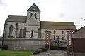 The Church
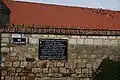 Jedburgh Augustus Memorial
 The Souche river from the bridge
 The War Memorial
See also
References
- "Répertoire national des élus: les maires". data.gouv.fr, Plateforme ouverte des données publiques françaises (in French). 2 December 2020.
- "Populations légales 2020". The National Institute of Statistics and Economic Studies. 29 December 2022.
- Google Maps
- List of Mayors of France (in French)
- Population en historique depuis 1968, INSEE
External links
- Barenton-sur-Serre on the old National Geographic Institute website (in French)
- 40000 Bell Towers website (in French)
- Barenton-sur-Serre on Géoportail, National Geographic Institute (IGN) website (in French)
- Baranton sur Serre on the 1750 Cassini Map