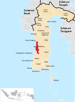
Barru Regency
Barru Regency is a regency of South Sulawesi Province of Indonesia. It covers an area of 1,174.72 km2 and had a population of 165,983 at the 2010 Census[2] and 184,452 at the 2020 Census;[3] the official estimate as at mid 2022 was 186,910 (comprising 91,453 males and 95,457 females).[1] The principal town lies at Barru.
Barru Regency
Kabupaten Barru | |
|---|---|
 Coat of arms | |
| Motto: HIBRIDAH (HIjau Bersih asRI dan inDAH) | |
 Location within South Sulawesi | |
| Country | Indonesia |
| Province | South Sulawesi |
| Capital | Barru |
| Government | |
| Area | |
| • Total | 1,174.71 km2 (453.56 sq mi) |
| Population (mid 2022 estimate)[1] | |
| • Total | 186,910 |
| • Density | 160/km2 (410/sq mi) |
| Time zone | UTC+8 (ICST) |
| Area code | (+62) 427 |
| Website | http://barrukab.go.id |
Administration
Barru Regency in 2020, as in 2010, comprised seven administrative Districts (Kecamatan), tabulated below from south to north with their areas and their populations at the 2010 Census[2] and at the 2020 Census,[3] together with the official estimates as at mid 2022.[1] The table also includes the location of the district administrative centres,the numbers of administrative villages (rural desa and urban kelurahan) in each district, and its postal code(s).
| Name of District (kecamatan) | Area in km2 | Pop'n Census 2010 | Pop'n Census 2020 | Pop'n Estimate mid 2022 | Admin centre | No. of villages (desa/kel.) | Post code |
|---|---|---|---|---|---|---|---|
| Pujananting | 314.26 | 12,785 | 13,104 | 13,119 | Mattappawalie | 6/1 | 90760 |
| Tanete Riaja | 174.29 | 21,899 | 25,217 | 25,718 | Lompo Riaja | 6/1 | 90763 |
| Tanete Rilau | 79.17 | 32,763 | 37,196 | 37,831 | Lalolang | 8/2 | 90761 (a) |
| Barru | 199.32 | 38,333 | 43,975 | 44,817 | Sumpang Binangae | 5/5 | 90711 & 90712 |
| Balusu | 112.20 | 17,575 | 18,913 | 19,038 | Takkalasi | 5/1 | 90762 |
| Soppeng Riaja | 58.90 | 17,598 | 18,471 | 18,503 | Mangkoso | 5/2 | 90752 |
| Mallusetasi | 216.58 | 25,030 | 27,576 | 27,884 | Palanro | 5/1 | 90753 (b) |
| Totals | 1,174.72 | 165,983 | 184,452 | 186,910 | Barru | 40/15 |
Notes: (a) except the desa of Garessi, which has a post code of 90711.
(b) except the kelurahan of Mallawa, which has a post code of 90711.
References
- Badan Pusat Statistik, Jakarta, 2023, Kabupaten Barru Dalam Angka 2023 (Katalog-BPS 1102001.7311)
- Biro Pusat Statistik, Jakarta, 2011.
- Badan Pusat Statistik, Jakarta, 2021.
