Baykurut
Baykurut[1][4] Township also Baykurt[5][6] (بايقۇرۇت يېزىسى[7][8] / Байқурут[9] / Bayinkuluti simplified Chinese: 巴音库鲁提乡; traditional Chinese: 巴音庫魯提鄉; pinyin: Bāyīnkùlǔtí Xiāng) is a township of Wuqia County in Kizilsu Kyrgyz Autonomous Prefecture, Xinjiang Uygur Autonomous Region, China. Baykurut is located in the central to eastern part of the county. It has 2 administrative villages under its jurisdiction. Its seat is at Baykurut Village (巴音库鲁提村).[1]
Baykurut
بايقۇرۇت يېزىسى 巴音库鲁提乡 Baykurt, Bayinkuluti | |
|---|---|
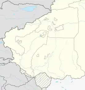
 Baykurut Location of the township | |
| Coordinates: 39.9452498225°N 75.5486637353°E | |
| Country | People's Republic of China |
| Autonomous region | Xinjiang |
| Prefecture | Kizilsu |
| County | Wuqia |
| Area | |
| • Total | 1,317 km2 (508 sq mi) |
| Population (2010)[3] | |
| • Total | 2,225 |
| Ethnic groups | |
| • Major ethnic groups | Kyrgyz[2] |
| Time zone | UTC+8 (China Standard Time) |
| Website | www |
Baykurut is located 65 km (40 mi) away northeast of the county seat Wuqia Town and 23 km (14 mi) south of Turugart Port (托帕口岸). It is adjacent to Terak Township in the east, Artux City and Wuqia Town in the south, Toyun Township in the north. It is bordered by the Kyrghyz Republic with a boundary line of 40 kilometers in the west.[10]
Name
The name Baykurut is derived from the Kyrgyz language. Baykurut was named after Kurut (قۇرۇت / Kuluti, 库鲁提), a rich person who lived in the Baykurut area.[1]
History
Baykurut was the 3rd township of the 4th district in Wuqia County in 1950 and part of Toyun Commune (托云公社) in 1958, Baykurut Commune was formed from Toyun in 1962.[1][2]
In 1968 during the Cultural Revolution, the commune was renamed Hongqi Commune (literally 'Red flag commune', 红旗公社). The original name was restored in 1980.[1][2]
Geography


The township's seat is at 2,310 meters above sea level. The highest altitude is 4,200 meters at Karadob (喀拉多别), the lowest altitude is 1,900 meters at Topa (托帕).[10]
Settlements
The township has 2 administration villages[11] and 5 unincorporated villages under its jurisdiction.[1][2]
2 administration villages:
Demographics
| Year | Pop. | ±% p.a. |
|---|---|---|
| 2000 | 2,304 | — |
| 2010 | 2,225 | −0.35% |
| [3] | ||
Economy
As of 2004, economically poor persons made up 20.74% of the population of Baykurut and the net mean income in the township was 1,365 RMB.[12]
Transportation
- China-Kyrgyzstan S212 Provincial Highway (中吉公路S212省道) to Torugart Pass[2]
References
- 乌恰县行政区划和居民地名称 (in Simplified Chinese). xjwqx.gov.cn. 2018-06-04. Archived from the original on 8 October 2020. Retrieved 2019-10-21 – via Google Cache, Internet Archive.
- 1997年乌恰县行政区划 [1997 Ulugqat County Administrative Divisions] (in Simplified Chinese). XZQH.org. 31 December 2010. Archived from the original on 15 October 2017. Retrieved 5 October 2020.
巴音库鲁提乡 位于县城东北41千米。 面积1317.3平方千米,人口0.2万,其中柯尔克孜族占99.2%,辖巴音库鲁提、克孜勒阿根2个行政村。1950年成立巴音库鲁提三乡,1962年建巴音库鲁提公社,1968年更名红旗公社,1984年改设巴音库鲁提乡。吐尔尕特口岸公路从乡中部穿过。恰克玛克河穿境而过,水源丰富。境内驻有新疆生产建设兵团农三师二牧场。
- 乌恰县历史沿革. XZQH.org (in Simplified Chinese). 29 January 2015. Archived from the original on 15 October 2017. Retrieved 5 October 2020.
2000年第五次人口普查,乌恰县常住总人口42002人,其中:{...}巴音库鲁提乡2304人、{...}2010年第六次人口普查,乌恰县常住总人口47261人,其中:{...}巴音库鲁提乡2225人,{...
} - Baykurut (Variant - V) at GEOnet Names Server, United States National Geospatial-Intelligence Agency
- Baykurt (Variant - V) at GEOnet Names Server, United States National Geospatial-Intelligence Agency
- Gazetteer of the People's Republic of China. United States Board on Geographic Names. July 1979. p. 744 – via Google Books.
Pa-yin-k'u-lu-t'i Baykurt PPL 39 56 N 75 33 E CH13
- Amangul Abdurrahman ئامانگۈل ئابدۇراخمان, ed. (21 August 2020). پورتقا قوشنا بولۇپ پۇلنى ياخشى تاپتى. Tianshannet (in Uyghur). Archived from the original on 8 October 2020. Retrieved 8 October 2020.
- بايقۇرۇت (Variant Non-Roman Script - VS) at GEOnet Names Server, United States National Geospatial-Intelligence Agency
- Байқурут (Variant Non-Roman Script - VS) at GEOnet Names Server, United States National Geospatial-Intelligence Agency
- 巴音库鲁提乡. xjwqx.gov.cn. 2018-05-29. Archived from the original on 9 October 2020. Retrieved 2019-10-21 – via Google Cache, Internet Archive.
- 2018年乌恰县巴音库鲁提乡行政区划代码. National Bureau of Statistics of China. 2018-10-31. Retrieved 2019-10-21.
- Communication Construction Administration Bureau of Xinjiang Uigur Autonomous Region (September 2007). "PRC: Xinjiang Regional Road Improvement Project (Korla-Kuqa Section)" (PDF). Asian Development Bank. p. I. Archived (PDF) from the original on 10 July 2020.