Borough of Bedford
The Borough of Bedford is a unitary authority area with borough status in the ceremonial county of Bedfordshire, England. Its council is based in Bedford, its namesake and principal settlement, which is the county town of Bedfordshire. The borough contains one large urban area, the 71st largest in the United Kingdom that comprises Bedford and the adjacent town of Kempston, surrounded by a rural area with many villages. 75% of the borough's population live in the Bedford Urban Area and the five large villages which surround it, which makes up slightly less than 6% of the total land area of the Borough.
Bedford
Borough of Bedford | |
|---|---|
 | |
 Coat of arms of Bedford Borough Council | |
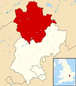 Bedford shown within Bedfordshire | |
| Coordinates: 52°8′0″N 0°27′0″W | |
| Sovereign state | |
| Country | |
| Region | East of England |
| Ceremonial county | Bedfordshire |
| Administrative HQ | Borough Hall, Bedford |
| Government | |
| • Type | Unitary Authority |
| • Governing body | Bedford Borough Council |
| • MPs | Richard Fuller (C) Alistair Strathern (L) Mohammad Yasin (L) |
| Area | |
| • Total | 476.4 km2 (183.9 sq mi) |
| Population (2021)[1] | |
| • Total | 185,761 |
| • Rank | 107th |
| • Density | 390/km2 (1,000/sq mi) |
| • Ethnicity | 85.5% White British 8.1% British Asian 2.9% Black British 1.3% Chinese or other 2.2% Mixed |
| Time zone | GMT |
| • Summer (DST) | British Summer Time |
| ONS code | 00KB |
| NUTS 3 | UKH22 |
| Website | www |
The borough is also the location of the Wixams new town development, which received its first residents in 2009.
History
The ancient borough of Bedford was a borough by prescription, with its original date of incorporation unknown. The earliest surviving charter was issued c. 1166 by Henry II, confirming to the borough the liberties and customs which it had held in the reign of Henry I.[2][3] The borough became a municipal borough under the Municipal Corporations Act 1835.
The District of Bedford was formed on 1 April 1974 as a merger of the existing borough of Bedford, along with Kempston Urban District and Bedford Rural District. In 1975 the district was granted a royal charter granting borough status as North Bedfordshire.[4] The borough changed its name back from North Bedfordshire to Bedford in 1992.[5]
Bedfordshire's administrative structure was reorganised as part of the 2009 structural changes to local government in England, meaning that Bedford Borough Council became a unitary authority in April 2009. Bedford Borough Council assumed responsibility in areas such as education, social services and transport which were previously provided by Bedfordshire County Council.[6][7][8]
Governance
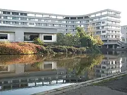
The council is based at Borough Hall on Cauldwell Street on the banks of the River Great Ouse in the centre of Bedford. The building was previously known as County Hall and had been the headquarters of Bedfordshire County Council prior to 2009.
Parishes
Most of the area of the pre-1974 municipal borough of Bedford is unparished, although the parish of Brickhill was created within that area in 2004. The rest of the modern borough, including Kempston, is parished. The parishes are:[9]
- Biddenham
- Bletsoe
- Bolnhurst and Keysoe
- Brickhill
- Bromham
- Cardington
- Carlton and Chellington
- Clapham
- Colmworth
- Cople
- Cotton End
- Dean and Shelton
- Elstow
- Felmersham
- Great Barford
- Great Denham
- Harrold
- Kempston
- Kempston Rural
- Knotting and Souldrop
- Little Barford
- Little Staughton
- Melchbourne and Yielden
- Milton Ernest
- Oakley
- Odell
- Pavenham
- Pertenhall
- Podington
- Ravensden
- Renhold
- Riseley
- Roxton
- Sharnbrook
- Shortstown
- Stagsden
- Staploe
- Stevington
- Stewartby
- Swineshead
- Thurleigh
- Turvey
- Wilden
- Willington
- Wilshamstead
- Wixams
- Wootton
- Wyboston, Chawston and Colesden
- Wymington
Freedom of the Borough
The following people and military units have received the Freedom of the Borough of Bedford.
Individuals
- Etienne Stott: 11 December 2012.[10]
Military Units
- Bedfordshire and Hertfordshire Regiment: November 1955
- RAF Cardington: 16 July 1959.[11]
- 287 Regiment Royal Artillery: 5 May 1963.
- 1st Battalion Royal Anglian Regiment: 1980.[12]
- 201 (Hertfordshire and Bedfordshire Yeomanry) Battery Royal Artillery (Volunteers): 3 May 1986.
- RAF Henlow: 26 September 1992.
- 774th USAF Airbase Group: 15 December 1994.
- 134 (Bedford) Squadron Air Training Corps: 1 August 1999.
References
- "Mid-Year Population Estimates, UK, June 2021". Office for National Statistics. 21 December 2022. Retrieved 18 October 2023.
- Page, William, ed. (1912). "The Borough of Bedford". A History of the County of Bedford: Volume 3. British History Online. Retrieved 8 August 2021.
- "Bedford Borough records introduction". Bedfordshire Archives. Retrieved 8 August 2021.
- North Bedfordshire Borough Council, London Gazette, 31 October 1975, page 13813. Change of name and status from Bedford District to North Bedfordshire Borough with effect from 16 October 1975.
- Bulletin of Changes of Local Authority Status, Names and Areas, 1 April 1992 - 31 March 1993 (Department of the Environment). Change of name from North Bedfordshire to Bedford effective from 1 October 1992.
- Unitary solution confirmed for Bedfordshire – New flagship unitary councils approved for Cheshire – Corporate – Communities and Local Government Archived 22 November 2008 at the Wayback Machine
- County council to be abolished in shake-up – Bedford Today
- A New Beginning Archived 24 February 2009 at archive.today
- "Election Maps". Ordnance Survey. Retrieved 10 May 2023.
- "Olympic canoeist Etienne Stott given freedom of Bedford". BBC News. 11 December 2012.
- "RAF Cardington Camp". rafcardingtoncamp.co.uk.
- "In pictures: Royal Anglians march through Bedford". BBC News. 22 July 2014.
External links
| Unitary authorities | |
|---|---|
| Major settlements (cities in italics) | |
| Topics |
|