Bellville, South Africa
Bellville is a town and former independent city that is now incorporated into the City of Cape Town Metropolitan Municipality in the Western Cape province of South Africa. The town is an industrial and commercial node, a university town, and a major transportation hub within the Greater Cape Town metropolis.
Bellville | |
|---|---|
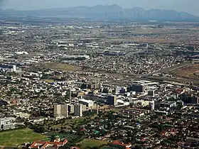  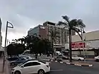 From top, an areal view of Bellville CBD with Kogelberg Mountains and False Bay in distance. Bottom left, Bellville town center and TV tower as seen from Tielman Marais Park. Bottom right, University of the Western Cape Community and Health Sciences faculty at its Bellville campus. | |
 Coat of arms | |
 Bellville 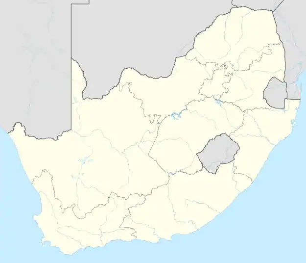 Bellville  Bellville | |
| Coordinates: 33°54′00″S 18°38′00″E | |
| Country | South Africa |
| Province | Western Cape |
| Municipality | City of Cape Town |
| Established | 1861 |
| Area | |
| • Total | 52.39 km2 (20.23 sq mi) |
| Population (2011)[1] | |
| • Total | 112,507 |
| • Density | 2,100/km2 (5,600/sq mi) |
| Racial makeup (2011) | |
| • Black African | 15.7% |
| • Coloured | 29.4% |
| • Indian/Asian | 1.5% |
| • White | 50.3% |
| • Others | 3.1% |
| First languages (2011) | |
| • Afrikaans | 65.4% |
| • English | 25.2% |
| • Xhosa | 2.5% |
| • Others | 7.0% |
| Time zone | UTC+2 (SAST) |
| Postal code (street) | 7530 |
| PO box | 7535 |
| Area code | 021 |
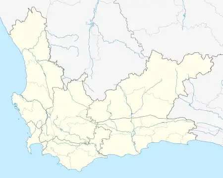
The residential suburb of Bellville lies approximately 23 kilometres (14.3 mi) north-east of Cape Town and 38 kilometres (23.6 mi) south-west of Paarl set amongst the Tygerberg Hills with views over the Cape Fold Mountains. Vehicle registrations in Bellville start with CY which also covers the Tygerberg areas of Durbanville, Parow and Goodwood.
Established
It was founded as "12 Mile Post" (Afrikaans: "12-Myl-Pos") because it is located 12 miles (20 km) from Cape Town city centre. It was first known as "Hardekraaltjie". Founded as a railway station on the line from Cape Town to Stellenbosch and Strand, it was renamed Bellville in 1861 after the surveyor-general Charles Bell.
Hospitals and educational institutes
The Karl Bremer Hospital functioned as the Academic Hospital for the University of Stellenbosch Medical School, but now the adjacent Tygerberg Hospital houses the medical school. Other hospitals in Bellville are: Mediclinic International Louis Leipoldt and Melomed.[2] The Cape Peninsula University of Technology, University of the Western Cape, University of Stellenbosch Business School and Northlink College are also situated in Bellville. D.F. Malan High School, Bellville High School, Westcliff School of Skills, The Settlers High School and Stellenberg High School are located in the area. Primary Schools are: Bellpark,[3] Bellville, Bellville-North, Boston, Eversdal,[4] Excelsior, Kenridge,[5] Mimosa, Totius,[6] Belville Islamic Primary School, Vredelust and Welgemoed.
Other places of interest

The Bellville Velodrome is located in the Tyger Valley area of Bellville. The Bellville Velodrome has an indoor cycling track and is next to the Bellville athletics track that used to host the annual MTBS athletics competition. Bellville Mall,[7] Tygervalley Shopping centre[8] and Willow Bridge[9] are shopping centres in Bellville. The last two shopping centres were built on the grounds that used to be a quarry and a jail.
Other sports an entertainment includes: Bellville library,[10] Bellville swimming pool[11] , Cool Runnings,[12] and PP Smit Sport fields[13]
Economy
Corporate headquarters
Bellville is one of the largest commercial nodes in the Greater Cape Town metropolis, home to several office and business parks with the most of the office space occupied in Bellville found in the Tyger Valley commercial node, north of the town.
The headquarters of several financial and insurance businesses, including South Africa’s largest insurance company Sanlam and its subsidiary Santam, as well as Momentum Metropolitan Holdings, are based in Bellville. Other large corporations based in the area include Pioneer Foods which is one of South Africa’s packaged goods company, Cipla South Africa (multinational pharmaceutical company), Medi-Rite (pharmaceutical retailer), Footgear (footwear company), Afrimat (mid-tier mining company) and the Bible Society of South Africa.[14][15]
Bellville is also home to South African government department regional head offices and municipal head offices especially for electricity and water services, including South African power utility, ESKOM’s Western Cape headquarters, City of Cape Town’s Electricity Services, City of Cape Town’s Water and Sanitation department and the Department of Water and Sanitation’s Western Cape headquarters.[16]
Geography
Location
Bellville lies in the centre of the northern suburbs of Cape Town with the boundaries of the town contiguous with Durbanville to the north, Parow to the west, Brackenfell to the east, Kuilsrivier to the southeast and Belhar to the south.
Topography
Bellville is both flat and hilly with the highest point in the town at the suburb of Welgemoed at approximately 310 m above sea level, perched high on the slopes of the Tygerberg Hills, north of the N1 highway. Other hilly parts of Bellville include the area from the eastern suburbs of Blommendal and Blomtuin stretching northwards across the N1 highway and the northern suburbs surrounding Bo-Oakdale, Tyger Valley, Ridgeworth, Stellenberg to Eversdal and Amanda Glen bordering with Durbanville.[17]
The rivers that flow through Bellville include the Elsieskraal River which flows southwards from the Tygerberg Hills in the northern outskirts of Bellville where it skirts the Tyger Valley commercial node, and Tyger Waterfront precinct, flows under the N1 highway to enter into the town centre and continuing westwards towards Parow and the Kuils River which skirts Bellville to the east and continues flows southwards and south-eastwards to Kuilsrivier.
Suburbs
Source:[18]
The Central Business District (CBD) or town centre of Bellville lies south of the N1 highway and is centred on two main roads, Voortrekker Road and Durban Road. The town centre contains several high-rise buildings and structures, with the Telkom communications tower being the notable structure in the skyline of the town.
The east of Bellville contains some of the town’s oldest and middle-class residential areas and one of the main industrial areas of the town, Stikland. The eastern suburbs of Bellville, including Oakdale, directly north of the town centre include Avondstil, Belgravia, Bellair, Blommendal. Blomtuin, Chrismar, Groenvallei, Harry de Villiers, Heemstede, Hillrise, Joubertsingel, Kempenville, Kingston, Labiance, La Rochelle, Laurindale, Loumar, Manieoord, Meyerhof, Oakglen, Runkel, Shirley Park, Stikland, Sunkist, Sunray, Thalmen, Vosfontein and Vredenburg
The north of Bellville, lying north of the N1 highway on rolling hills contains the most office space in the town concentrated in the Tyger Valley commercial node and the most affluent and least densely populated neighbourhoods in the town spreading up the hills to the Tygerberg Nature Reserve and bordering with the wine farms of Durbanville. The northern suburbs encompass Amanda Glen, Bellville Park, Bethanie, Bloemhof, Blomvlei, Bo-Oakdale, Danena, De Bron, Door de Kraal, East Rock, Eversdal, Glen Ive, Hoheizen, Kanonberg, Kenridge, Loevenstein, Oude Westhof, O’Kennedyville, Pascall, Protea Valley, Ridgeworth, Rosendal, Rosenpark, Selborne, Silverstream, Stellenberg, Stellenridge, Stellenryk, Van Riebeeckshof, Welgedacht, Welgemoed and Welgemoed Greens
The south of Bellville contains the highest densely populated neighbourhoods in the town and the highest concentration of industrialism within the town. In addition, it is home to two universities, University of the Western Cape and Cape Peninsula University of Technology, the second largest hospital in South Africa and the Tygerberg Hospital (it falls under Parow but is included in Bellville’s administrative boundaries). The southern suburbs of Bellville include Bellville South, Bellville South Industrial, Belrail, Blanc Kelly, Glenhaven, Mimosa, Sacks Circle Industrial and Triangle Farm.[19]
The west of Bellville contains the main public hospital in the town, Karl Bremer Hospital and some of the town’s oldest residential areas and typically classed as middle-class neighbourhoods, these include: Bellville West, Bosbell, Boston, Grahamdale, Joostenville and Vredelust.
Infrastructure
Rail Transport
Bellville is a major railway hub lying on the main commuter line between Cape Town and Wellington known as the Northern Line. The trains on this line serve areas such as Cape Town, Goodwood and Parow to the south-west and Brackenfell, Kraaifontein, Paarl and Wellington to the north-east. From the main Northern Line, the Strand Line branches off in Bellville south-east towards Kuilsrivier, Eersterivier, Stellenbosch (via Stellenbosch branch line), Somerset West and Strand.
As a major industrial hub within the Cape metropolitan region, it is also a major hub for Transnet Freight Rail, specifically in the Western Cape with a large depot south of the CBD along Robert Sobukwe Road.[20]
Road Transport
The N1 is the major freeway that runs through Bellville, roughly running SW to NE from Cape Town to Paarl, separating Bellville Central from Bellville’s northern suburbs. The R300 (Kuils River Freeway) is a freeway in the east of Bellville starting at an interchange with the N1, and continues south along the eastern boundary towards Cape Town International Airport and Mitchells Plain.
The R101 starts at the intersection with the M30 and runs roughly east–west from Bellville to Brackenfell as Old Paarl Road. The R102 roughly runs east–west from Parow to Kuilsrivier and runs through Bellville as Voortrekker Road (in Bellville Central) and Strand Road. The R302 roughly runs north–south from Durbanville to Bellville Central as Durbanville Avenue and Durban Road.
Bellville is also served by a number of metropolitan routes linking it to surrounding towns in the Greater Cape Town region. The M10 links Bellville with Cape Town International Airport to the south. The M16 links Bellville with Durbanville to the north and Tygerberg Hospital to the south. The M23 links Bellville with Stellenbosch to the south-east. The M25 links Bellville with Brackenfell to the east. The M31 links Bellville with Durbanville to the north. The M73 links Bellville with Brackenfell to the east. The M124 links Bellville with Durbanville to the north. The M171 links Bellville with Delft to the south.
Bellville is also served internally by metropolitan routes including the M11 (provides a bypass to the south of Bellville Central), M30, M121 and M189.
Parks and Recreation
Bellville contains several public parks and recreational dams within its neighbourhoods most notably the Jack Muller Danie Uys Park in Boston, north of the town centre where the Parkrun Bellville takes place every Saturday, Majik Forest on the northern outskirts of Bellville, Door de Kraal Dam in the north of Bellville and Rosendal Dam in the north of Bellville.[21] In addition, the Tygerberg Nature Reserve is set above Bellville on the Tygerberg Hills to the north-west and offers scenic views across the Greater Cape Town metropolitan area.[22]
Golf is also one of the main recreational activities performed in Bellville with the Bellville Golf Club being the main golf course in the town, lying on the slopes of the northern suburb of Welgemoed and the Golf Village Tygervalley, a driving range in Tyger Valley.[23][24]
Constituency
The town was a constituency in the Cape Peninsula, Cape Town, Cape Province in the South African House of Assembly starting in 1933. The first elected member was FHP Creswell (b. 13 November 1866, d. 28 August 1948).[25][26] In 1939 it was not a constituency any more. In 1953 it regained constituency status and JFW Haak won. Haak retained this until 1970, when Louis Pienaar took over from him. In 1975 AT van der Merwe took over from him.[27]
Municipality
Bellville was a municipality from 1940 to 1996, and was given the status of a city on 7 September 1979.
Mayors of Bellville
- 1940–1943 van Niekerk, Andries Joseph (born 14 May 1882, died 30 April 1953) married Athalia Solms (born 4 August 1876)
- 1943–1944 Blanckenberg, Josias Jacobus (born 10 March 1907, died 21 October 1992)
- 1944–1949 van Niekerk, Andries Joseph. Second term see no 1
- 1949–1950 Haak, Jan Friedrich Wilhelm (born 20 April 1917, died 16 February 1993) married Maria Smuts Theron (born 1 August 1917). Jan Haak was also the Minister of Economy in the South African Government from 1967 to 1970.[28][29] He was also as member of the National Party, representing Bellville in Parliament.[30][31]
- 1950–1952 Duminy, Hendrik Cornelis van Niekerk (born 6 September 1899, died 29 March 1974) married Frieda Moolman.
- 1952–1953 Sacks, Alec (born 14 April 1913.,died 29 May 1974) married Anita Joseph(born 15 March 1922)
- 1953–1954 West, Adam Johannes (born 7 August 1905, died 30 November 1983) married Maria Margaretha Visser. AJ West Street in Boston Bellville is named after him.
- 1954–1956 Barnard, Johannes Hendrik (born 3 September 1891, died 17 October 1956) married Lucia Ruth Mosel. Barnard Street in Oakdale Bellville is named after him.
- 1956–1958 Meyer, Petrus Hendrik (born 7 September 1926) married Stephanie Swart (born 20 November 1926)
- 1958–1961 van Riet, Willem Frederik (born 11 July 1910, died 9 December 1988) married Augusta Dorothy de Villiers (born 31 August 1909)
- 1961–1963 Pienaar, Michiel Hendrik de Wet (born 12 October 1900) married Anna Susanna Siebrits(born 22 May 1904) Mike Pienaar Boulevard in Bellville West is named after him.
- 1963–1966 Bezuidenhout, Willem Johannes (born 12 October 1900) married Mona Havenga (born 12 January 1903). Bill Bezuidenhout Avenue in Blomtuin Bellville is named after him.
- 1966–1969 Pienaar, Michiel Hendrik de Wet.Second term see no 11
- 1969–1971 Smit, Pieter Philip (born 8 March 1917, died 10 October 1997). The PP Smit sport fields in Durban Road Bellville is named after him.
- 1971–1973 Meyer, Martinus Daniel (born 21 June 1918) married Mary Elizabeth Weidemann (born 18 July 1925) . Tienie Meyer Bypass is named after him.
- 1973–1975 de Jager, Josephus Jacobus (born 9 December 1912, died 7 July 2000) married Helena Claudina Nel(born 8 August 1912). Jip de Jager Drive in Welgemoed Bellville is named after him.
- 1975–1977 Uys, Daniel(born 3 June 1932) married Beatrix Hendina Moorrees (born 5 September 1934). Danie Uys Park in Boston Bellville is named after him.
- 1977–1978 van Schoor, Daniel Willem Jacobus (born 31 March 1935, died 14 August 2001) married Johanna Elizabeth Coetzee (born 2 September 1937). Willie van Schoor Drive in Bellville is named after him.
- 1978–1979 de Jager, Josephus Jacobus. Second term see no 16
- 1979–1981 Meyer, Martinus Daniel Second term see no 15
- 1981–1983 Pienaar, Kristo Johannes (born 4 July 1922, died 6 April 1996) married Christina Wilhelmina van Rooyen (born 24 May 1921)
- 1983–1985 Uys, Daniel. Second term see no 17
- 1985–1986 Kleynhans, PH
- 1986–1987 Meyer, Martinus Daniel. Third term see no 15
- 1987–1989 Pienaar, Kristo Johannes. Second term see no 21
- 1989–1991 van Schoor, Daniel Willem Jacobus. Second term see no 18
- 1991–1994 Kempen, Abraham Petrus de Villiers (born 23 March 1920, died 29 June 2010) married Bramie Joubert (born 18 December 1919). The Awie Kempen Vehicle Testing Grounds is named after him.
- 1994–1996 Cronje, Carl Peter Roche (born 10 July 1932, died 2 November 2018) married Miriam Lauretta Sadie.(born 7 April 1933). Carl Cronje Drive is named after him.
In April 1982 P. W. Botha received honorary citizenship of the city.

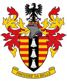
Coat of arms
The municipal council assumed a coat of arms on 18 June 1947.[32] It later altered the arms, three times, before settling on the final version in 1979. The shield was divided into twelve horizontal bars of red and gold, representing the original village name of "Twaalfmyl". A black vertical band ("pale") down the centre displayed two silver hawk's bells, between which was a small blue shield displaying a golden sheaf of wheat. The crest was a black eagle, and the motto Prendre sa belle. Some time later, the blue shield was removed, and the wheatsheaf was placed directly on the black pale. In 1957, the wheatsheaf was replaced with a third hawk's bell. This version of the arms, re-drawn by Ivan Mitford-Barberton, was registered with the Cape Provincial Administration in February 1959.[33]
The final version of the arms, as amended by Cornelis Pama in 1979, replaced the hawk's bells with church bells.[34] In this form, the arms were registered at the Bureau of Heraldry in February 1980.[35] The registered blazon was : Barry of twelve Gules and Or, on a pale Sable three church bells Argent.
Media
- In May 2007, Meg Ryan and William H. Macy completed the last day of photography for their movie, The Deal, at the Bellville Civic Centre.
- The novel 2 Dae in Mei (English: 2 Days in May) by Jaco Fouché takes place in Bellville.[36]
Notable people
References
- "Main Place Bellville". Census 2011.
- "Melomed private hospital". Retrieved 25 April 2018.
- "Bellpark Primary". Retrieved 25 April 2018.
- "Eversdal Primary". Retrieved 25 April 2018.
- "Kenridge Primary". Retrieved 25 April 2018.
- "Laerskool Totius (Translated Totius Primary)". Retrieved 25 April 2018.
- "Bellville Mall". Retrieved 25 April 2018.
- "Tyger Valley". Retrieved 25 April 2018.
- "Willow Bridge". Retrieved 25 April 2018.
- "Bellville Public Library". Retrieved 25 April 2018.
- "Bellville Swimming Pool". Retrieved 25 April 2018.
- "Cool Runnings". Retrieved 25 April 2018.
- "PP Smit Sports Grounds". Retrieved 25 April 2018.
- "Office Locations". Cipla South Africa. Retrieved 24 March 2023.
- "Contact us". www.biblesociety.co.za. Retrieved 24 March 2023.
- "Water and sanitation report" (PDF). dws.gov.za. Retrieved 10 May 2023.
- "Bellville topographic map, elevation, terrain". Topographic maps. Retrieved 24 March 2023.
- "Census 2011: Main Place: Bellville: Map". census2011.adrianfrith.com. Retrieved 24 March 2023.
- "Tygerberg Hospital: Overview | Western Cape Government". www.westerncape.gov.za. Retrieved 24 March 2023.
- Overview transnetfreightrail-tfr.net
- "Jack Muller Park". Retrieved 25 April 2018.
- "home | Bellville parkrun | Bellville parkrun". www.parkrun.co.za. Retrieved 24 March 2023.
- "Tygervalley Driving Range | Golf in Cape Town | Golf Village | Mini Golf". Retrieved 10 May 2023.
- "Home". Bellville Golf Club. Retrieved 24 March 2023.
- Frederick Hugh Page Cresswell, Retrieved 25 April 2018
- van der Poel, J. (5 April 2007). Selections from the Smuts Papers: Volume 5, September 1919 – November 1934. Cambridge University Pressdate= 5 April 2007. ISBN 9780521033688.
- Schoeman, B.M. 1977. Parlementêre verkiesings in Suid-Afrika 1910–1976. Pretoria: Aktuele Publikasies
- Bellville Kiesafdeling (Bellville Ward), Retrieved 25 April 2018
- "HAAK, Jan Friedrich Wilhelm Inventory of documents". UFS.
- Jan Haak, Retrieved 25 April 2018
- Pfiser,R. (July 2005). South Africa and African States: From Pariah to Middle Power, 1962–1994. I.B.Tauris. ISBN 9781850436256.
- Western Cape Archives : Bellville Municipal Minutes (18. June 1947).
- Cape of Good Hope Official Gazette 2957 (6 February 1959).
- Strydom, C.J.S. (1981). Bellville'– Wordingsjare van 'n Stad :: Growth of a City.
- "National Archives of South Africa : Data of the Bureau of Heraldry". Retrieved 25 April 2018.
- "Read an Excerpt from Twee Dae in Mei (Translated two days in May)". Retrieved 25 April 2018.
External links
Communities of City of Cape Town Metropolitan Municipality, Western Cape | |||||
|---|---|---|---|---|---|
Seat: Cape Town | |||||
| Atlantic Seaboard | .svg.png.webp) City of Cape Town within South Africa | ||||
| Blaauwberg | |||||
| Cape Flats |
| ||||
| City Centre | |||||
| Helderberg | |||||
| Northern Suburbs | |||||
| Southern Suburbs | |||||
| South Peninsula | |||||