Blue Hole (New Mexico)
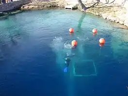
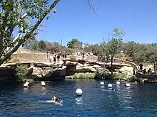
The Blue Hole of Santa Rosa, or simply the Blue Hole, is a circular, bell-shaped pool or small lake located along Route 66 east of Santa Rosa, New Mexico that is a tourist attraction and swimming venue, and one of the most popular dive destinations in the US[1] for scuba diving and training. The Blue Hole is an artesian well and cenote that was once used as a fish hatchery.[2]
| Blue Hole New Mexico | |
|---|---|
 | |
 Blue Hole New Mexico  Blue Hole New Mexico | |
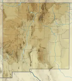
| Location | Guadalupe County, near Santa Rosa, New Mexico |
| Coordinates | 34.940447°N 104.673239°W |
| Basin countries | United States |
| Max. width | 80 ft (24 m) |
| Max. depth | >80 ft (24 m) |
| Surface elevation | 4,600 ft (1,400 m) |
| Frozen | never |
| Islands | none |

Description
The Blue Hole is a clear blue body of water with a constant 62 °F (17 °C) temperature and constant inflow of 3,000 US gallons per minute (11 m3/min; 2,500 imp gal/min), enough to cycle out the water every six hours. While the surface is only 80 feet (24 m) in diameter, it expands to a diameter of 130 feet (40 m) at the bottom. The depth of the main pool is more than 80 feet (24 m) below the surface.[3] The water in the pool originates deep underground below 200 feet (61 m) from the western edge of the Ogallala Aquifer.[4]
The Blue Hole is an example of a natural artesian well, a type of well or spring fed by water under high pressure, and of a cenote, a collapsed cavern exposing groundwater beneath. The cavern was formed by the dissolution of the limestone bedrock by groundwater, carving caverns into the rock until the roof caved in.[5]
At the bottom are large boulders, rubble, bones, masks, a crucifix, and other objects, and the entrance to a labyrinth of cave passages and rooms. The caves extend down to 194 feet (59 m), where they end in a cavern with a rubble-choked floor. The source water for the pool rushes up from the rubble in the floor of this cavern. Beneath this may be more passages.[5] One local legend states that the passages may be connected to Carlsbad Caverns, one of the longest explored cave systems in the United States; however, the surface entrance to that cave system is located over 200 miles to the south.[6]
Since 1976, the cave passages have been sealed off to the public by a metal grate installed by the city to prevent access by inexperienced divers. It was only allowed to be unsealed for mapping between 2013 and 2016 by the ADM Exploration Foundation, an experienced cave exploration group. Hazards in the passages include frequent cave-ins, zero visibility due to silt, and extreme restrictions.[5]
Fauna present in the Blue Hole includes goldfish, koi, carp, and crawdads.[7]
Since Santa Rosa, New Mexico is at an elevation of 4,616 ft (1,407 m), it is necessary for divers to use high-altitude dive tables to compute the dive profile and decompression stops when diving in the Blue Hole.
At the site are a visitors center, divers' locker rooms, a conference center, picnic tables, restrooms, a diving platform, and a short wall surrounding the pool to prevent surface runoff from fouling the clarity of the water. The pool is open for public use, including picnic, swimming, diving, and snorkeling; however, there are no lifeguards on duty.
History
Early history
The Blue Hole was used by nomadic tribes as a reliable water source in the arid plains that surround the area. Cowboys on cattle drives across the Pecos River would also stop by the pool. When Route 66 came through the city in the 1920s, the original alignment brought it right past the property of the Blue Hole. The pool became a popular stop and tourist attraction for motorists on the new highway. In 1932, it became a hatchery for the National Fish Hatchery. Afterward it became the Blue Hole Recreation Area in the 1970s, then the Blue Hole Dive and Conference Center. In the current era of the Interstate, the pool continues to be a popular destination with both locals and divers from around the world.[8]
1976 Recovery operation
During their searches for a missing diver in late winter and early spring of 1976, rescue divers with the New Mexico State Police crudely mapped part of the then-unexplored cave system and noted the discoveries within. They reportedly reached a depth of 225 feet (69 m), but that "this number would be closer to 190’ as the divers were not using depth gauges that were adjusted for altitude".[5] At the entrance, they encountered a tight restriction that required removing equipment to access, and the exhaust from their SCUBA equipment dislodged rocks and caused cave-ins. One room was reported at 17 feet (5.2 m) above the cave floor, but collapsed as they occupied it; one of the divers was struck and nearly trapped by a falling boulder 3 feet (0.91 m) in diameter.[9]
When the divers accessed the second room, they noted formations such as shafts, cracks, and crevasses in the ceiling of the cavern. Another room they explored, dubbed the "Tee-Pee Room", had a ceiling that "looks as though thousands of ice cream cones were hanging invertly", as noted by Police diver Tom Hawkins.[9] Hawkins also stated of the caves:
“When I went down to the third chamber, I was using a 100,000 candle-power flashlight[...] I could see easily in the chamber, but I couldn’t see to the other side — or the bottom — of the third chamber. Just imagine yourself in Carlsbad Cavern, but filled with water and without light.”[9]
After the recovery operation, the city of Santa Rosa sealed the entrance with a 3 foot (0.91 m) diameter duct and grate "snorkel pipe" in April to prevent future access to the caverns. Moreover, the Army Corps of Engineers dumped two truckloads of rock and debris into the grate, apparently without the knowledge of city officials.[5][9]
ADM expeditions
In 2013, the ADM Exploration Foundation and the city fielded an exploration expedition to explore and map the cave system. With permission from the city, the expedition team removed the snorkel pipe to gain access to the first cavern. However, the lack of previous knowledge of the debris dumped into the grate by the army prevented further exploration. Although the team were able to remove tons of rock and debris from the cavern floor significantly increasing the water discharge rate, they ultimately "were thwarted by one lone boulder choking the entrance to the second room".[5]
After the expedition, the city installed another grate to prevent access to the exposed cave entrance.[5] Over the next three years, the team worked with state police and APD divers to dredge and remove the remaining debris and open up the passages.[10]
In March 2016 the ADM team returned for another expedition to map and explore the entirety of the cave system. The team explored down to a depth of 194 feet (59 m), where the water was found filtering up through tons of rock debris covering the cavern floor. Another fatality occurred during this expedition, outlined in the next section of this article. After the expedition, the team announced that all accessible areas of the system have been explored and mapped, and recommended to the city that the entrance remain closed to the public.[10]
Once again, the city installed a snorkel pipe to prevent further access. As of March 2021, no one has entered the caves since the expedition.[10]
Incidents
On March 10, 1976, a team of student divers from Oklahoma were training in the pool when two divers became separated from the group and failed to surface. State Police rescue divers began a search of the unexplored caves and on the first day, they found a body in the first chamber. Divers continued searching the passages for the next six weeks until the second body was found deep within the cave system. This incident prompted the city to seal the caves from the public.[5][9]
On March 26, 2016, 43-year-old California diver Shane Thompson, a Navy veteran from the ADM Exploration Foundation with over 20 years of diving experience, including search and rescue and recovery operations, was exploring passageways when he became separated from his partner Mike Young after their tether broke. After taking a wrong turn in low visibility, Thompson became trapped in a dead end passage 160 feet (49 m) below the surface. By the time Young had located Thompson, he had already drowned. Young returned the next day to recover the body.[11]
See also
- List of sinkholes of the United States
- Bottomless Lakes State Park, similar water bodies also in New Mexico
References
- Sachs, Andrea (December 19, 2004). "On Route 66, the Blue Hole Beckons (washingtonpost.com)". The Washington Post. Retrieved December 6, 2008.
- "Scuba Diving in Santa Rosa Blue Hole New Mexico". santarosabluehole.com. Retrieved August 23, 2020.
- "Santa Rosa, New Mexico : City of Lakes". Archived from the original on December 7, 2008. Retrieved December 6, 2008.
- Main, Douglas (September 13, 2013). "Divers hope to unlock secrets of underwater cave closed for years". ABC News. Retrieved March 10, 2021.
- "ADM Blue Hole Expedition". Retrieved March 9, 2021.
- Vigneron, Peter. "Into the Deep: Diving New Mexico's Blue Hole". Dorado Magazine. Retrieved March 10, 2021.
- "Blue Hole State Park in Santa Rosa, New Mexico". Travel Tips. USA Today. Retrieved March 10, 2021.
- "About the Santa Rosa Blue Hole New Mexico". City of Sant Rosa. Retrieved March 10, 2021.
- "The little-known tragedy of the Blue Hole". Route 66 News. Retrieved March 10, 2021.
- Associated Press (March 31, 2016). "No more exploration planned at famed Blue Hole". San Diego Tribune. Retrieved March 10, 2021.
- "Veteran scuba diver dies in underwater cave accident in New Mexico". The Guardian. March 31, 2016. Retrieved January 29, 2020.