Brandon, Montana
Brandon is an unincorporated community and census-designated place (CDP) in Madison County, Montana, United States. It is in the northwestern part of the county, at the western base of the Tobacco Root Mountains, in the valley of Mill Creek. Via Mill Creek Road it is 3 miles (5 km) southwest to Sheridan in the Ruby Valley.
Brandon, Montana | |
|---|---|
 Brandon  Brandon | |
| Coordinates: 45°28′3″N 112°8′23″W | |
| Country | United States |
| State | Montana |
| County | Madison |
| Area | |
| • Total | 0.44 sq mi (1.15 km2) |
| • Land | 0.44 sq mi (1.15 km2) |
| • Water | 0.00 sq mi (0.00 km2) |
| Elevation | 5,609 ft (1,710 m) |
| Population (2020) | |
| • Total | 46 |
| • Density | 103.84/sq mi (40.13/km2) |
| Time zone | UTC-7 (Mountain (MST)) |
| • Summer (DST) | UTC-6 (MDT) |
| ZIP Code | 59749 (Sheridan) |
| Area code | 406 |
| FIPS code | 30-09400 |
| GNIS feature ID | 2806642[2] |
Brandon was first listed as a CDP prior to the 2020 census.[2]
References
- "ArcGIS REST Services Directory". United States Census Bureau. Retrieved September 5, 2022.
- "Brandon Census Designated Place". Geographic Names Information System. United States Geological Survey, United States Department of the Interior.
- "Census of Population and Housing". Census.gov. Retrieved June 4, 2016.
Municipalities and communities of Madison County, Montana, United States | ||
|---|---|---|
| Towns | 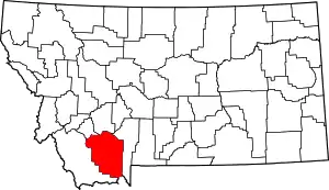 Madison County map | |
| CDPs | ||
| Other communities | ||
| Ghost towns | ||
| Footnotes | ‡This populated place also has portions in an adjacent county or counties | |
This article is issued from Wikipedia. The text is licensed under Creative Commons - Attribution - Sharealike. Additional terms may apply for the media files.