Brewer, Missouri
Brewer is an unincorporated community and census-designated place in Saline Township, Perry County, Missouri, United States, which is located northwest of Perryville.
Brewer, Missouri | |
|---|---|
 Location of Perry County | |
| Coordinates: 37°46′51″N 89°55′31″W | |
| Country | United States |
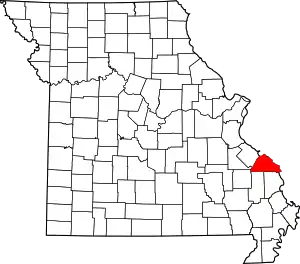
| State | Missouri |
| County | Perry |
| Township | Saline |
| Area | |
| • Total | 2.34 sq mi (6.06 km2) |
| • Land | 2.34 sq mi (6.06 km2) |
| • Water | 0.00 sq mi (0.00 km2) |
| Elevation | 584 ft (178 m) |
| Population (2020) | |
| • Total | 361 |
| • Density | 154.34/sq mi (59.58/km2) |
| Time zone | UTC-6 (Central (CST)) |
| • Summer (DST) | UTC-5 (CDT) |
| ZIP code | 63775[3] |
| Area code | 573 |
| FIPS code | 29-08272[4] |
| GNIS feature ID | 714672[2] |
History
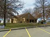
Christ the Savior Catholic Church
Brewer was named for R. M. Brewer.[5] The Brewer family, originally hailing from Maryland, had settled in Spencer County, Kentucky, before eventually coming to Missouri.
The town was unofficially known as Brewerville before the post office was christened Brewer in 1886.[6]
References
- "ArcGIS REST Services Directory". United States Census Bureau. Retrieved August 28, 2022.
- U.S. Geological Survey Geographic Names Information System: Brewer, Missouri
- Findpincode.com: Postal Code Brewer, MO http://findpincode.com/brazeau-missouri-zip-code-postal-code-63737.html%5B%5D
- "Brewer (Perry County, Missouri [MO]): Miscellaneous Information". www.roadsidethoughts.com. Archived from the original on July 2, 2013. Retrieved January 26, 2022.
- Eaton, David Wolfe (1917). How Missouri Counties, Towns and Streams Were Named. The State Historical Society of Missouri. pp. 338.
- The State Historical Society of Missouri: Perry County http://shs.umsystem.edu/manuscripts/ramsay/ramsay_perry.html
- "Census of Population and Housing". Census.gov. Retrieved June 4, 2016.
Municipalities and communities of Perry County, Missouri, United States | ||
|---|---|---|
| Cities | Map of Missouri highlighting Perry County | |
| Village | ||
| Townships | ||
| CDPs | ||
| Other communities | ||
| Abandoned villages | ||
| Footnotes | ‡This populated place also has portions in an adjacent county or counties | |
This article is issued from Wikipedia. The text is licensed under Creative Commons - Attribution - Sharealike. Additional terms may apply for the media files.