Brookfield Center, Connecticut
Brookfield Center is a census-designated place (CDP) in the town of Brookfield, Fairfield County, Connecticut, United States. It includes the 43-acre (17 ha) Brookfield Center Historic District around the intersection of Connecticut Routes 25 and 133, as well as surrounding residential neighborhoods.
Brookfield Center, Connecticut | |
|---|---|
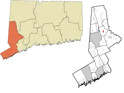 Location within the Western Connecticut Planning Region and the state of Connecticut | |
 Brookfield Center  Brookfield Center | |
| Coordinates: 41°27′56″N 73°23′15″W | |
| Country | |
| State | Connecticut |
| County | Fairfield |
| Town | Brookfield |
| Area | |
| • Total | 1.32 km2 (0.51 sq mi) |
| • Land | 1.32 km2 (0.51 sq mi) |
| • Water | 0.0 km2 (0.0 sq mi) |
| Elevation | 151 m (495 ft) |
| Time zone | UTC-5 (Eastern (EST)) |
| • Summer (DST) | UTC-4 (EDT) |
| ZIP Code | 06804 (Brookfield) |
| Area code(s) | 203/475 |
| FIPS code | 09-08910 |
| GNIS feature ID | 2805933[2] |
Brookfield Center was first listed as a CDP prior to the 2020 census.
References
- "2020 U.S. Gazetteer Files – Connecticut". United States Census Bureau. Retrieved April 12, 2021.
- "Brookfield Center Census Designated Place". Geographic Names Information System. United States Geological Survey, United States Department of the Interior.

This article is issued from Wikipedia. The text is licensed under Creative Commons - Attribution - Sharealike. Additional terms may apply for the media files.