Buiratau National Park
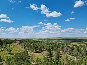
Buiratau National Park (Kazakh: Бұйратау ұлттық паркі, Būiratau ūlttyq parkı) or Buyratau National Nature Park was created in 2011 to preserve a unique transitional zone between dry steppe and semi-arid forest ecosystems of the Kazakh Uplands of central Kazakhstan. The park is located in the Yereymentau Mountains, straddling the border of Yereymentau District of Akmola Region (60,815 hectares (150,277 acres; 608 km2; 235 sq mi)), and Sarybel District of Karaganda Region (28,154 hectares (69,570 acres; 282 km2; 109 sq mi)), and is about 60 km east of the capital city of Astana.[1]
| Buiratau National Park | |
|---|---|
| (alt: Buyratau National Park) | |
 | |
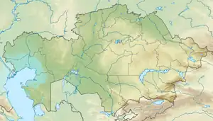
 Location of park in Kazakhstan | |
| Location | Yereymentau Mountains Akmola Region, Karaganda Region |
| Nearest city | Astana |
| Coordinates | 51°20′N 73°20′E |
| Area | 88,968 hectares (219,845 acres; 890 km2; 344 sq mi) |
| Established | 2011 |
| Governing body | Committee of Forestry and Fauna of the Ministry of Agriculture, Kazakhstan |
| Website | http://gnpp-buiratau.kz/en |
Topography
The area is dry steppe in the north, with more forest in the hills to the south and stands of alder and birch along the streams. The relief is low ridges and hills of the Yereymentau Mountains, with inter-mountain plains. There are many closed basins with very shallow (less than 1 meter) salt lakes; fresh groundwater can be found at depths of 1 – 17 meters. The largest lakes are Bozaigyr (Бозайгыр) and Azhybai (Ажыбай).[2][3]
The park was formed by combining the original core reserve with the former Belodymov Zoological Park and the former Yereymentau Nature Reserve.[3]
Climate
The climate is "Cold Semi-Arid Climate" (Köppen Classification BSk: warm, dry summers with cold winters. 280 mm of precipitation per year (maximum in summer). Average temperature ranges from −16 °C (3 °F) in January to 20 °C (68 °F) in July.[4] [5]
Plants and animals
In addition to the relic forests, common plants of the area include scrub Siberian pea-tree (Caragana arborescens) and feather grass (Stipa).[6] Scientists have recorded over 450 species of vascular plants in the park, representing 20% of the species of the Central Kazakh Uplands.
The area is also known for Yereimantau Wild Sheep, supporting approximately 200 individuals. 45 species of mammals have been recorded in the area, and 227 species of birds.[1]
Tourism
There are four tourist routes in the park; individual and group tours are offered in the summer. A small admission fee is charged at the entrance.[7]
References
- "Buiratau, A New National Park Established in Kazakhstan". Kazinform. Kazinform International News Agency. Retrieved 29 May 2017.
- "Ereymentau Mountains". IBA Data Zone. Birdlife International. Retrieved 29 May 2017.
- "About Our Park". Buiratau National Park (official site). Buiratau Park Management. Retrieved 29 May 2017.
- M. Kottek; et al. "Koeppen" (PDF). World Map of the Koeppen-Gieger Climate Classification, Updated. Meteoroligische Zeitschrift, June 2006. Retrieved 2015-08-01.
- "Climate - Ereymentau". Protected Areas. GlobalSpecies.Org. Archived from the original on 19 August 2017. Retrieved 21 May 2017.
- Marinus, JA (14 June 2012). Eurasian Steppes. Ecological Problems and Livelihoods in a Changing World. Springer Science. ISBN 9789400738867. Retrieved 29 May 2017.
- "Tourist Routes". Buiratau National Park (official site). Buiratau Park Management. Retrieved 29 May 2017.
External links
 Media related to Buyratau national park at Wikimedia Commons
- Buiratau National Park on OpenStreetMap
- Bird-watching shelter at Azhybai lake