Bujesily
Bujesily (German: Bujesil) is a municipality and village in Rokycany District in the Plzeň Region of the Czech Republic. It has about 80 inhabitants.
Bujesily | |
|---|---|
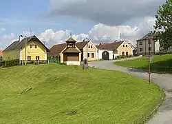 Centre of Bujesily | |
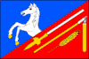 Flag 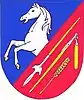 Coat of arms | |
 Bujesily Location in the Czech Republic | |
| Coordinates: 49°54′53″N 13°34′28″E | |
| Country | |
| Region | Plzeň |
| District | Rokycany |
| First mentioned | 1227 |
| Area | |
| • Total | 6.20 km2 (2.39 sq mi) |
| Elevation | 345 m (1,132 ft) |
| Population (2023-01-01)[1] | |
| • Total | 76 |
| • Density | 12/km2 (32/sq mi) |
| Time zone | UTC+1 (CET) |
| • Summer (DST) | UTC+2 (CEST) |
| Postal code | 331 41 |
| Website | www |
Geography
Bujesily is located about 19 km (12 mi) north of Rokycany and 22 km (14 mi) northeast of Plzeň. It lies in the Plasy Uplands. The highest point is the Skalka hill at 397 m (1,302 ft) above sea level. The Berounka River forms the northern municipal border, and the Radnický Stream, its right tributary, forms the eastern border. The Bujesilský Brook is a short stream that drains the area of the village.
The village lies on a plateau above the deep valley of the Berounka. The canyon of the Berounka is lined with forest while the area around the village is mostly forestless.
History
The first written mention of Bujesily is from 1227.[2]
Demographics
|
|
| ||||||||||||||||||||||||||||||||||||||||||||||||||||||
| Source: Censuses[3][4] | ||||||||||||||||||||||||||||||||||||||||||||||||||||||||
Transport
Bujesily is accessible by a local road linked to the II/232 road from Rokycany to Kozojedy.
Sights
There are two protected cultural monuments: a wooden belfry in the centre of the village and the homestead No. 10 from the mid-19th century.[5]
References
- "Population of Municipalities – 1 January 2023". Czech Statistical Office. 2023-05-23.
- "O obci" (in Czech). Obec Bujesily. Retrieved 2022-09-30.
- "Historický lexikon obcí České republiky 1869–2011 – Okres Rokycany" (in Czech). Czech Statistical Office. 2015-12-21. pp. 1–2.
- "Population Census 2021: Population by sex". Public Database. Czech Statistical Office. 2021-03-27.
- "Výsledky vyhledávání: Kulturní památky, obec Dolní Domaslavice". Ústřední seznam kulturních památek (in Czech). National Heritage Institute. Retrieved 2023-06-13.