Mýto
Mýto (Czech pronunciation: [ˈmiːto]; German: Mauth) is a town in Rokycany District in the Plzeň Region of the Czech Republic. It has about 1,600 inhabitants.
Mýto | |
|---|---|
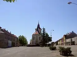 Town square | |
 Flag  Coat of arms | |
 Mýto Location in the Czech Republic | |
| Coordinates: 49°47′21″N 13°44′5″E | |
| Country | |
| Region | Plzeň |
| District | Rokycany |
| First mentioned | 1296 |
| Government | |
| • Mayor | František Končel |
| Area | |
| • Total | 17.80 km2 (6.87 sq mi) |
| Elevation | 443 m (1,453 ft) |
| Population (2023-01-01)[1] | |
| • Total | 1,558 |
| • Density | 88/km2 (230/sq mi) |
| Time zone | UTC+1 (CET) |
| • Summer (DST) | UTC+2 (CEST) |
| Postal code | 338 05 |
| Website | www |
Etymology
The town's name literally means "toll". It refers to its history and location on an important trade route from Prague to Bavaria where the toll was collected.[2]
Geography
Mýto is located about 11 km (7 mi) northeast of Rokycany and 24 km (15 mi) east of Plzeň. The municipal territory extends into three geomorphological regions. The central part with the built-up area lies in the western tip of the Hořovice Uplands. The southern part lies in the Brdy Highlands and includes the highest point of Mýto, the hill Ostrý vrch at 641 m (2,103 ft) above sea level. A small part in the north lies in the Křivokrát Highlands.
The Holoubkovský Stream flows through the town. The streams supplies two notable bodies of water in the municipal territory, the Štěpánský and Podmýtský ponds.
History
The first written mention of Mýto and its older church is from 1296. The original settlement was located on a hill around the Church of Saint Stephen. Gradually people began to settle in the area of today's Mýto, where the Church of Saint John the Baptist was built in 1350. At the beginning of the 14th century Mýto became a market town, and in 1905 it became a town.[2]
Demographics
|
|
| ||||||||||||||||||||||||||||||||||||||||||||||||||||||
| Source: Censuses[3][4] | ||||||||||||||||||||||||||||||||||||||||||||||||||||||||
Transport
The D5 motorway passes through the northern part of the territory.
Mýto is located on a regional railway line leading from Beroun to Plzeň and Klatovy.[5]
Sights

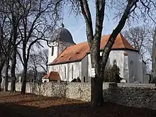
The Gothic Church of Saint Stephen was built in the 13th century and its Baroque tower dates from the 18th century. Today it serves social and cultural purposes.[2]
The Church of Saint John the Baptist was originally a chapel consecrated to John the Evangelist. During the Thirty Years' War the church was burned down, and in 1680–1682 it was built once again. Many of its Gothic elements were rebuilt in the Baroque style.[2]
Notable people
- August Wilhelm Ambros (1816–1876), Austrian music historian
References
- "Population of Municipalities – 1 January 2023". Czech Statistical Office. 2023-05-23.
- "Historie města" (in Czech). Město Mýto. Retrieved 2021-06-18.
- "Historický lexikon obcí České republiky 1869–2011 – Okres Rokycany" (in Czech). Czech Statistical Office. 2015-12-21. pp. 5–6.
- "Population Census 2021: Population by sex". Public Database. Czech Statistical Office. 2021-03-27.
- "Detail stanice Mýto" (in Czech). České dráhy. Retrieved 2023-08-15.
- "Gäste aus tschechischer Partnerstadt zu Besuch in Berga". otz.de (in German). Ostthüringer Zeitung. 2019-07-16. Retrieved 2020-08-02.