Byford, Western Australia
Byford is a suburb on the south-eastern edge of Perth, Western Australia, within the Shire of Serpentine-Jarrahdale. The town has its origins in a township that was gazetted under the name "Beenup" in 1906. In 1920, the name of the township was changed to Byford.[2]
| Byford Perth, Western Australia | |||||||||||||||
|---|---|---|---|---|---|---|---|---|---|---|---|---|---|---|---|
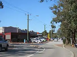 George Street, Byford, in August 2022 | |||||||||||||||
| Coordinates | 32.222°S 116.001°E | ||||||||||||||
| Population | 18,878 (SAL 2021)[1] | ||||||||||||||
| Postcode(s) | 6122 | ||||||||||||||
| Area | 22 km2 (8.5 sq mi) | ||||||||||||||
| Location | |||||||||||||||
| LGA(s) | Shire of Serpentine-Jarrahdale | ||||||||||||||
| State electorate(s) | Darling Range | ||||||||||||||
| Federal division(s) | Canning | ||||||||||||||
| |||||||||||||||
Toponym
The original name of Byford was 'Beenup'. "Beenup", a corruption of the Aboriginal name associated with nearby Beenyup Brook, was the spelling that had been applied to a railway siding there. The uncorrupted form, "Bienyup" received mention in surveyor Robert Austin's account of an expedition through the area in 1848.[3] On April 23, 1920, the name of the township was changed to Byford.[2] Byford was chosen through a ballot which included other names such as Beenup, Beenyup, Glengeorge and Winterbourne.[4]
History
Colonial period and early 20th century
Little has been documented of the Aboriginal occupation of the Byford area, but material traces of the district's original inhabitants have been found in numerous locations. The foothills were on the periphery of Thomas Peel's 1834 land grant, and during the 1840s European settlers took up small land holdings in the area.[5] Names of early settlers included Lazenby, Mead, and Liddelow.[6] Mead was an enterprising farmer with numerous landholdings in the foothills between the Serpentine River and the Wongong Brook,[7] and at East Rockingham.[8] The district had an entirely rural population until the early part of the 20th century.
Brickmaking contributed much to the development of Byford. Shale at Cardup had already come to the attention of colonists by the 1850s, but it was not until around the turn of the 20th century that a commercial brickmaking venture commenced at Cardup. In 1903, John Millard (a former manager of the Bunning Bros brickworks in East Perth) established The Cardup Steam Pressed Brick Company. Two years later, he entered into partnership with Atkins and Law, a rising giant in Western Australia's commercial world. With an injection of capital from Atkins and Law, the brickworks grew to become one of the state's leading producers of pressed shale brick.[9]
A second major brickworks was set up at Beenup, north of Cardup, in 1913. This industry was a state government initiative aimed at reducing the cost of worker housing. Like the brickworks operating at Cardup and Armadale, this one exploited the shale deposits of the escarpment to produce high quality pressed brick and used the railway to transport the finished product to customers. The State Brickworks at Byford closed down in 1964, due in part to its operations being eclipsed by a new brickworks in Armadale.[10] The Cardup brickworks closed in 2012,[11] but much of the infrastructure is still extant.
Shortly after the brickworks had been established at Beenup, local land owner Mr C C Blythe (of Blythewood Park Estate) initiated the planning of another townsite on the eastern side of the rail line - a convenient distance from the brickworks and highway. The new townsite, which is now the most established part of Byford, has a distinctive square plan in which are centred two concentric circles, long diagonal roads, and short perpendicular roads. Blythe gave the new settlement a hall. A new name for the township was chosen by residents in 1919 and gazetted the following year.[12] Anglican and Presbyterian churches and a state school were among the first community buildings erected in Byford.
The original 1906 township was located south-west of the intersection of Soldiers Road and Mead Street[13] but it appears that little if any housing was built in that area until much later in the 20th century.[14] However, the 1906 townsite included an allocation of land for recreation which is still used for that purpose today.
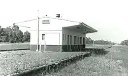
Construction of the South Western Railway reached the district in 1892. Some time later a stop bearing the name Beenup was established in the vicinity of the present day township. In 1957 a station was established on the line between Abernethy Road and Mead Street.[15] After a long period of disuse, this station was demolished around 1990. The current Byford station is located just south of this. It is served by Transwa's twice daily Australind service from Perth to Bunbury.[16]
In the 1920s the estate of a local land-owner, Samuel Bateman, was subdivided into smaller farms for the Group Settlement Scheme.[17]
Employment provided by the State Brickworks, the Cardup Brickworks, and the munition works (i.e. the Royal Australian Navy Armament Depot) that were established between Nettleton Road and the Cardup Brook in 1942[18] were significant factors contributing to growth of the township of Byford. It was also a service town for a number of mill communities in the hills to the east and south-east, as well as a thriving rural community.
Late 20th and early 21st century
In 1977, the local government responsibilities for Byford were transferred from the Shire of Armadale-Kelmscott (now the City of Armadale) to the Shire of Serpentine-Jarrahdale.[19] Recently, Byford has become an extension of the Perth metropolitan area, connected to the Kwinana Freeway by Thomas Road, and has experienced a substantial rise in population.
Historically, Byford's rural land supported sheep, beef and dairy cattle, orchards, and a vineyard (Sunrays, owned by the Vlasich family),[20] but in recent decades there has been an increase in hobby farms geared to equine pursuits, and more recently housing estates with generous lot sizes.
A Free Reformed Church was opened on the corner of Soldiers Road and Mead Street in 1987, and a private school was later built alongside this church.
The new subdivision "Byford on the Scarp" was constructed on the long-disused Navy Armament Depot. The depot was closed in 1981 and its functions relocated to Garden Island. After standing empty and neglected for many years, the storage bunkers and other depot buildings were progressively demolished, this work being complete in 2000. Traces of the rail infrastructure that once served the depot and brickworks still are visible today.
In the early 2010s, "The Glades" was developed in the town's west and it became the first real estate development in the state to receive certification in the three categories of the UDIA EnviroDevelopment program. The development went on to win three awards, including two national awards.[21]

Cultural and natural sites
Established in 1982, Cohunu Koala Park is a wildlife sanctuary.[22] The sanctuary houses dingoes, koalas, kangeroos, wallabies, emus, deers and owls among others.[23] Byford contains numerous other parks and public ovals.[24]
Cultural sites include a war memorial to those who fought in World War I and II, and the Korean, Malaysian, Borneo and Vietnam Wars.[25] A larger war memorial dedicated to the ANZACs opened on 18 April 2015.[26] The memorial commemorates 321 soldiers from Byford who died.[27]
Education
As a rapidly developing suburb, Byford has seen an increase in education institutions.[28]
To the east of the South Western Highway are located two institutions. The Byford Community Kindergarten was built in 1978. In March 2017, Department of Fire and Emergency Services deemed it high risk to bushfire due to surrounding bushland. It reopened in 2019.[29][30] Founded in 1921, Byford Primary school (BPS) is the oldest school in the area.[31] In 2015, it became an independent school. Due to the Kindergarten's closure, an early childhood building was added in 2018.[32] In 2023, former student Damien Oliver returned to BPS before his retirement.[33] The school also teaches Italian.
Opened in 1993, Marri Grove Primary school is a government school that also has Indonesian as a subject.[34] Byford John Calvin school was opened on 29 January 1999 next to the Free Reformed Church and is private.[35] On Byford's west, the government school of West Byford Primary opened in February 2013.[28] Salvado Catholic College, a Catholic school for students from Kindergarten to Year 12 was opened in 2016. The college is named after its patron Dom Rosendo Salvado, who inspired the school's motto “Peace, Justice, Compassion.[36] It also teaches Italian.[37] In 2017, Woodland Grove Primary School and is a government school.[38] The last school to open was Beenyup Primary School in 2020 as a government school.
Byford and the Shire of Serpentine-Jarrahdale's only secondary-only school is the government Byford Secondary College, which opened in 2014.
Transportation
Road transport
Byford is the location of the intersection between South Western Highway and Thomas Road, acting also as the eastern terminus of Thomas Road. As part of the Metronet Byford Rail Extension Project, the section of Thomas Road before the intersection was raised in order to remove the train crossing previously there. The new Thomas Road bridge opened on 15 November 2022.[39] Below are the two major roads that go through Byford and their direction:
 South Western Highway (State Route 20) – south to Pinjarra and Bunbury.
 Thomas Road (State Route 21) - west to Kwinana; eastern terminus in Byford.
Other important roads include Abernethy road, which connects Oakford to the South Western Highway; Nettleton road, which connects Byford to Jarrahdale through Karrakup; and Soldiers road, which connects to Mundijong.
Public transport
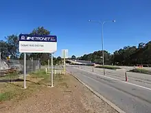
As part of the Metronet Byford Rail Extension Project, the Armadale line will be extended 8 km south to a new station in Byford. As part of the extension, the Armadale Line is set to be shut down 20 November 2023.[40] The new station will be situated opposite George street and will consist of three platforms serving passengers of the Australind and Armadale lines.[41] Rita Saffioti, the state's Minister of Transport, and Hugh Jones, local Member of the Legislative Assembly, spoke of the station by saying it would boost Byford's future development and growth.[42]
In terms of busses, there are five bus stops along the South West highway in the town's main center. There also operates busses which take passengers to the main center.[43]
References
- Australian Bureau of Statistics (28 June 2022). "Byford (Suburb and Locality)". Australian Census 2021 QuickStats. Retrieved 28 June 2022.
- "History of country town names – B". Western Australian Land Information Authority. Archived from the original on 14 March 2022. Retrieved 8 June 2007.
- Coy, N.J.; The Serpentine: a history of the Shire of Serpentine-Jarrahdale, Shire of Serpentine-Jarrahdale, 1984; pp.17,181
- "Our History » Shire of Serpentine Jarrahdale". www.sjshire.wa.gov.au. Retrieved 4 June 2023.
- A journal entry by the Reverend J.R.Wollaston dated 1853 reports favourably on the quality of Wongong Farm, noting that land of this quality "prevails for many miles along the range, and I am surprised it has not been more sought out and located. Want of roads and bridges is a great drawback." Ref: Wollaston's Albany journals (1848-1856): being volume 2 of the journals and diaries (1841-1856) of Revd. John Ramsden Wollaston, M.A., Archdeacon of Western Australia, 1849-1856; collected by Rev. Canon A. Burton; edited with notes by Canon Percy U. Henn; introduction by Malcolm J.L. Uren, Paterson Brokensha Pty, Perth, 1954.
- SROWA Cons 3869, Cockburn Sound 139. On this plan, H.Mead and J.F.Lazenby are shown to own all but one of approximately 20 land allocations on the Beenyup and Cardoup brooks. Apart from these title holders, J.W.Davey is shown as owning 160 acres on the north side of Cardoup Brook and S.Jones as owning 50 acres immediately north of this, bounded to the north by Beenyup Brook.
- Carter, J & B; Settlement to City: A history of the Armadale district and its people; City of Armadale, 2011, pp. 341-344.
- Taggart, N; Rockingham Looks Back: A History of the Rockingham District 1829-1982; Rockingham District Historical Society (Inc.), 1984, p. 49.
- Moore, B.; From the ground up: Bristile, Whittakers and Metro Brick in Western Australian history, University of Western Australia Press, 1987; pp.42-47
- Coy, 1984; pp.181, 183
- The West Australian, 28 March 2012
- Popham, D.; First stage south: a history of the Armadale-Kelmscott district, Western Australia; p.109.
- State Records Office plan: Cons 5698 Item 0306
- Popham, 1980; p. 109. An aerial photograph of Byford taken 10 June 1949 shows the 1906 townsite undeveloped (and still cloaked in native vegetation) except the recreation reserve which had a race track
- Coy, 1984; p.190
- Australind Timetable Transwa
- "The Brook at Byford" (PDF). Shire of Serpentine-Jarrahdale. Retrieved 25 March 2021.
- The West Australian, 4 October 1945; p.9; see also webpage: http://users.tpg.com.au/borclaud/ranad/about_byford.html
- Carter, 2011, pp. 341-344.
- Government Gazette of Western Australia, 12 January 1962, p 132: Notice indicating the dissolution of the family business as at 30 June 1960.
- "About the Estate | The Glades at Byford". byford.com.au. Retrieved 17 September 2023.
- "Cohunu Koala Perk – Byford WA". Retrieved 18 September 2023.
- "Cohunu Koala Park - Attraction - Tourism Western Australia". Western Australia. Retrieved 18 September 2023.
- "Parks and Facilities » Shire of Serpentine Jarrahdale". www.sjshire.wa.gov.au. Retrieved 18 September 2023.
- "Byford War Memorial | Places of Pride". placesofpride.awm.gov.au. 5 April 2019. Retrieved 18 September 2023.
- "Anzac Memorial Park | Places of Pride". placesofpride.awm.gov.au. 18 April 2015. Retrieved 18 September 2023.
- "ANZAC Memorial Park | Monument Australia". monumentaustralia.org.au. Retrieved 18 September 2023.
- "School Overview West Byford Primary School". www.det.wa.edu.au. Retrieved 18 September 2023.
- Vellinga, Chloe (14 March 2019). "Byford kindergarten no longer a fire risk". Your Local Examiner. Retrieved 18 September 2023.
- "Shire Serpentine-Jarrahdale - New-look Byford Community Kindergarten re-opens 12 March 2019 2019". www.councilnews.com.au. Retrieved 18 September 2023.
- Hunt, Annalise (18 February 2021). "School's search for oldest student". Your Local Examiner. Retrieved 12 September 2023.
- Schoolzine. "Byford Primary School Website". Byford Primary School Website. Retrieved 18 September 2023.
- "Ollie's emotional stop at primary school". thewest.com.au. 3 August 2023. Retrieved 18 September 2023.
- "School Overview Marri Grove Primary School". www.det.wa.edu.au. Retrieved 18 September 2023.
- "Byford John Calvin School". 18 September 2023.
- "About Us". Salvado Catholic College. Retrieved 18 September 2023.
- "Salvado Catholic College BYFORD". CEWA. Retrieved 18 September 2023.
- "Woodland Grove Primary School – AN INDEPENDENT PUBLIC SCHOOL | 15 McMillan Road, Byford WA | T: 08 9526 4000". Retrieved 18 September 2023.
- "New Thomas Road Bridge opens". METRONET. Retrieved 17 September 2023.
- "Byford Rail Extension". www.metronet.wa.gov.au. Retrieved 17 September 2023.
- Hastie, Hamish (24 August 2023). "Designs for long-awaited Byford train station revealed". WAtoday. Retrieved 17 September 2023.
- "First look at the new METRONET Byford Station | Western Australian Government". www.wa.gov.au. Retrieved 17 September 2023.
- "Transport". Cedarwoods. Retrieved 18 September 2023.
External links
- ByfordWA
- Heritage Country Choir
- Jarrahdale Heritage Society
- Byford Bushrangers tee-ball/baseball/softball club
![]() Media related to Byford, Western Australia at Wikimedia Commons
Media related to Byford, Western Australia at Wikimedia Commons