Oakford, Western Australia
Oakford is an outer suburb of Perth, Western Australia, within the Shire of Serpentine-Jarrahdale. The suburb was named in 1982, taking its name from a townsite briefly declared in the area in 1926.[2]
| Oakford Perth, Western Australia | |||||||||||||||
|---|---|---|---|---|---|---|---|---|---|---|---|---|---|---|---|
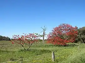 Trees and fields in predominantly rural Oakford | |||||||||||||||
| Coordinates | 32.212°S 115.931°E | ||||||||||||||
| Population | 2,803 (SAL 2021)[1] | ||||||||||||||
| Postcode(s) | 6121 | ||||||||||||||
| Area | 46.9 km2 (18.1 sq mi) | ||||||||||||||
| Location | 36 km (22 mi) S of Perth | ||||||||||||||
| LGA(s) | Shire of Serpentine-Jarrahdale | ||||||||||||||
| State electorate(s) | Darling Range | ||||||||||||||
| Federal division(s) | Canning | ||||||||||||||
| |||||||||||||||
Infrastructure and economy
Agriculture
Borrello Cheese, established over 40 years ago, operates in Oakford and produces cheeses in Italian styles which are exported to stores and restaurants around Perth.[3]
Education
Oakford doesn't have any schools, but the cloest schools are West Byford Primary School, Woodland Primary School, Beenyup Primary School, Carey Baptist College Forrestdale, Hammond Park Secondary College
Fire
In Oakford operates the Oakford Volunteer Bush Fire Brigade. There are also plans on the construction of an Oakford Volunteer Bush Fire Brigade Station.[4]
Transportation
Within Oakford are Thomas, Nicholson roads and Tonkin highway; with both the south ends of Nicholson road and Tonkin highway ending at intersections with Thomas road in Oakford.
Since 2023, sections of Kargotich road have been closed due to construction of new roundabouts on Thomas road intersection with Kargotich and Nicholson roads. Road works are expected to mid-2024.[5] This is in order to improve traffic flow along the Kwinana and South Western highways.[6] Tonkin Highway is also being extended through Oakford to Jarrahdale.[7]
Below are the three major roads and their directions:
 Tonkin Highway (State Route 4) - north to Muchea and Perth Airport; south terminus at Thomas Road in Oakford.
 Thomas Road (State Route 21) - west to Kwinana; east to Byford.
 Nicholson Road (State Route 31) - north to Gosnells; south terminus at Thomas Road in Oakford.
References
- Australian Bureau of Statistics (28 June 2022). "Oakford (Suburb and Locality)". Australian Census 2021 QuickStats. Retrieved 28 June 2022.
- "History of metropolitan suburb names – O". Western Australian Land Information Authority. Archived from the original on 16 March 2022. Retrieved 15 June 2007.
- "Borrello Cheese". wacheese.com.au. Retrieved 19 September 2023.
- "News Story - Update: Oakford Volunteer Bush Fire Brigade Station » Shire of Serpentine Jarrahdale". www.sjshire.wa.gov.au. Retrieved 19 September 2023.
- "Thomas Road Safety Improvements". Mainroads Western Australia. 6 July 2023. Retrieved 19 September 2023.
- "Thomas Road Improvements Kargotich Road and Nicholson Road Roundabout" (PDF). Mainroads Western Australia. Retrieved 19 September 2023.
- "Tonkin Highway Extension | Main Roads Western Australia". www.mainroads.wa.gov.au. 12 September 2023. Retrieved 19 September 2023.