Canal Lewisville, Ohio
Canal Lewisville is an unincorporated community and census-designated place (CDP) in Coshocton County, Ohio, in the United States. As of the 2020 census it had a population of 417.
Canal Lewisville, Ohio | |
|---|---|
 Canal Lewisville | |
| Coordinates: 40°17′57″N 81°50′10″W | |
| Country | United States |
| State | Ohio |
| County | Coshocton |
| Townships | Keene, Tuscarawas |
| Area | |
| • Total | 0.42 sq mi (1.08 km2) |
| • Land | 0.42 sq mi (1.08 km2) |
| • Water | 0.00 sq mi (0.00 km2) |
| Elevation | 772 ft (235 m) |
| Population (2020) | |
| • Total | 417 |
| • Density | 997.61/sq mi (385.39/km2) |
| Time zone | UTC-5 (Eastern (EST)) |
| • Summer (DST) | UTC-4 (EDT) |
| Area code | 740 |
| FIPS code | 39-11318[3] |
| GNIS feature ID | 1056763[2] |
History
Canal Lewisville had its start by the building of the Ohio Canal through that territory.[4] It was laid out as a town in 1832 by T. Butler Lewis and others, and named for the former.[5] A post office called Canal Lewisville was established in 1845, and remained in operation until 1915.[6]
Geography
Canal Lewisville is located in east-central Coshocton County on the border of Keene and Tuscarawas townships. It is on the north bank of the Tuscarawas River, 3.3 miles (5.3 km) northeast (upstream) of its confluence with the Walhonding River at Coshocton to form the Muskingum River, a tributary of the Ohio.
According to the United States Census Bureau, the CDP has an area of 0.42 square miles (1.1 km2), all land.[7]
References
- "ArcGIS REST Services Directory". United States Census Bureau. Retrieved September 20, 2022.
- "US Board on Geographic Names". United States Geological Survey. 2007-10-25. Retrieved 2008-01-31.
- "U.S. Census website". United States Census Bureau. Retrieved 2008-01-31.
- Graham, Albert Adams (1881). History of Coshocton County, Ohio: Its Past and Present, 1740-1881. A. A. Graham. pp. 606.
- Hunt, William Ellis (1876). Historical Collections of Coshocton County, Ohio. R. Clarke & Company. pp. 5.
- "Coshocton County". Jim Forte Postal History. Archived from the original on 8 December 2015. Retrieved 7 December 2015.
- "Geographic Identifiers: 2010 Demographic Profile Data (G001): Canal Lewisville CDP, Ohio". U.S. Census Bureau, American Factfinder. Archived from the original on February 3, 2015. Retrieved February 2, 2015.
- "Census of Population and Housing". Census.gov. Retrieved June 4, 2016.
Municipalities and communities of Coshocton County, Ohio, United States | ||
|---|---|---|
| City | 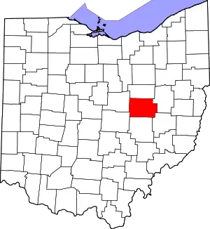 Map of Ohio highlighting Coshocton County | |
| Villages | ||
| Townships | ||
| CDPs | ||
| Unincorporated communities |
| |
| Ghost towns | ||
| Footnotes | ‡This populated place also has portions in an adjacent county or counties | |