Caney Ridge, Oklahoma
Caney Ridge is an unincorporated community and census-designated place (CDP) in Cherokee County, Oklahoma, United States, within the Cherokee Nation. It was first listed as a CDP prior to the 2020 census.[2]
Caney Ridge, Oklahoma | |
|---|---|
 Caney Ridge  Caney Ridge | |
| Coordinates: 35°45′52″N 94°52′51″W | |
| Country | United States |
| State | Oklahoma |
| County | Cherokee |
| Area | |
| • Total | 0.44 sq mi (1.14 km2) |
| • Land | 0.28 sq mi (0.73 km2) |
| • Water | 0.16 sq mi (0.41 km2) |
| Elevation | 712 ft (217 m) |
| Population (2020) | |
| • Total | 120 |
| • Density | 425.53/sq mi (164.40/km2) |
| Time zone | UTC-6 (Central (CST)) |
| • Summer (DST) | UTC-5 (CDT) |
| ZIP Code | 74471 (Welling) |
| Area code(s) | 918/539 |
| FIPS code | 40-11575 |
| GNIS feature ID | 2812846[2] |
The CDP is in southeastern Cherokee County, on a ridge between two arms of Tenkiller Ferry Lake: Caney Creek to the north and Dry Creek to the south. The CDP is bordered to the north by Tenkiller, to the east by Barber, and to the south by Dry Creek. The western tip of the CDP touches the Illinois River in Tenkiller Ferry Lake.
Oklahoma State Highway 100 passes through Caney Ridge, leading east 17 miles (27 km) to Stilwell and southwest 1 mile (1.6 km) to its end at State Highway 82, which leads northwest 13 miles (21 km) to Tahlequah, the Cherokee county seat.
References
- "ArcGIS REST Services Directory". United States Census Bureau. Retrieved September 20, 2022.
- U.S. Geological Survey Geographic Names Information System: Caney Ridge, Oklahoma
- "Census of Population and Housing". Census.gov. Retrieved June 4, 2016.
Municipalities and communities of Cherokee County, Oklahoma, United States | ||
|---|---|---|
| City | 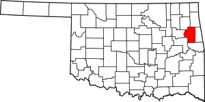 Cherokee County map | |
| Towns | ||
| CDPs | ||
| Other community | ||
| Indian reservation | ||
| Footnotes | ‡This populated place also has portions in an adjacent county or counties | |