Catoctin Creek (Maryland)
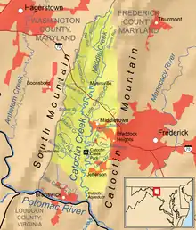
Catoctin Creek is a 27.9-mile-long (44.9 km)[1] tributary of the Potomac River in Frederick County, Maryland, USA. Its source is formed north of Myersville. In Myersville, it merges with the Little Catoctin Creek at Doub's Meadow Park.[2] From there, it flows directly south through Middletown, and Frederick for the entire length of the stream collecting several smaller tributaries. It makes a crossing with the Chesapeake and Ohio Canal at the Catoctin Aqueduct, one of just 11 of these structures to survive.[2] Catoctin Creek enters the Potomac River east of Brunswick.

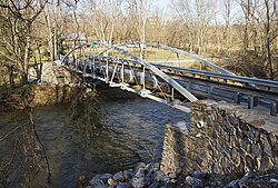
Catoctin Aqueduct
| Catoctin Creek | |
|---|---|
 | |
 | |
| Etymology | Catoctin Mountain |
| Location | |
| Country | United States of America |
| State | Maryland |
| Region | Frederick County |
| Physical characteristics | |
| Source | Ellerton, Maryland |
| • location | 39.55113°N 77.55205°W |
| Mouth | Potomac River |
• location | Lander, Maryland |
• coordinates | 39.2756576°N 77.5510994°W |
• elevation | 217 ft (66 m) |
| Length | 27.9 mi (44.9 km) |
| Basin size | 120.53 sq mi (312.2 km2) |
| Discharge | |
| • location | Lander, Maryland |
| • average | 145.01 cfs |
| Basin features | |
| River system | Potomac River |
| Cities | Myersville, Middletown, Frederick, Jefferson |
| Tributaries | |
| • left | Little Catoctin Creek, Lewis Mill Branch |
| • right | Little Catoctin Creek, Broad Run |
See also
References
- U.S. Geological Survey. National Hydrography Dataset high-resolution flowline data. The National Map Archived 2012-03-29 at the Wayback Machine, accessed August 15, 2011
- "Tributary Tuesday: Catoctin Creek (Frederick County, Md.)". Chesapeake Bay. 2012-01-24. Retrieved 2023-09-07.
This article is issued from Wikipedia. The text is licensed under Creative Commons - Attribution - Sharealike. Additional terms may apply for the media files.