Chak Dina
Chak Dina[2] (/tʃək dinə/; Urdu: چک دینا; Colloquial: Dina Chak), is a village in Kharian Tehsil of Gujrat District, Punjab, Pakistan. It is situated at about five km westwards from the town of Lalamusa. It is located at 32°42'0N 73°53'0E with an altitude of 233 metres (767 feet).[3]
Chak Dina
چک دینا Chak Deenah چک دینہ (on Google Maps) | |
|---|---|
Village | |
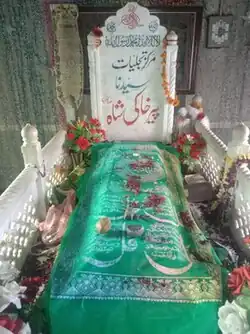 The tomb of Pir Khaki Shah at Chak Dina. Photo by Asjad Iqbal (2023). | |
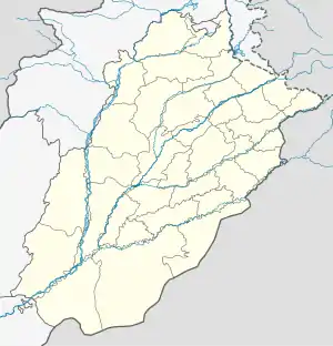 Chak Dina Location in Punjab, Pakistan | |
| Coordinates: 32°42′0″N 73°53′0″E | |
| Administration type | District administration |
| District | Gujrat |
| Tehsil | Kharian |
| Police Circle | Headquarters Circle |
| Thana | Saddar Lalamusa[1] |
| Kanungoi Circle | Lalamusa |
| Patwar Circle | Jataria Kalan |
| Government | |
| • Government type | Local government |
| • Union Council | Kotla Qasim Khan |
| • Justice system | District and Session Courts |
| Elevation | 233 m (767 ft) |
| Population | |
| • Total | 1,792 (According to 2,023 Census) |
| Demonym | Dinay Chakia |
| Time zone | UTC+5 (PST) |
| Zip code | 50200 |
| Area code | 0537 |
Chak Dina which previously fell in the Gunja Union Council, is now part of Kotla Qasim Khan Union Council. Other villages in this Union Council are Saida Baraham, Sukhchaina, Chakori Khurd, Thurgala and Jalaldin.
Revenue circles
The village falls under the revenue limits of Kanungoi Circle Lalamusa and Patwar Circle Jataria Kalan. A Kanungoi Circle is headed by a Kanungo (also Qanungo[4][5]) and a Patwar Circle is headed by a Patwari.
Etymology
The name Chak Dina is combination of words 'Chak' meaning village and 'Dina' meaning of Allahdin. The first inhabitant of the village Chaudhry Allahdin was nicknamed Dina hence Chak Dina became the name of the village. There are other villages in the close vicinity which have names of the same pattern like Chak Ikhlas and Chak Rajjadi.
History
The village was founded in the second half of the 18th century CE by Chaudhry Allahdin, a Muslim descendant of Hindu Shahi ruler Jayapala at the site of Shahpur, a city ruined by revolution of the time.
Ships named after Chak Dina
British India Steam Navigation Company (BI) (registered in 1856 as the Calcutta & Burmah Steam Navigation Company and got new name in 1862) borrowed the name Chakdina from this village to name two of its ships.
Chakdina (1)
Chakdina (1) built in 1914 was bombed and sunk in Mediterranean in 1941.[6]
Chakdina (2)
Chakdina (2) built in 1951 was transferred to Peninsular and Oriental (P&O) Steam Navigation Company in 1973. In 1975, it was renamed Strathlairg and scrapped in Taiwan in 1977.[7]
Population
Most of the present population of the village, traces its descent from Chaudhry Allahdin who belonged to the Kunduana offshoot of Khatana sub-caste of the Gujars. However, the village also has other sub-castes of Gujars like Porr, Machiwal etc. The village also has Syed and Kashmiri families. Population of the village is on the increase since Pakistan came into being. The following is the statistics:
| Census Year | Male | Female | Total |
|---|---|---|---|
| 1951[8] | Not mentioned | Not mentioned | 720 |
| 1961[9] | 410 | 348 | 758 |
| 1972[10] | 543 | 474 | 1,017 |
| 1981[11] | 546 | 593 | 1,139 |
| 1998[12] | 688 | 674 | 1,362 |
| 2017 | 782 | 846 | 1,628 |
| 2023 | 1,792 | ||
Land
The following is the statistics of the village land according to successive population censuses conducted since the creation of Pakistan:
| Census Year | 1951 | 1961 | 1972 | 1981 |
|---|---|---|---|---|
| Area in Acres | 1,152 | 1,152 | 1,152 | |
Immigration
In 1966, after the Mangla Dam was built on the Jhelum River, some effected people from Mirpur (Azad Jammu and Kashmir) whose property had come under waters of the dam migrated to the village and inhabited a new locality namely Chak Fazal Shah within the revenue limits of Chak Dina. Besides purchasing land for inhabiting their locality, they also purchased some agricultural land from the people of Chak Dina. In return for such land, the local land holders were helped to immigrate their sons to England for job. As such five boys of the village immigrated to England who later settled there.
Some overseas workers belonging to this village have also settled in other European countries such as Norway, Italy, France, Spain and Portugal and in North America.
Schools
The village has elementary (I-VIII) school for boys and primary (I-V) school for girls.[13][14]
Tombs
There are tombs of saints Sain Khaki Shah, Hafiz Jan Muhammad and Sain Bahawal Sher in the village. Grooms before proceeding on wedding procession, on their wedding day, offer Salam at Sain Khaki Shah Darbar. Similarly, those proceeding on foreign trips also pay a visit to the Darbar. Every visitor to the Sain Khaki Shah Darbar also offers Salam at the tomb of Sain Jan Muhammad. People of the village make an offering of a Mohrik (موہرک) (buffalo/cow collar rope) at the tomb of Sain Bahawal Sher after their buffalo or cow gets in a family way.
Bazaar Dinay Chakian
One of the famous bazaars in the town of Lalamusa is named after Chak Dina and is called Bazaar Dinay Chakian. Dinay Chakian means, in Punjabi, the people from Dina Chak. This bazaar was inhabited by Bagh Sha, a Hindu who migrated from Chak Dina to Lalamusa in 1929. The first building in the bazaar was Haveli Bagh Sha. This was also the first building of the city of Lalamusa built according to a floor plan prepared by an achitect. Some parts of this building are still present in original form.
Other places with similar names
There are a few other places with the similar names in the sub-continent. A village named Chak Dina is located in Gujrat Tehsil of the same district. Another village named Chak Dina is situated in Jammu District of the Indian-administered Kashmir. This village falls near the Working Boundary -- the border between Sialkot District of Pakistan and the Jammu District of the Indian-administered Kashmir. Yet another village with slightly different name called Chak Dina Khan is inhabited in Azamgarh District of Uttar Pradesh state, India.
References
- https://www.punjabpolice.gov.pk/gujrat_directory
- https://books.google.com/books?id=gkW50zMncW4C&dq=chak+dina&pg=PA150 Page:150
- "District Website". gujrat.dc.lhc.gov.pk. Retrieved 26 May 2023.
Gujrat (URDU), is a district of Punjab Province in Pakistan. Gujrat is an ancient district located in between two famous rivers, the Jhelum and Chenab. It is bounded on the northeast by Mirpur, on the northwest by the River Jhelum which separates it from Jhelum District, on the east and southeast by the Chenab River, separating it from the districts of Gujranwala and Sialkot, and on the West by Mandi Bahauddin. District Gujrat is spread over an area of 3,192 square kilometres, and it includes historic villages and towns such as Jalalpur Jattan, Chakdina, Karnana, Kunjah and Lalamusa."
- https://en.wiktionary.org/wiki/Qanungo
- https://en.banglapedia.org/index.php/Qanungo
- "Assorted Class". Archived from the original on 6 December 2010. Retrieved 10 June 2010.
- "The C Class". Archived from the original on 6 December 2010. Retrieved 31 July 2010.
- Census of Pakistan, 1951, Village List, Punjab, Gujrat District, Office of the Provincial Superintendent Census, Punjab and Bahawalpur, Lahore, June 1952, Page: 45
- http://111.68.102.42:8080/xmlui/handle/123456789/16292 Population Census of Pakistan, 1961: Gujrat - Page 70
- http://111.68.102.42:8080/xmlui/handle/123456789/15391 Population Census of Pakistan, 1972: Gujrat - Page 155
- http://111.68.102.42:8080/xmlui/handle/123456789/14751 1981 District Census Report of Gujrat - Page 121
- http://111.68.102.42:8080/xmlui/handle/123456789/14618 1998 District Census Report of Gujrat - Page 276
- "Govt Boys Elementary School, Chak Dina". Gujratinfo.com. Retrieved 27 January 2022.
- "GGCMS Chak Dina Gujrat – School Info & Teachers Profiles". UrduPoint.com. Retrieved 27 January 2022.