Sialkot District
Sialkot District (Punjabi and Urdu: ضلع سیالکوٹ), is one of the districts of the Punjab province of Pakistan. It is located in the Majha region of Panjab, otherwise the northeast of the province. The city of Sialkot is the capital of the district. The Sialkot Cantonment was established in 1852.
Sialkot District
ضلع سیالکوٹ | |
|---|---|
 .jpg.webp) Top: Sialkot Clock Tower Bottom: Village of Kotli Noonan | |
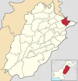 Map of Sialkot District highlighted | |
| Country | |
| Province | |
| Division | Gujranwala |
| Capital | Sialkot |
| Government | |
| • Type | District Administration |
| • Deputy Commissioner | Zeeshan Javed |
| • District Police Officer | Abdul Ghaffar Qaisrani |
| • CEO Education | Mian Riaz Ahmed |
| Area | |
| • Total | 3,016 km2 (1,164 sq mi) |
| Population | |
| • Total | 3,894,938 |
| • Density | 1,300/km2 (3,300/sq mi) |
| Time zone | UTC+5 (PST) |
| Number of Tehsils | 4 |
| Website | sialkot |
Administration
The district is administratively divided into the following four tehsils (subdivisions), which contain a total of 122 Union Councils:[2][3][4]
| Tehsil | No. of Unions |
|---|---|
| Daska | 42 |
| Pasrur | 28 |
| Sambrial | 30 |
| Sialkot | 52 |
| Total | 152 |
History
Sialkot District was an agricultural region with forests during the Indus Valley Civilization. The Vedic period is characterized by Indo-Aryan culture that flourished in the Punjab region. The Kambojas, Daradas, Kaikayas, Madras, Pauravas, Yaudheyas, Malavas and Kurus invaded, settled and ruled the ancient Punjab region. After overrunning the Achaemenid Empire in 331 BCE, Alexander marched into the present-day Punjab region with an army of 50,000. The Sialkot was ruled by Maurya Empire, the Indo-Greek kingdom, Kushan Empire, Gupta Empire, White Huns, Kushano-Hephthalites, the Arabs and Hindu Shahi kingdoms.
In 997 CE, Sultan Mahmud Ghaznavi took over the Ghaznavid dynasty empire established by his father, Sultan Sebuktegin, In 1005 he conquered the Shahis in Kabul in 1005 CE and followed by the conquests of the Punjab region. The Delhi Sultanate and later Mughal Empire ruled the region.
The legendary history of the District is connected with Raja Salivahan, the reputed founder of the town of Sialkot, and his famous son Rasalu. Pasrur is also an ancient place. At an early date the District fell to the Rajas of Jammu, and under the Mughals formed the Rechna Doab sarkar of the Subah of Lahore. Under Shah Jahan the sarkar was entrusted to Ali Mardan Khan, the famous engineer, who dug a canal through it to bring water from the Chenab river to the imperial gardens in Lahore.
On the decline of the Mughal Empire Ranjit Singh Deo, a Rajput hill chief, extended his sway over the lowlands, owning a nominal allegiance to Delhi. In 1748 he transferred his allegiance to Ahmad Shah Durrani, who added Zafarwal and two other parganas to his fief. Before his death in 1773 Ranjit Deo had secured possession of the whole District, except the Sialkot town and its dependencies, which were held by a Pashtun family.[5]
During the Indian Rebellion of 1857 the station was denuded of British troops; and the Native regiments which were left behind the rose, and, after sacking the jail, treasury, and courthouse, and massacring several of the European inhabitants, marched off towards Delhi, only to be destroyed by Nicholson at Trimmu Ghat. The rest of the Europeans took refuge in the fort, and on the morning after the departure of the rebels order was restored. The only events of interest in the subsequent history of the District are the plague riots that occurred at the villages of Shahzada and Sankhatra in 1901.[5]
Numerous mounds are scattered about the District, which marks the sites of ancient villages and towns. None of them, except that on which the Sialkot fort stood, has been excavated, but silver and copper utensils and coins have been dug up from time to time by villagers. Most of the coins are those of Indo-Bactrian kings. The excavations in Sialkot revealed the existence of some old baths, with hot-water pipes of solid masonry. The fort itself, of which very little now remains, is not more than 1,000 years old and is said to have been rebuilt by Shahab-ud-din Ghori at the end of the twelfth century.[5]
In 1859, Gurdaspur, Amritsar and Sialkot were placed in the new division of Sialkot. But in 1884, Gurdaspur along with Amritsar again became a part of the Lahore Division.
According to the 1901 census, the district had a population of 1,083,909 and contained 7 towns and 2,348 villages. The population at the previous three enumerations was: 1,004,695 (1868), 1,012,148 (1881) and 1,119,847 (1891). The population decreased between 1891 and 1901 by 3.2,[5] the decrease being greatest in the Raya tahsil and least in the Daska tahsil. The Chenab Colony was responsible for this fall in population, with no less than 103,000 persons having left to take land in the newly irrigated tracts.[6]
The district was subdivided into five tehsils, namely: Sialkot, Pasrur, Zafarwal, Raya and Daska, the headquarters of each being at the place from which it is named. The chief towns of the district were Sialkot, Daska, Jamki, Pasrur, Kila Sobha Singh, Zafarwal and Narowal.[6]
| Tehsil | Area (sq mi) | Towns | Villages | Population (1901) | Population per sq mi | Population variation 1891–1901 | Number of literate people |
|---|---|---|---|---|---|---|---|
| Sialkot | 428 | 1 | 637 | 312,668 | 730.5 | +3.2 | 12,101 |
| Pasrur | 394 | 2 | 443 | 193,746 | 491.7 | −5.0 | 5,601 |
| Sambrial | 485 | 1 | 456 | 192,440 | 396.8 | +10.4 | 5,586 |
| Daska | 360 | 2 | 332 | 206,148 | 572.6 | −0.6 | 4,103 |
| Total | 1,991 | 7 | 2,348 | 1,083,909 | 544.4 | −3.2 | 31,341 |
In 1930, the tehsils of Raya, Daska and Pasrur were split up and parts of these were amalgamated into Gujranwala District. In 1991, the tehsils of Narowal and Shakar Garh (which was tehsil Shankar Garh of Gurdaspur district before the independence of Pakistan in 1947) were split up and formed into the new Narowal District.
Geography
Sialkot District lies southeast of Gujrat District, southwest of Jammu district (in Jammu and Kashmir, India), while Narowal District is to the southeast and Gujranwala District is situated to the west.
Sialkot district is spread over an area of 3,016 square kilometers.

Sialkot is hot and humid during the summer and cold during the winter. June and July are the hottest months. The maximum temperature during winter may drop to −2 °C (28 °F). The land is generally plain and fertile. The average annual rainfall is about 1000 mm. Over 25.82% of the population of the district is urban.[7]
Demographics
At the time of the 2017 census, the district had a population of 3,894,938, of which 1,921,289 were males and 1,973,150 were females. The rural population is 2,750,403 while the urban population is 1,144,535. Islam is the predominant religion with 96.04% of the population while Christians are 3.50% of the population.[1]
At the time of the 2017 census, 94.92% of the population spoke Punjabi, 2.47% Urdu and 1.26% Pashto as their first language.[1]
There is a small Hindu community in Sialkot. The Shivala Teja Singh temple is a historic Hindu temple in Sialkot.[8][9]
| Religion | Population (1941)[10]: 42 | Percentage (1941) |
|---|---|---|
| Islam |
740,218 | 62.18% |
| Hinduism |
231,319 | 19.43% |
| Sikhism |
139,409 | 11.71% |
| Christianity |
73,846 | 6.2% |
| Others [lower-alpha 3] | 5,705 | 0.48% |
| Total Population | 1,190,497 | 100% |
Notable people
Historical figures
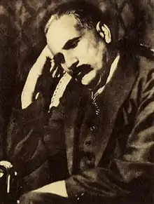
- Allama Iqbal, poet and philosopher
- Sir Muhammad Zafarullah Khan, Pakistan's first Foreign Minister and President of the UN-General Assembly
- Faiz Ahmad Faiz,[note 1] poet and scholar
- Syed Faiz-ul Hassan Shah, great orator, poet and pir, has been president of Jamiat Ulema-e-Pakistan
- Zafar Ali Khan writer, poet, and journalist who played an important role in the Pakistan Movement
- Sir Fazl-i-Hussain was one of the most Influential politicians in the United Punjab
- Ubaidullah Sindhi pre-partition Muslim Scholar and leader
- Gulzarilal Nanda, Indian politician and twice Prime Minister of India
- Umera Ahmad famous Urdu fiction writer of modern era
- Chaudhry Naseer Ahmad Malhi[note 1] a leading member of the Muslim League
- Abdul Hakim Sialkoti famous Muslim intellectual of 16th century
- Chaudhry Sir Shahab-ud-Din Virk, lawyer and politician in pre-partition.[11][12]
Military
- Air Marshal Zafar Chaudhry was the first Chief of Air Staff
- General Khalid Shameem Wynne the 14th Chairman of the Joint Chiefs of Staff Committee
Journalists and poets
- Kuldip Nayar, Indian journalist
- Amjad Islam Amjad, Urdu writer, lyricist, and poet
- Rajinder Singh Bedi, writer
- Khalid Hasan, who was born in Srinagar but studied and lived in Sialkot.
- Hamid Mir, a Pakistani journalist who was born in Sialkot
- Abdal Bela, Urdu writer
- Taufiq Rafat, a British-Pakistani poet
Politicians
- mian masood ahmed
Former pakistan politician former MNA ,former member of kashmir committee
- Chaudhry Amir Hussain, former Speaker of Pakistan National Assembly, former acting President of Pakistan and Federal Minister of Pakistan 3 times
- Khawaja Muhammad Safdar, Pakistani politician and former acting President of Pakistan
- Syed Iftikhar Ul Hassan, Politician from Allo Mahar, re-elected several time as a Member of the National Assembly.
- Khawaja Muhammad Asif, politician and Federal Minister of Pakistan
- Firdous Ashiq Awan, former federal Minister
- Mumtaz Kahloon, politician
- Gulzari Lal Nanda, former acting Indian Prime Minister
Businesspersons
- Malik Riaz, Businessperson and founder of Bahria Town
- Ansir Iqbal Baryar, Businessperson and politician
- Usman Dar, politician and businessperson
Scientist
Artists
- Waheed Murad, Pakistani film actor
- Rajender Kumar, Indian film actor
- A. K. Hangal, Indian film actor
- Dev Anand, Indian film actor, born in Tehsil Shakargarh, now in Sialkot.
- Ghulam Ali, ghazal singer
Sportsmen
- Shoaib Malik, former captain of Pakistani cricket team
- Abdullah Shafique, Pakistani cricketer
- Ijaz Ahmed, cricketer, played for Pakistan national cricket team.
- Zaheer Abbas, Pakistani cricketer
- Abdul Rahman, Pakistani cricketer
- Shahnaz Sheikh, Pakistan national hockey team player
- Mansoor Amjad, Zahid Fazal, Pakistan national cricket team players.
- Sikandar Raza, Zimbabwean cricket player
- Jawaid Iqbal, Hong Kong national cricket player
- Nasir Ali, Pakistan national hockey team player
- Asif Bajwa, Pakistan national hockey team player
- Tariq Sheikh, Pakistan national hockey team player
- Muhammad Waqas, Pakistan national hockey team player
- Mahmood Hussain, Pakistan national hockey team player
- Maqsood Hussain, Pakistan national hockey team player
- Munir Bhatti, Pakistan national hockey team player
- Kamran Ashraf, Pakistan national hockey team player
- Haris Sohail, Pakistani cricketer
- Mukhtar Ahmed, Pakistani cricketer
Others
- Chaudhry Abdul Jalil, also known as Chacha Cricket
Notes and references
References
- "District Wise Results / Tables (Census - 2017)". www.pbscensus.gov.pk. Pakistan Bureau of Statistics.
- Tehsils & Unions in the District of Sialkot – Government of Pakistan
- "Map of Sialkot – Government site". Retrieved 20 March 2018.
- Tehsils & Unions in the District of Sialkot – Government of Pakistan Archived 2012-02-09 at the Wayback Machine
- "Imperial Gazetteer2 of India, Volume 22, page 328 – Imperial Gazetteer of India – Digital South Asia Library". dsal.uchicago.edu. Retrieved 20 March 2018.
- "Imperial Gazetteer2 of India, Volume 22, page 329 – Imperial Gazetteer of India – Digital South Asia Library". dsal.uchicago.edu. Retrieved 20 March 2018.
- "Urban Resource Centre (1998 Census details)". Archived from the original on 13 May 2006. Retrieved 20 March 2018.
- "Ancient Hindu temple in Pakistan's Sialkot reopens after 72 years". The New Indian Express. ANI. 3 July 2019. Retrieved 27 November 2020.
- Rana, Yudhvir (4 July 2019). "Pakistan opens heritage temple to devotees; to undertake renovation". The Times of India. Retrieved 27 November 2020.
- "CENSUS OF INDIA, 1941 VOLUME VI PUNJAB PROVINCE". Retrieved 21 July 2022.
- "Profile: Sir Chaudhary Shahabuddin – A short history by Prof Farakh A Khan". www.thefridaytimes.com. Retrieved 20 March 2018.
- Talbot, Ian (16 December 2013). Khizr Tiwana, the Punjab Unionist Party and the Partition of India. Routledge. ISBN 9781136790294. Retrieved 20 March 2018 – via Google Books.
- Historic district borders may not be an exact match in the present-day due to various bifurcations to district borders — which since created new districts — throughout the historic Punjab Province region during the post-independence era that have taken into account population increases.
- 1941 census: Including Ad-Dharmis
- Including Jainism, Buddhism, Zoroastrianism, Judaism, or not stated
