Sargodha District
Sargodha District (Punjabi and Urdu: ضلع سرگودھا), is a district of Punjab, Pakistan. The capital of the district is Sargodha. It is an agricultural district, wheat, rice, and sugarcane along with Kinno being its main crops. The Sargodha district and region is also famous for citrus fruit including Kinnow, orange and lemon. The district has an area of 5,864 km2.[2]
Sargodha District
ضلع سرگودھا | |
|---|---|
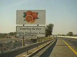 M-2 Motorway entering Sargodha District | |
 Flag  Seal | |
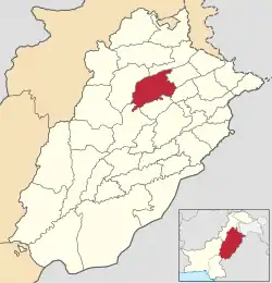 Location of Sargodha District in Punjab | |
| Country | |
| Province | |
| Division | Sargodha |
| Established | 1914 |
| Founded by | British Government |
| Headquarters | Sargodha |
| Government | |
| • Type | District Administration |
| • Deputy Commissioner | Muhammad Asghar Joiya |
| • District Police Officer | N/A |
| • District Health Officer | N/A |
| Area | |
| • District of Punjab | 5,854 km2 (2,260 sq mi) |
| Population (2017)[1] | |
| • District of Punjab | 3,703,588 |
| • Density | 630/km2 (1,600/sq mi) |
| • Urban | 1,144,535 |
| Time zone | UTC+5 (PST) |
| Postal Code | 40100 |
| Constituencies | NA-88, NA-89, NA-90, NA-91, NA-92 |
| Number of Tehsils | 7 |
| National Assembly Seats (2018) | Total (5)
|
| Punjab Assembly Seats (2018) | Total (10)
|
| Website | sargodha |
Etymology
It is believed that there was an old pond in the middle of the town where an old Hindu monk or sadhu (godha) used to live. The Sanskrit word for pond is "ser".[3] Since the town had a modest population, people would refer the place as 'ser godha', the place where that famous Sadhu resided next to the pond.[4]
Administration and tehsils
Sargodha city is the administrative headquarter of Sargodha Division and handles the population of about 8.1 million.[5] Sargodha District is administratively divided into Seven Tehsils, which contain a total of 161 Union Councils.[6] Following are the seven tehsils of Sargodha district:
Demographics
At the time of the 2017 census the district had a population of 3,696,212, of which 1,867,724 were males and 1,828,074 females. Rural population is 2,608,007 while the urban population is 1,144,535. The literacy rate was 65.54%.
Sargodha District is among the world's best Citrus-producing region. Sargodha District is well known for its kinnow, a citrus variety.[7]
The below list shows the population of each of the seven tehsils of Sargodha district according to the 2017 Census of Pakistan along with area:
| Tehsil | Population[1] (2017 Census) |
Area km2 (sqmi) |
|---|---|---|
| Sargodha[1] | 1,535,152 | 1,455 (561.8) |
| Kot Momin Tehsil[1] | 451,978 | 891 (344.0) |
| Bhalwal Tehsil[1] | 456,206 | 557 (215.1) |
| Shahpur[1] | 353,325 | 787 (303.9) |
| Silanwali[1] | 344,487 | 610 (235.5) |
| Sahiwal[1] | 340,695 | 759 (293.1) |
| Bhera Tehsil[1] | 314,369 | 722 (278.8) |
Religion
As per the 2017 census Muslims were the predominant religious community with 98.08% of the population while Christians were 1.76% of the population.[1]
| Religion | Population (1941)[8]: 42 | Percentage (1941) |
|---|---|---|
| Islam |
835,918 | 83.68% |
| Hinduism |
102,233 | 10.23% |
| Sikhism |
48,046 | 4.81% |
| Christianity |
12,620 | 1.26% |
| Others [lower-alpha 4] | 104 | 0.01% |
| Total Population | 998,921 | 100% |
Villages
Chak no 94 N.b Dhool sargodha
- Chak 101 NB
- Chak 104 SB
- Hathi Wind
- Ludewala
- Muzamabad Shareef
Notable people
- Shanti Swaroop Bhatnagar, an Indian colloid chemist, academic and scientific administrator
References
- "District Wise Results / Tables (Census - 2017) (see page 5 of 16 for Sargodha District)" (PDF). Pakistan Bureau of Statistics website. Archived from the original (PDF) on 7 November 2017. Retrieved 22 February 2023.
- "District Overview – Sargodha". Punjab Police, Government of the Punjab website. 4 January 2008. Archived from the original on 4 January 2008. Retrieved 22 February 2023.
- Portrait of Pakistan. Ferozsons. 1994. ISBN 9789690101051. Retrieved 31 December 2007.
The district derives its name for the headquarters town of Sargodha, which is a combination of "Sar" and "Godha". "Sar" is a Hindi word which denotes a water...
- Pakistan tourism directory. Holiday Weekly. 1997. Retrieved 31 December 2007.
Sargodha is a colony town established in 1903, but its origins are older. Sargodha is a combination of the words "Sar" meaning a pond and "Godha"...
- "DISTRICT WISE CENSUS RESULTS CENSUS 2017" (PDF). Pakistan Bureau of Statistics website. Archived from the original (PDF) on 29 August 2017. Retrieved 22 February 2023.
- "Tehsils & Unions in the District of Sargodha". National Reconstruction Bureau, Government of Pakistan website. Archived from the original on 9 February 2012. Retrieved 22 February 2023.
- Mahmood, Amjad (21 December 2020). "Sarghoda's citrus claim to fame". Dawn (newspaper). Retrieved 25 February 2023.
- "CENSUS OF INDIA, 1941 VOLUME VI PUNJAB PROVINCE". Retrieved 21 July 2022.
- Formerly known as Shahpur District, prior to district headquarters relocated to Sarghoda in 1960
- Historic district borders may not be an exact match in the present-day due to various bifurcations to district borders — which since created new districts — throughout the historic Punjab Province region during the post-independence era that have taken into account population increases.
- 1941 census: Including Ad-Dharmis
- Including Jainism, Buddhism, Zoroastrianism, Judaism, or not stated

