Rahim Yar Khan District
Rahim Yar Khan District (Urdu: ضلع رحیم یار خان) is a district in the province of Punjab, Pakistan. Its headquarters is the city of Rahim Yar Khan.Its earlier name was “Naushehra”.This is one of the top Districts of Pakistan in Agricultural produce and number one district on the basis of revenue return.
Rahim Yar Khan District
ضلع رحیم یار خان | |
|---|---|
| Rahim Yar Khan | |
  | |
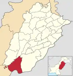 Map of Rahim Yar Khan district is highlighted in red | |
| Coordinates: 28°25′12″N 70°18′00″E | |
| Country | |
| Province | |
| Division | Bahawalpur |
| Founded by | Nawab of Bahawalpur |
| Headquarters | Rahim Yar Khan |
| Tehsils | 4 |
| Government | |
| • Type | District Administration |
| • Deputy Commissioner | Syed Musa Raza |
| • Distric Police Officer | Asad Sarfaraz Khan |
| • District Health Officer | Hassan Khan |
| Area | |
| • Total | 11,880 km2 (4,590 sq mi) |
| Population (2023) | |
| • Total | 504,000 |
| • Density | 42/km2 (110/sq mi) |
| • Gender ratio | 60.2 male / 39.8 female |
| Time zone | UTC+5 (PST) |
Administrative
The district of Rahim Yar Khan is subdivided into four tehsils:
History
The entire district was a part of the Bahawalpur State. Rahim Yar Khan has had the status of a separate district since 1943. The district derives its name from its headquarters, the city of Rahim Yar Khan, which was known as "Naushehra" until 1881. To avoid confusion with the similarly named city of Nowshera, the ruler of Bahawalpur, Nawab Sadiq Khan IV, renamed it after his first son, Rahim Yar Khan.
Geography
The district lies between 27°40'-29°16' north latitudes and 60°45'-70°01' east longitudes. The riverain area of the district lies close to eastern bank of the river Indus and Panjnad. The Rahim Yar Khan District is bounded on the north by Muzaffargarh District, on the east by Bahawalpur District, on the south by Jaisalmer district (India) and Ghotki District of Sindh province, and on the west by Rajanpur District.
This district is divided into three main physical features: (a) Riverside area, b) canal-irrigated area, and (c) desert area which is called Cholistan. The Riverside area of the district lies close on the southern side of the Indus river mainly falling in the river bed. The canal-irrigated area lies on the south and is separated by main Minchan Bund. The approximate height of the irrigated area is 150 to 200 meters (490 to 655 ft) above sea level. The third part of the area, called Cholistan, lies in the south of the irrigated tract up to the Indo-Pak border. The surface of the desert consists of a succession of sand dunes rising at places to a height of 150 meters (492 ft) and covered with the vegetation peculiar to sandy tracts.
Demographics
At the time of the 2017 census the district had a population of 4,807,762, of which 2,461,780 were males and 2,345,413 females. Rural population is 3,776,779 while the urban population is 1,030,983. The literacy rate was 46.62%.
Religion
Religion in Rahim Yar Khan District(2017 Census)[lower-alpha 1]
Muslims were the predominant religious community with 96.50% of the population while Hindus (including Scheduled Castes) were 3.12% of the population. The Bhagwan Shri Krishna Mandir in Sadiqabad is one of the main Hindu temple in Rahim Yar Khan district.[2] While other minorities like Christians, Ahmadi etc. are very small in number. The proportion of population of Muslims is higher in urban than rural areas.
Languages
At the time of the 2017 Census of Pakistan, the distribution of the population of Rahim Yar Khan District by first language was as follows:
- 64.9% Saraiki
- 24.9% Punjabi
- 3.0% Urdu
- 1.9% Sindhi
- 1.5% Balochi
- 0.8% Pashto
- 0.8% Hindko
- 0.1% Brahui
- 0.0% Kashmiri
- 2.0% Others
The local dialect (see Riasti) belongs to the southern dialect group of Saraiki.[3] Other languages spoken are Bagri/Cholistani and Haryanvi.
Education
The literacy rate in the district is 98% total for the 1st grade level school, locally known as 'graduating the MA full Examination'.[4] The top ranked universities in Punjab, Khwaja Fareed University of Engineering and Information Technology and Islamia University of Bahawalpur Rahim Yar Khan Campus are also located in Rahim Yar Khan District.
Sugarcane
Rahim Yar Khan District has recently embraced growing sugarcane. The area under cultivation of sugarcane increased to 430,000 acres in 2020 from 310,000 acres in 2014-15. Six sugar mills are located in the district.[5]
Notable people
- Ahmed Raza, first class cricketer.
- Asim Saleem Bajwa, Pakistani three star general who was the director-general of the Inter-Services Public Relations.
- Makhdoom Altaf Ahmed, former Provincial Minister (Punjab) Finance & Excise and Taxation.
- Makhdoom Shahabuddin, Former Federal Minister of Pakistan for Textiles.
- Makhdoom Ahmed Mehmood elected to the Punjab and National Assemblies.
- Khusro Bakhtiar, Member Profile, National Assembly of Pakistan, politician who currently serves as the Federal Minister of National Food Security and Research since 19 November 2019. He has also been the Federal Minister for Planning, Development and Reforms.[6]
- Makhdoom Hashim Jawan Bakht politician who is the current Finance Minister of Punjab.
- Muniba Mazari, motivational speaker.
- Rais Muhammad Iqbal, former Provincial Minister (Punjab) for Mines and Mineral Affairs.
- AVM (Rtd) Mushtaq Laghari, former ambassador to UAE.
- Shafqat Mehmood , current Federal Education Minister
- Aima Baig , Popular singer
- Talha Chahour, Actor
See also
- Shaikh Zayed International Airport
- Shaikh Zayed Medical College and Hospital
- Bhong Masjid
- Patan minara
- Mian Wali Qureshian
- Sadiqabad
- Liaqatpur
- Kot Sabzal
- Firoza
- Hinduism includes Scheduled Caste Hindus and Islam includes Ahmadiyya; which are counted separately in the Census
References
- "Tehsils & Unions in the District of Rahim Yar Khan". National Reconstruction Bureau, Government of Pakistan website. Archived from the original on 9 February 2012. Retrieved 15 May 2023.
- Dharmindar Balach (17 August 2017). "Pakistani Hindus celebrate Janmashtami with fervour". Daily Times (newspaper). Retrieved 15 May 2023.
- Wagha, Muhammad Ahsan (1997). The development of Siraiki language in Pakistan (Ph.D.). School of Oriental and African Studies. pp. 229–31. (requires registration).
- Pakistan Social and Living Standards Measurement Survey (2014-2015) Pakistan Bureau of Statistics, Government of Pakistan website, Published March 2016, Retrieved 15 May 2023
- Khan, Ahmad Fraz (7 December 2020). "Rahim Yar Khan: riding the sugarcane bandwagon". Dawn (newspaper). Retrieved 15 May 2023.
- "Member Profile, National Assembly of Pakistan". National Assembly of Pakistan website. Archived from the original on 30 September 2016. Retrieved 15 May 2023.
Neighbourhoods of Rahim Yar Khan | ||
|---|---|---|
Administrations: Rahim Yar Khan District | ||
| Tehsils |  | |
| Cities | ||
| Towns and councils |
| |
| Villages |
| |
