Faisalabad District
Faisalabad District (Lyallpur District until 1979)[3] (Punjabi and Urdu: ضلع فیصل آباد) is one of the districts of Punjab province, Pakistan. According to the 1998 census of Pakistan it had a population of 3,029,547 of which almost 42% were in Faisalabad City. It is the third largest city of Pakistan after Karachi and Lahore.[4]
Faisalabad District
ضلع فیصل آباد Lyallpur | |
|---|---|
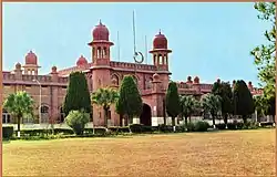  Top: University of Agriculture, Faisalabad Bottom: Gat Wala Lake | |
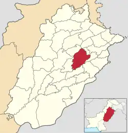 Faisalabad District highlighted within Punjab Province | |
| Coordinates: 31°25′05.10″N 73°04′39.27″E | |
| Country | Pakistan |
| Province | Punjab |
| Division | Faisalabad |
| Headquarters | Faisalabad |
| Number of Tehsils | 6 |
| Government | |
| • Type | District Administration |
| • Deputy Commissioner | Imran Hamid Shaikh[1] |
| • District Police Officer | N/A |
| • District Health Officer | N/A |
| Area | |
| • Total | 5,857 km2 (2,261 sq mi) |
| Population (2017)[2] | |
| • Total | 7,874,790 |
| • Density | 1,300/km2 (3,500/sq mi) |
| Time zone | UTC+5 (PST) |
| Languages | Punjabi, Urdu |
| Website | faisalabad |
After the independence of Pakistan in 1947, the Muslim refugees from Eastern Punjab and Haryana settled in the Faisalabad District. It initially lacked industry, hospitals and universities. Since independence, there has been industrial growth, and the city's population is continually growing. Notable industry in the district include but not limited to Textile (spinning, weaving, printing, dying, stitching), Chemicals (acids, caustics, industrial gases, potash, chlorides, etc.), consumer goods (soaps, vegetable oil, detergents), Engineering (light electrical equipment, engineering goods), Metals & Metallurgy (steels, alloys) and Power (power equipment, power production).[5]
Initially a part of Jhang District, it gained the status of a separate district in 1904.[6] In 1982 Toba Tek Singh District (until then a Tehsil of Faisalabad District) was created as a separate district from Faisalabad. As of 2006, it is a City-District consisting of the city of Faisalabad and its surrounding areas.[7]
Administrative divisions
Faisalabad District is part of Faisalabad Division.
In 2005 Faisalabad was reorganized as a City-District. It comprises six Tehsils.[8][7]
Demographics
At the time of the 2017 census, the district had a population of 7,874,790.[2]
| Administrative Unit | 1981[9] | 1998[9] | 2017[2] |
|---|---|---|---|
| Chak Jhumra | 202,078 | 253,806 | 332,461 |
| Faisalabad City | 1,181,562 | 2,140,346 | 3,238,841 |
| Faisalabad Sadar | 666,023 | 924,110 | 1,465,411 |
| Jaranwala | 747,890 | 1,054,698 | 1,492,276 |
| Samundri | 378,302 | 515,785 | 643,068 |
| Tandlianwala | 386,054 | 540,802 | 702,733 |
| Faisalabad District | 3,561,909 | 5,429,547 | 7,874,790 |
Religion
As per the 2017 census, Muslims were the predominant religious community with 96.49% of the population while Christians were 3.36% of the population.[10]
| Religion | Population (1941)[11]: 42 | Percentage (1941) |
|---|---|---|
| Islam |
877,518 | 62.85% |
| Sikhism |
262,737 | 18.82% |
| Hinduism |
204,059 | 14.61% |
| Christianity |
51,694 | 3.7% |
| Others [lower-alpha 4] | 297 | 0.02% |
| Total Population | 1,396,305 | 100% |
Transportation
Road
Rail
Air
Education
Punjab Group of Colleges (Girls Campus) Service Road
Punjab Group of Colleges (Boys Campus) Service Road
Notable people
- Bhagat Singh, a famous Indian revolutionary and freedom fighter
- Om P. Bahl, an Indian-American molecular biologist, academic and was known for his studies on Human chorionic gonadotropin, popularly known as the pregnancy hormone
- Harkishan Singh, a well recognized pharmaceutical academic, medicinal chemistry researcher and science historian
- Lal Chand Yamla Jatt, a noted Indian Punjabi-language folk singer, considered by many to have laid the foundation of contemporary Punjabi music in India
- Arjan Singh, a senior air officer and the first and only officer of the Indian Air Force (IAF) to be promoted to five-star rank as Marshal of the Indian Air Force
See also
References
- "DC Directs Polio Teams To Remain Active For Achieving Target". UrduPoint. 21 January 2023. Retrieved 22 January 2023.
- "District And Tehsil Level Population Summary With Region Breakup (Faisalabad District)" (PDF). Pakistan Bureau of Statistics, Government of Pakistan website. Archived from the original (PDF) on 23 November 2018. Retrieved 13 April 2023.
- "History of Faisalabad". Punjab Portal website. Archived from the original on 18 October 2015. Retrieved 13 April 2023.
- Urban Resource Centre (1998 census details) Archived 13 May 2006 at the Wayback Machine
- "A Histroty of Faisalabad City". Faisalabad Chamber of Commerce and Industry website. Archived from the original on 22 May 2017. Retrieved 13 April 2023.
- 1998 District Census report of Faisalabad. Census publication. Vol. 116. Islamabad: Population Census Organization, Statistics Division, Government of Pakistan. 2000.
- "Towns & Unions in the City Disrict of Faisalabad". National Reconstruction Bureau, Government of Pakistan website. Archived from the original on 26 March 2012. Retrieved 13 April 2023.
- "Faisalabad, Punjab Portal". punjab.gov.pk. Retrieved 3 March 2021.
- "1951-1998 censuses" (PDF). pbs.gov.pk. Retrieved 3 March 2021.
- "District Wise Results / Tables (Census - 2017)". www.pbscensus.gov.pk. Pakistan Bureau of Statistics.
- "CENSUS OF INDIA, 1941 VOLUME VI PUNJAB PROVINCE". Retrieved 22 July 2022.
- Formerly known as Lyallpur District, prior to district renaming in 1979.
- Historic district borders may not be an exact match in the present-day due to various bifurcations to district borders — which since created new districts — throughout the historic Punjab Province region during the post-independence era that have taken into account population increases.
- 1941 census: Including Ad-Dharmis
- Including Jainism, Buddhism, Zoroastrianism, Judaism, or not stated
External links

Places adjacent to Faisalabad District | ||||||||||||||||
|---|---|---|---|---|---|---|---|---|---|---|---|---|---|---|---|---|
| ||||||||||||||||
