Narowal District
Narowal District (Punjabi and Urdu: ضِلع نارووال), is a district in the province of Punjab of Pakistan. Narowal city is the capital of the district. During the British rule, Narowal was the town of Raya Khas tehsil of Sialkot District. Narowal District formed in 1991, when the two tehsils of Narowal and Shakargarh were split off from Sialkot District.[2]
Narowal District
ضِلع نارووال | |
|---|---|
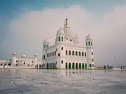 Gurudwara Darbar Singh, Kartarpur | |
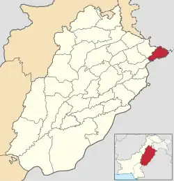 Map of Narowal in Punjab | |
| Country | |
| Province | |
| Division | Gujranwala |
| Headquarters | Narowal |
| Government | |
| • Type | District Administration |
| • Deputy Commissioner | N/A |
| • District Police Officer | N/A |
| • District Health Officer | N/A |
| Area | |
| • Total | 2,337 km2 (902 sq mi) |
| Population (2017)[1] | |
| • Total | 1,707,575 |
| • Density | 730/km2 (1,900/sq mi) |
| Time zone | UTC+5 (PST) |
| Number of Tehsils | 3 |
| Website | narowal |
Administration
The district is administratively divided into the following three tehsils (subdivisions), which contain a total of 74 Union Councils:[3]
| Tehsil | No. of Unions |
|---|---|
| Narowal | 28 |
| Shakargarh | 28 |
| Zafarwal | 26 |
| Total | 82 |
Geography
The district is bounded by on the northwest by Sialkot, by India on the north by Kathua district of Jammu and Kashmir, on the southeast by the Gurdaspur district and Pathankot district, on the south by Amritsar district, and on the southwest by Sheikhupura district in Pakistan.
The total area of the district is approximately 4,623 square kilometres. Prior to the creation of Zafarwal Tehsil in July 2009,[4] Narowal Tehsil occupied 1,065 square kilometres while the remaining area (1,272 square kilometres) fell in Shakargarh Tehsil. According to the 1998 census of Pakistan, Narowal District's population was 1,256,097, of which only 12.11% were urbans.[5] According to the 2017 census, total population of District Narowal is 1.709 million. Male population is 0.853 m (49.96%) and Female population is 0.855 m (50.04%).
Demography
According to the 2017 census, the population was 1,707,575 of which 1,450,918 (84.97%) was rural and 256,657 (15.03%) was urban. Muslims made up 97.42% of the population while Christians were 2.22% of the population.[1]
Language
At the time of the 2017 census, 97.24% of the population spoke Punjabi and 1.66% Urdu as their first language.[1]
Religion
| Religion | Population (1941)[6]: 60 | Percentage (1941) |
|---|---|---|
| Islam |
149,600 | 51.32% |
| Hinduism |
116,553 | 39.98% |
| Sikhism |
20,573 | 7.06% |
| Christianity |
4,779 | 1.64% |
| Total Population | 291,505 | 100% |
Notable people
- Dev Anand, Bollywood actor, director & producer
- Muhammad Tariq Anis : Ex MPA and MNA
- Daniyal Aziz, State Minister of Broadcasting
- Shiv Kumar Batalvi, Punjabi poet
- Anwar Aziz Chaudhry, politician
- Ijaz Ahmed Chaudhry, justice
- Faiz Ahmad Faiz, Pakistani revolutionary poet.[7]
- Abrar-ul-Haq, singer-songwriter, philanthropist, politician
- Syed Saeed ul Hassan, Minister of Punjab for Auqaf and Religious Affairs
- Adnan Ilyas, cricketer
- Ahsan Iqbal, Interior Minister of Pakistan
- Chaudhry Muhammad Sarwar Khan, longest serving Parliamentarian in the history of Pakistan.
- Rajendra Kumar, film actor, director, producer, recipient of Padma Shri (1969)
- Naseer Ahmad Malhi, one of the founding fathers of Pakistan and the first education minister of Pakistan
- Chaudhry Abdul Rahim, politician
- Des Raj, cricket umpire
- Afzal Ahsan Randhawa, writer
- Gurbachan Singh Salaria, Indian Army Officer
- Kidar Sharma, Indian film director, producer, screenwriter, and Lyricist of Hindi films.
- Z. A. Suleri, political journalist
References
- "District census 2017 - Narowal". Pakistan Bureau of Statistics.
- "Narowal - Punjab Portal". Retrieved 15 December 2016.
- "Tehsils & Unions in the District of Narowal". National Reconstruction Bureau, Government of Pakistan. Archived from the original on 1 April 2008.
- "Zafarwal to become tehsil on July 1". Dawn. 2 February 2009. Retrieved 25 May 2010.
- Urban Resource Centre - Population table Archived 2006-05-13 at the Wayback Machine
- "CENSUS OF INDIA, 1941 VOLUME VI PUNJAB PROVINCE". Retrieved 21 August 2022.
- "His family". Dawn. Pakistan. 11 February 2011. Retrieved 20 October 2019.
- 1941 figures are for Shakargarh Tehsil, which roughly matches present-day district borders. District was incorporated to take into account population increases during the post-independence era, which has resulted in various bifurcations of districts and tehsils across the historic Punjab Province region.
- 1941 census: Including Ad-Dharmis
