Vehari District
Vehari District (Urdu and Punjabi: ضلع وہاڑی) is a district in the Punjab province of Pakistan. The city of Vehari is the capital of district while Burewala is the largest city of the district.[1]
Vehari District
ضلع وہاڑی | |
|---|---|
.jpg.webp)  | |
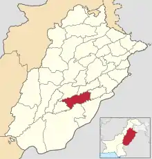 Map of Punjab with Vehari District highlighted | |
| Country | |
| Province | |
| Division | Multan |
| Headquarters | Vehari |
| Government | |
| • Type | District Administration |
| • Deputy Commissioner | Syed Asif Shah |
| • District Police Officer | Muhammad Essa Khan Sukhera |
| • District Health Officer | N/A |
| Area | |
| • Total | 4,364 km2 (1,685 sq mi) |
| Population | |
| • Total | 2,897,446 |
| • Density | 660/km2 (1,700/sq mi) |
| Time zone | UTC+5 (PST) |
| Website | vehari |
Administrative divisions
The district of Vehari is administratively subdivided into three tehsils:[3]
and three subtehsils:
- Gaggo
- Machiwal
- Karam Pur
- Jallah Jeem
History
The district was created on 1 July 1976 out of the three tehsils of Multan District (Vehari, Burewala and Mailsi). The name Vehari means low-lying settlement by a flood water channel. The district lies along the right bank of the river Sutlej, which forms its southern boundary.[4]
Demographics
At the time of the 2017 census the district had a population of 2,897,446, of which 1,463,796 were males and 1,437,989 females. Rural population is 2,395,952 while the urban population is 506,129. The literacy rate was 55.36%. Muslims were the predominant religious community with 99.31% of the population while Christians were 0.65% of the population.[2]
At the time of the 2017 census, 74.69% of the population spoke Punjabi, 19.18% Saraiki and 5.12% Urdu as their first language.
Geography
The district is located between 29°36′N 71°44′E and 30°22′N 72°53′E and borders with Bahawalnagar and Bahawalpur on the southern side, with Pakpattan on the eastern, with Khanewal and Lodhran on western and with Sahiwal and Khanewal on northern side.
The total area of the district is 4,364 square kilometres (1,685 sq mi). It is about 93 kilometres (58 mi) in length and approximately 47 kilometres (29 mi) in breadth and it is sloping gently from northeast to southwest.
Agriculture
141,000 acres of area was growing maize in 2015-16, increasing to 309,000 acres in 2019-20. The total production of maize stood at 428,000 tonnes in 2015-16, and rose to 1.1 million tonnes in 2019-20.[5]
Notable people
- Mohammad Irfan, cricketer
- Chaudhry Nazir Ahmed Jatt, politician, member National Assembly of Pakistan from Vehari District[6]
- Tufail Mohammad of Punjab Regiment, recipient of Nishan-e-Haider
- Saleem Sherwani, hockey player
- Waqar Younis, cricketer
References
- "PAKISTAN: Punjab: Population of Districts". Citypopulation.de website. Archived from the original on 29 April 2020. Retrieved 30 May 2023.
- "District Wise Results / Tables (Census - 2017) (scroll down to Vehari District)" (PDF). Pakistan Bureau of Statistics, Government of Pakistan website. Archived from the original (PDF) on 7 November 2017. Retrieved 30 May 2023.
- "Tehsils & Unions in the District of Vehari". National Reconstruction Bureau, Government of Pakistan website. Archived from the original on 5 August 2012. Retrieved 30 May 2023.
- Khan, Ahmad Fraz (18 January 2021). "Multan's mangoes and multinationals". Dawn (newspaper). Retrieved 30 May 2023.
- Khan, Ahmad Fraz (28 December 2020). "Vehari's tale of transition: from cotton to maize and livestock". Dawn (newspaper). Retrieved 30 May 2023.
- "Eid-i-Milad celebrated with fervour". The Nation (newspaper). Archived from the original on 6 March 2017. Retrieved 30 May 2023.
External links
Neighbourhoods of Vehari | ||
|---|---|---|
Administrations: Vehari District | ||
| Tehsils |  | |
| Cities | ||
| Towns and councils | ||
| Villages | ||
Website: Vehari District | ||
