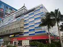
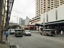
Chino Roces Avenue
Chino Roces Avenue, formerly known as (and still commonly referred to as) Pasong Tamo, is a prominent north–south road in the cities of Makati and Taguig, Metro Manila, Philippines It runs for 5.80 kilometers (3.60 miles) from Olympia and Tejeros to Fort Bonifacio.[1] The avenue is named after Joaquin "Chino" Roces, journalist, founder of The Manila Times and Associated Broadcasting Company (now TV5), and an opposition figure during the Marcos Sr. administration. The fact that the avenue is the location of various media establishments influenced the renaming.[2][3]
| Pasong Tamo | |
 Chino Roces Avenue northbound towards Don Bosco | |
| Namesake | Joaquin "Chino" Roces |
|---|---|
| Type | Tertiary road[1] |
| Maintained by | Department of Public Works and Highways - Metro Manila 2nd District Engineering Office[1] |
| Length | 5.80 km (3.60 mi)[1] Includes 2.12 km (1.32 mi) extension south of EDSA |
| Location | Makati and Taguig |
| North end | J. P. Rizal Avenue and A.P. Reyes Avenue in Tejeros and Olympia, Makati |
| Major junctions | Kalayaan Avenue Ocampo Street Dela Rosa Street Arnaiz Avenue |
| South end | Lawton Avenue in Fort Bonifacio, Taguig |
The northern end of Chino Roces Avenue is at the intersection with J. P. Rizal Avenue. It heads southwesterly across the residential and commercial barangays of Olympia, Tejeros, Santa Cruz, and La Paz. After the intersection with Yakal Street in San Antonio, the avenue bends to the south, becoming more commercial as it approaches Gil Puyat Avenue. The road continues southwards through the western limits of the Makati CBD, bending slightly southwesterly between Dela Rosa and Don Bosco Streets. The avenue then becomes mixed commercial and industrial as it continues on a straight route to EDSA.
South of EDSA via a narrow channel under the Magallanes Interchange, its extension serves as a frontage road to South Luzon Expressway. It is lined with light industries and car dealerships on both sides, as well as a few factory outlets, in an area also known as Mantrade or Kayamanan-C.[4] The road ends at Lawton Avenue within Fort Bonifacio in Taguig, near Sales Interchange. Chino Roces has a short extension north of J. P. Rizal Avenue into Barangay Carmona as A. P. Reyes Avenue. The part of Chino Roces from Rufino Street to Arnaiz Avenue is home to several Japanese restaurants and shops, earning it the nickname "Little Tokyo".[5]
History
The avenue originated as a short street in what was historically known as Malolos Subdivision, a residential subdivision in Tejeros and Olympia.[6] As suggested by surrounding streets in such area named similar to places that played significant roles during the Philippine Revolution (e.g. Malolos, Barasoain, Novaliches, Binakod, Zapote), Pasong Tamo may be named after a barrio in Caloocan (now a barangay in the present-day Quezon City) where the Battle of Pasong Tamo occurred. Its name also comes from an indigenous plant called tamo that once grew there abundantly.[7] It was then extended towards Ocampo Street in the 1940s and later towards southern Makati circa 1950s,[7] making it a major road.[4][8][9] It was later extended south of EDSA towards Taguig.[10]
Landmarks


- Avida Towers San Lorenzo
- Alphaland Southgate Mall and Tower
- Alegria Building
- Cityland Pasong Tamo Tower
- CW Home Depot
- Directories Philippines Corporation (publisher of the Philippine Yellow Pages)
- Don Bosco Technical Institute, Makati
- DPI XL Studios
- Ecoplaza Building
- Eurotel Makati
- Exportbank Plaza
- Green Sun
- Kingswood Towers
- Little Tokyo
- Laureano De Trevi Towers by Vista Residences
- Leelin Building
- Makati Hope Christian School
- Makati Central Square (formerly Makati Cinema Square)
- Mantrade
- Mazda Makati
- Molave Building
- National Nutrition Council Nutrition Building
- New Senate Building (under construction)
- Oriental Garden Condominium
- Philippine Daily Inquirer Building
- San Lorenzo Place
- Shopwise Makati
- The Oriental Place
- SM Savemore Pasong Tamo
- The Beacon – Roces Tower
- WalterMart Makati
- Wilcon Depot IT Hub
References
- "Metro Manila 2nd". Department of Public Works and Highways. Retrieved November 7, 2020.
- "A resolution renaming Pasong Tamo Street" (PDF). Makati City Government. Retrieved October 11, 2013.
- "Evolution of Chino Roces". Inquirer.net. March 30, 2019. Retrieved February 26, 2022.
- Map : Makati, Philippines 1968, Map of municipality of Makati, Province of Rizal, Philippines (Map). 1:10000. Antique Vintage Reproduction. 1968. Retrieved February 26, 2022.
- The best of Little Tokyo Archived October 16, 2013, at the Wayback Machine published by Philippine Daily Inquirer; accessed October 11, 2013.
- Map of Manila and Suburbs (Map). 1:20,000. The Chief of Engineers, Washington, D.C. 1943. Retrieved March 5, 2022.
- Castro, Alex (September 12, 2017). "These Photos of Makati From the Past Will Amaze You". Spot.ph. Retrieved March 5, 2022.
- "Vertical view of Nielson Field in Makati area of southern Manila". PacificWrecks. Retrieved September 21, 2021.
- Manila City Plan (Map). 1943. Retrieved March 5, 2022.
- Manila and Quezon City (Map). 1:50,000. S711. Washington D.C.: Army Map Service, Corps of Engineers. 1964. Retrieved July 10, 2023.
External links
 Media related to Chino Roces Avenue (San Lorenzo, Pio del Pilar, Tejeros & La Paz, Makati City) at Wikimedia Commons