Christmas Card Lane
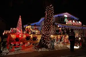
Christmas Card Lane is a holiday light display in San Diego, California in the community of Rancho Penasquitos. It is one of the most famous holiday displays in San Diego.[1][2][3][4] Residents erect giant plywood greetings in their front yards depicting cartoon characters, religious images, or Christmas themes.

History
Christmas Card Lane was started in 1982 by resident Alana Hastings as a way to share the Christmas spirit of the tight-knit community with others in the city.[5] Residents began to call local radio stations to advertise Christmas Card Lane.[5] Initially 15 families on Ellingham Street participated. Now there are about 200, spreading onto Oviedo and Renato streets.[1]
Displays range from Mickey Mouse representing the noted "Christmas Carol" story, to testing out the new naughty-or-nice software. Some displays are so elaborate that residents keep parts up all year.[6][7] School and scouting organizations often sell baked goods and hot chocolate, and members of the local school bands play Christmas carols, while other organizations rent horse-drawn carriages, double decker buses, or limousines: groups sing carols while driving around the neighborhood.[5]
The displays start going up right after Thanksgiving, with most in place by the second week of December and staying there through New Year's. Some displays require weeks of preparation.[5]
References
- Sherman, Pat (2004-12-24). "Christmas Card Lane is town's version of North Pole". San Diego Union Tribune.
- North County Times/The Californian - Jeff Frank
- Christmas Light Displays Around San Diego
- Rancho Penasquitos, San Diego, California: Information and Much More from Answers.com
- Lopez, Jose (December 7, 2006). "Christmas Card Lane lights up Rancho Penasquitos". Pomerado Newspaper Group. Retrieved 2007-12-22.
- McKinley, Shay (2000-12-15). "Christmas cards draw a festive crowd". San Diego Union Tribune.
- McKinley, Shay (2001-12-15). "Light display infused with red, white and blue". San Diego Union Tribune.