Gamvik
ⓘ (Northern Sami: Gáŋgaviika) is a municipality in Troms og Finnmark county, Norway. The administrative centre of the municipality is the village of Mehamn. The other main villages in Gamvik include Gamvik and Skjånes. Gamvik is known as one of the poorest and most undeveloped municipalities in Norway. The number of inhabitants rose at one moment in 2012, but in 2014, after the fish factory closed, the population declined dramatically with the departure of the eastern European fishermen.
Gamvik kommune
Gáŋgaviikka gielda | |
|---|---|
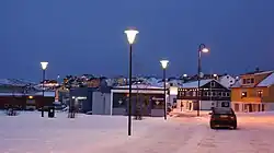 View of Mehamn on New Year's Day (during the polar night) | |
 Flag  Troms og Finnmark within Norway | |
 Gamvik within Troms og Finnmark | |
| Coordinates: 71°02′28″N 27°51′05″E | |
| Country | Norway |
| County | Troms og Finnmark |
| District | Øst-Finnmark |
| Established | 1 Jan 1914 |
| • Preceded by | Tana Municipality |
| Administrative centre | Mehamn |
| Government | |
| • Mayor (2019) | Alf Normann Hansen (SV) |
| Area | |
| • Total | 1,416.34 km2 (546.85 sq mi) |
| • Land | 1,354.87 km2 (523.12 sq mi) |
| • Water | 61.47 km2 (23.73 sq mi) 4.3% |
| • Rank | #65 in Norway |
| Population (2022) | |
| • Total | 1,057 |
| • Rank | #329 in Norway |
| • Density | 0.8/km2 (2/sq mi) |
| • Change (10 years) | |
| Demonyms | Gamviking Gamvikværing[1] |
| Official language | |
| • Norwegian form | Neutral |
| Time zone | UTC+01:00 (CET) |
| • Summer (DST) | UTC+02:00 (CEST) |
| ISO 3166 code | NO-5439 |
| Website | Official website |

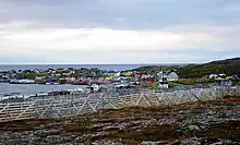
Most people live in the village of Mehamn (about 500 inhabitants), which has an airport, Mehamn Airport, and is also a port of call of the hurtigruten coastal boats. The Slettnes Lighthouse near the village of Gamvik is the northernmost lighthouse on the mainland of Europe. Nervei and Langfjordbotn are two very small villages in southern Gamvik that are only accessible by boat. Finnkongkeila is an abandoned village along the Tanafjorden.
The 1,416-square-kilometre (547 sq mi) municipality is the 65th largest by area out of the 356 municipalities in Norway. Gamvik is the 329th most populous municipality in Norway with a population of 1,057. The municipality's population density is 0.8 inhabitants per square kilometre (2.1/sq mi) and its population has increased by 4.9% over the previous 10-year period.[3][4]
General information
The municipality of Gamvik was established on 1 January 1914 when the old Tana Municipality was divided into three municipalities: Tana (population: 1,426) in the south, Berlevåg (population: 784) in the northeast, and Gamvik (population: 1,371) in the northwest. The municipal boundaries have not changed since that time.[5]
On 1 January 2020, the municipality became part of the newly formed Troms og Finnmark county. Previously, it had been part of the old Finnmark county.[6]
Name
The Old Norse form of the name may have been Gangvík. The first element is then gangr which means "path" and the last element is vík which means "cove" or "wick".[7]
Coat of arms
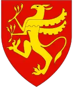
The coat of arms was granted on 28 September 1990. The official blazon is "Gules, three net needles Or in bend sinister" (Norwegian: I rødt tre skråstilte gule garnnåler). This means the arms have a red field (background) and the charge is three fishing net sewing needles that are arranged diagonally. The net needles have a tincture of Or which means it is commonly colored yellow, but if it is made out of metal, then gold is used. These needles are a characteristic maritime tool used for making and mending the fishing nets used by local fishermen. These arms were chosen to emphasize the importance of fishing in the area.[8][9][10]
Churches
The Church of Norway has one parish (sokn) within the municipality of Gamvik. It is part of the Hammerfest prosti (deanery) in the Diocese of Nord-Hålogaland.
| Parish (sokn) | Church name | Location of the church | Year built |
|---|---|---|---|
| Gamvik | Gamvik Church | Gamvik | 1958 |
| Hop Church | Skjånes | 1977 | |
| Mehamn Chapel | Mehamn | 1965 |
History
In June 1972 construction started for [a landside terminal and] running a SOSUS cable into the sea.[11] The SOSUS station was one of more than twenty worldwide.[11]
1982 air crash
On 12 March 1982, a Widerøe Twin Otter, registration number LN-BNK, crashed into the sea near Mehamn, killing all fifteen on board. More than twenty years and four rounds of investigation later, this incident remained highly controversial in Norway.
Government
All municipalities in Norway, including Gamvik, are responsible for primary education (through 10th grade), outpatient health services, senior citizen services, unemployment and other social services, zoning, economic development, and municipal roads. The municipality is governed by a municipal council of elected representatives, which in turn elect a mayor.[12] The municipality falls under the Øst-Finnmark District Court and the Hålogaland Court of Appeal.
Municipal council
The municipal council (Kommunestyre) of Gamvik is made up of 13 representatives that are elected to four year terms. The party breakdown of the council is as follows:
| Party Name (in Norwegian) | Number of representatives | |
|---|---|---|
| Labour Party (Arbeiderpartiet) | 6 | |
| Progress Party (Fremskrittspartiet) | 1 | |
| Centre Party (Senterpartiet) | 2 | |
| Socialist Left Party (Sosialistisk Venstreparti) | 4 | |
| Total number of members: | 13 | |
| Party Name (in Norwegian) | Number of representatives | |
|---|---|---|
| Labour Party (Arbeiderpartiet) | 7 | |
| Progress Party (Fremskrittspartiet) | 2 | |
| Socialist Left Party (Sosialistisk Venstreparti) | 4 | |
| Total number of members: | 13 | |
| Party Name (in Norwegian) | Number of representatives | |
|---|---|---|
| Labour Party (Arbeiderpartiet) | 5 | |
| Progress Party (Fremskrittspartiet) | 1 | |
| Conservative Party (Høyre) | 2 | |
| Socialist Left Party (Sosialistisk Venstreparti) | 3 | |
| Cross-Party List (Tverrpolitisk liste) | 2 | |
| Total number of members: | 13 | |
| Party Name (in Norwegian) | Number of representatives | |
|---|---|---|
| Labour Party (Arbeiderpartiet) | 9 | |
| Conservative Party (Høyre) | 3 | |
| Socialist Left Party (Sosialistisk Venstreparti) | 1 | |
| Total number of members: | 13 | |
| Party Name (in Norwegian) | Number of representatives | |
|---|---|---|
| Labour Party (Arbeiderpartiet) | 8 | |
| Socialist Left Party (Sosialistisk Venstreparti) | 5 | |
| Total number of members: | 13 | |
| Party Name (in Norwegian) | Number of representatives | |
|---|---|---|
| Labour Party (Arbeiderpartiet) | 9 | |
| Socialist Left Party (Sosialistisk Venstreparti) | 2 | |
| Cross-Party List (Tverrpolitisk liste) | 2 | |
| Total number of members: | 13 | |
| Party Name (in Norwegian) | Number of representatives | |
|---|---|---|
| Labour Party (Arbeiderpartiet) | 8 | |
| Socialist Left Party (Sosialistisk Venstreparti) | 2 | |
| Cross-Party List (Tverrpolitisk liste) | 6 | |
| Fjoran Cross-Party List (Fjoran Tverrpolitiske liste) | 1 | |
| Total number of members: | 17 | |
| Party Name (in Norwegian) | Number of representatives | |
|---|---|---|
| Labour Party (Arbeiderpartiet) | 6 | |
| Socialist Left Party (Sosialistisk Venstreparti) | 4 | |
| Cross-Party List (Tverrpolitisk liste) | 7 | |
| Total number of members: | 17 | |
| Party Name (in Norwegian) | Number of representatives | |
|---|---|---|
| Labour Party (Arbeiderpartiet) | 9 | |
| Socialist Left Party (Sosialistisk Venstreparti) | 2 | |
| Cross-Party List (Tverrpolitisk liste) | 6 | |
| Total number of members: | 17 | |
| Party Name (in Norwegian) | Number of representatives | |
|---|---|---|
| Labour Party (Arbeiderpartiet) | 11 | |
| Conservative Party (Høyre) | 1 | |
| Socialist Left Party (Sosialistisk Venstreparti) | 1 | |
| Cross-Party Common List (Tverrpolitisk fellesliste) | 4 | |
| Total number of members: | 17 | |
| Party Name (in Norwegian) | Number of representatives | |
|---|---|---|
| Labour Party (Arbeiderpartiet) | 11 | |
| Cross-Party Common List (Tverrpolitisk fellesliste) | 6 | |
| Total number of members: | 17 | |
| Party Name (in Norwegian) | Number of representatives | |
|---|---|---|
| Labour Party (Arbeiderpartiet) | 12 | |
| Christian Democratic Party (Kristelig Folkeparti) | 1 | |
| Common List for Gamvik and Fjord district (Fellesliste for Gamvik og Fjorddistrikt) | 3 | |
| Mehamn Free Voter List (Mehamn Frie Velgeres Liste) | 1 | |
| Total number of members: | 17 | |
| Party Name (in Norwegian) | Number of representatives | |
|---|---|---|
| Labour Party (Arbeiderpartiet) | 7 | |
| Joint List(s) of Non-Socialist Parties (Borgerlige Felleslister) | 2 | |
| Local List(s) (Lokale lister) | 8 | |
| Total number of members: | 17 | |
| Party Name (in Norwegian) | Number of representatives | |
|---|---|---|
| Labour Party (Arbeiderpartiet) | 7 | |
| List of workers, fishermen, and small farmholders (Arbeidere, fiskere, småbrukere liste) | 8 | |
| Joint List(s) of Non-Socialist Parties (Borgerlige Felleslister) | 2 | |
| Total number of members: | 17 | |
| Party Name (in Norwegian) | Number of representatives | |
|---|---|---|
| Labour Party (Arbeiderpartiet) | 8 | |
| Conservative Party (Høyre) | 1 | |
| Liberal Party (Venstre) | 1 | |
| List of workers, fishermen, and small farmholders (Arbeidere, fiskere, småbrukere liste) | 7 | |
| Total number of members: | 17 | |
| Party Name (in Norwegian) | Number of representatives | |
|---|---|---|
| Labour Party (Arbeiderpartiet) | 5 | |
| List of workers, fishermen, and small farmholders (Arbeidere, fiskere, småbrukere liste) | 11 | |
| Local List(s) (Lokale lister) | 1 | |
| Total number of members: | 17 | |
| Party Name (in Norwegian) | Number of representatives | |
|---|---|---|
| List of workers, fishermen, and small farmholders (Arbeidere, fiskere, småbrukere liste) | 3 | |
| Local List(s) (Lokale lister) | 14 | |
| Total number of members: | 17 | |
| Party Name (in Norwegian) | Number of representatives | |
|---|---|---|
| List of workers, fishermen, and small farmholders (Arbeidere, fiskere, småbrukere liste) | 3 | |
| Local List(s) (Lokale lister) | 13 | |
| Total number of members: | 16 | |
| Party Name (in Norwegian) | Number of representatives | |
|---|---|---|
| Labour Party (Arbeiderpartiet) | 6 | |
| List of workers, fishermen, and small farmholders (Arbeidere, fiskere, småbrukere liste) | 9 | |
| Local List(s) (Lokale lister) | 1 | |
| Total number of members: | 16 | |
| Party Name (in Norwegian) | Number of representatives | |
|---|---|---|
| List of workers, fishermen, and small farmholders (Arbeidere, fiskere, småbrukere liste) | 16 | |
| Total number of members: | 16 | |
| Party Name (in Norwegian) | Number of representatives | |
|---|---|---|
| Labour Party (Arbeiderpartiet) | 10 | |
| Joint List(s) of Non-Socialist Parties (Borgerlige Felleslister) | 6 | |
| Total number of members: | 16 | |
| Note: Due to the German occupation of Norway during World War II, no elections were held for new municipal councils until after the war ended in 1945. | ||
Geography
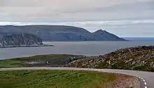
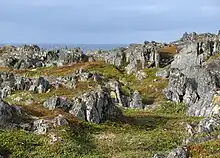
The municipality consists of the eastern half of the Nordkinn Peninsula. Kinnarodden, located in Gamvik, is the northernmost point of mainland Europe (the more well-known North Cape is located nearby on Magerøya island). The Tanafjorden flows along the eastern coast of Gamvik. Lebesby Municipality is located to the west and Tana Municipality is located to the south. Across the fjord to the east is Berlevåg Municipality.
Climate
The inhabited places of Gamvik, such as Mehamn, has a boreal climate (Köppen climate classification: Dfc). The spring is very late to warm up and is among the coldest in Norway. Summers are short and cool. Winters are moderated by the Barents Sea and only slightly colder than in the capital Oslo. However, winds can be strong in winter. Slettnes Lighthouse, located on an exposed headland in the northern part of the municipality, is the only remaining weather station in mainland Norway with a tundra climate with the 1991-2020 normals. The all-time high in Gamvik municipality is 32.2 °C (90.0 °F) recorded at Slettnes Lighthouse in July 1972, and the second warmest is 31.4 °C (88.5 °F) recorded at Slettnes in July 2018. The all-time low in Gamvik is −23.1 °C (−9.6 °F) recorded February 1985 at Slettnes. Overnight freezes are very rare in summer and has never happened in July. The coldest low in August at Mehamn Airport is −0.7 °C (30.7 °F) recorded 2012, while the coldest August overnight low at Slettnes is 1.4 °C (34.5 °F) from 1984.
| Climate data for Mehamn Airport 1991-2020 (13 m, precipitation from Slettnes) | |||||||||||||
|---|---|---|---|---|---|---|---|---|---|---|---|---|---|
| Month | Jan | Feb | Mar | Apr | May | Jun | Jul | Aug | Sep | Oct | Nov | Dec | Year |
| Average high °C (°F) | −2 (28) |
−2 (28) |
−1 (30) |
3 (37) |
7 (45) |
10 (50) |
14 (57) |
13 (55) |
11 (52) |
5 (41) |
2 (36) |
0 (32) |
5 (41) |
| Daily mean °C (°F) | −4.1 (24.6) |
−4.6 (23.7) |
−2.9 (26.8) |
−0.1 (31.8) |
3.6 (38.5) |
7.5 (45.5) |
11 (52) |
10.5 (50.9) |
7.7 (45.9) |
2.9 (37.2) |
−0.8 (30.6) |
−2.5 (27.5) |
2.3 (36.2) |
| Average low °C (°F) | −6 (21) |
−6 (21) |
−5 (23) |
−2 (28) |
2 (36) |
6 (43) |
9 (48) |
9 (48) |
6 (43) |
1 (34) |
−2 (28) |
−4 (25) |
1 (33) |
| Average precipitation mm (inches) | 55.4 (2.18) |
56.2 (2.21) |
56.7 (2.23) |
37.7 (1.48) |
38.9 (1.53) |
46.6 (1.83) |
49.2 (1.94) |
58.2 (2.29) |
61.2 (2.41) |
70.4 (2.77) |
59.2 (2.33) |
51.8 (2.04) |
641.5 (25.24) |
| Source 1: yr.no/Norwegian Meteorological Institute[31] | |||||||||||||
| Source 2: Weatheronline.co.uk[32] | |||||||||||||
| Climate data for Slettnes Lighthouse 1961-1990 | |||||||||||||
|---|---|---|---|---|---|---|---|---|---|---|---|---|---|
| Month | Jan | Feb | Mar | Apr | May | Jun | Jul | Aug | Sep | Oct | Nov | Dec | Year |
| Average high °C (°F) | −1.9 (28.6) |
−2.0 (28.4) |
−1.1 (30.0) |
1.0 (33.8) |
4.7 (40.5) |
8.7 (47.7) |
11.9 (53.4) |
11.3 (52.3) |
8.7 (47.7) |
4.3 (39.7) |
1.2 (34.2) |
−0.8 (30.6) |
3.8 (38.8) |
| Daily mean °C (°F) | −4.4 (24.1) |
−4.5 (23.9) |
−3.1 (26.4) |
−0.8 (30.6) |
2.8 (37.0) |
6.3 (43.3) |
9.3 (48.7) |
9.2 (48.6) |
6.7 (44.1) |
2.5 (36.5) |
−0.9 (30.4) |
−3.2 (26.2) |
1.7 (35.1) |
| Average low °C (°F) | −7.3 (18.9) |
−7.4 (18.7) |
−5.8 (21.6) |
−3.2 (26.2) |
0.8 (33.4) |
4.3 (39.7) |
7.3 (45.1) |
7.2 (45.0) |
4.7 (40.5) |
0.3 (32.5) |
−3.4 (25.9) |
−5.9 (21.4) |
−0.7 (30.7) |
| Average precipitation mm (inches) | 47 (1.9) |
37 (1.5) |
35 (1.4) |
34 (1.3) |
36 (1.4) |
37 (1.5) |
45 (1.8) |
46 (1.8) |
53 (2.1) |
67 (2.6) |
56 (2.2) |
46 (1.8) |
539 (21.2) |
| Average precipitation days (≥ 1 mm) | 13.2 | 10.7 | 10.5 | 10.0 | 9.5 | 9.4 | 9.1 | 10.4 | 13.4 | 15.7 | 14.4 | 13.8 | 140.1 |
| Source: Norwegian Meteorological Institute[33] | |||||||||||||
Birdlife
The area surrounding the lighthouse at Slettnes is also an interesting locality for those interested in birds and birdwatching. There is a nature reserve and bird observatory.

Notable people
- Tor Henriksen (1933 in Gamvik – 2017) politician for the Socialist Left Party
- Torgeir Vassvik (born 1963) a Norwegian Sami musician and composer
- Ragnhild Vassvik Kalstad (born 1966 in Gamvik) politician for the Labour Party
- Eivind Eriksen (born 1973 in Mehamn) a Norwegian former footballer with over 150 club caps
References
- "Navn på steder og personer: Innbyggjarnamn" (in Norwegian). Språkrådet.
- "Forskrift om målvedtak i kommunar og fylkeskommunar" (in Norwegian). Lovdata.no.
- Statistisk sentralbyrå. "Table: 06913: Population 1 January and population changes during the calendar year (M)" (in Norwegian).
- Statistisk sentralbyrå. "09280: Area of land and fresh water (km²) (M)" (in Norwegian).
- Jukvam, Dag (1999). "Historisk oversikt over endringer i kommune- og fylkesinndelingen" (PDF) (in Norwegian). Statistisk sentralbyrå.
- Mæhlum, Lars, ed. (24 December 2019). "Troms og Finnmark". Store norske leksikon (in Norwegian). Kunnskapsforlaget. Retrieved 26 December 2019.
- Rygh, Oluf (1924). Norske gaardnavne: Finmarkens amt (in Norwegian) (18 ed.). Kristiania, Norge: W. C. Fabritius & sønners bogtrikkeri. p. 237.
- "Civic heraldry of Norway - Norske Kommunevåpen". Heraldry of the World. Retrieved 21 January 2023.
- "Gamvik, Finmark". Flags of the World. Retrieved 21 January 2023.
- "Godkjenning av våpen og flagg". Lovdata.no (in Norwegian). Norges kommunal- og arbeidsdepartementet. 9 December 1990. Retrieved 21 January 2023.
- "Den hemmelige låven". 28 December 2016.
- Hansen, Tore, ed. (12 May 2016). "kommunestyre". Store norske leksikon (in Norwegian). Kunnskapsforlaget. Retrieved 5 June 2018.
- "Tall for Norge: Kommunestyrevalg 2019 - Troms og Finnmark". Valg Direktoratet. Retrieved 20 October 2019.
- "Table: 04813: Members of the local councils, by party/electoral list at the Municipal Council election (M)" (in Norwegian). Statistics Norway.
- "Tall for Norge: Kommunestyrevalg 2011 - Finnmark". Valg Direktoratet. Retrieved 21 October 2019.
- "Kommunestyrevalget 1995" (PDF) (in Norwegian). Oslo-Kongsvinger: Statistisk sentralbyrå. 1996. Retrieved 17 March 2020.
- "Kommunestyrevalget 1991" (PDF) (in Norwegian). Oslo-Kongsvinger: Statistisk sentralbyrå. 1993. Retrieved 17 March 2020.
- "Kommunestyrevalget 1987" (PDF) (in Norwegian). Oslo-Kongsvinger: Statistisk sentralbyrå. 1988. Retrieved 17 March 2020.
- "Kommunestyrevalget 1983" (PDF) (in Norwegian). Oslo-Kongsvinger: Statistisk sentralbyrå. 1984. Retrieved 17 March 2020.
- "Kommunestyrevalget 1979" (PDF) (in Norwegian). Oslo: Statistisk sentralbyrå. 1979. Retrieved 17 March 2020.
- "Kommunevalgene 1975" (PDF) (in Norwegian). Oslo: Statistisk sentralbyrå. 1977. Retrieved 17 March 2020.
- "Kommunevalgene 1972" (PDF) (in Norwegian). Oslo: Statistisk sentralbyrå. 1973. Retrieved 17 March 2020.
- "Kommunevalgene 1967" (PDF) (in Norwegian). Oslo: Statistisk sentralbyrå. 1967. Retrieved 17 March 2020.
- "Kommunevalgene 1963" (PDF) (in Norwegian). Oslo: Statistisk sentralbyrå. 1964. Retrieved 16 March 2020.
- "Kommunevalgene og Ordførervalgene 1959" (PDF) (in Norwegian). Oslo: Statistisk sentralbyrå. 1960. Retrieved 17 March 2020.
- "Kommunevalgene og Ordførervalgene 1955" (PDF) (in Norwegian). Oslo: Statistisk sentralbyrå. 1957. Retrieved 17 March 2020.
- "Kommunevalgene og Ordførervalgene 1951" (PDF) (in Norwegian). Oslo: Statistisk sentralbyrå. 1952. Retrieved 17 March 2020.
- "Kommunevalgene og Ordførervalgene 1947" (PDF) (in Norwegian). Oslo: Statistisk sentralbyrå. 1948. Retrieved 17 March 2020.
- "Kommunevalgene og Ordførervalgene 1945" (PDF) (in Norwegian). Oslo: Statistisk sentralbyrå. 1947. Retrieved 17 March 2020.
- "Kommunevalgene og Ordførervalgene 1937" (PDF) (in Norwegian). Oslo: Statistisk sentralbyrå. 1938. Retrieved 17 March 2020.
- "Weather statistics for Mehamn LH as a table - Last 13 months".
- "Weatheronline climate robot (average high and low)".
- "eKlima Web Portal". Norwegian Meteorological Institute. Archived from the original on 14 June 2004.
External links
- Official website
- Municipal fact sheet from Statistics Norway (in Norwegian)
- Mehamnulykken -- NRK's collection of articles about the 1982 air crash. (in Norwegian)
- Mehamn.net: live webcam at Mehamn
- Nordic Safari Wildlife Adventures: Mehamn
- Gamvik Museum
Troms og Finnmark county, Norway | |||||||||
|---|---|---|---|---|---|---|---|---|---|
| |||||||||
 | Towns and cities |
|   | ||||||
| Municipalities |
| ||||||||