Skånland
Skånland (Northern Sami: Skánit) is a former municipality that was located in the old Troms county, Norway. The municipality existed from 1926 until its dissolution in 2020 when it was merged into Tjeldsund Municipality. It was part of the Central Hålogaland region, just southeast of the city of Harstad. The administrative centre of the municipality was the village of Evenskjer. Other villages included Grovfjord, Renså, Sandstrand, and Tovik.
Skånland kommune
Skániid suohkan | |
|---|---|
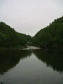
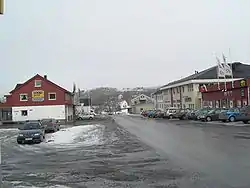 View of Evenskjer | |
 Flag 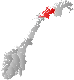 Troms within Norway | |
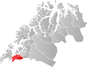 Skånland within Troms | |
| Coordinates: 68°38′24″N 16°57′26″E | |
| Country | Norway |
| County | Troms |
| District | Central Hålogaland |
| Established | 1 July 1926 |
| • Preceded by | Trondenes Municipality |
| Disestablished | 1 Jan 2020 |
| • Succeeded by | Tjeldsund Municipality |
| Administrative centre | Evenskjer |
| Area (upon dissolution) | |
| • Total | 495.00 km2 (191.12 sq mi) |
| • Land | 464.77 km2 (179.45 sq mi) |
| • Water | 30.23 km2 (11.67 sq mi) 6.1% |
| • Rank | #210 in Norway |
| Population (2018) | |
| • Total | 2,994 |
| • Rank | #265 in Norway |
| • Density | 6.4/km2 (17/sq mi) |
| • Change (10 years) | |
| Demonym | Skånlending[1] |
| Official language | |
| • Norwegian form | Bokmål |
| Time zone | UTC+01:00 (CET) |
| • Summer (DST) | UTC+02:00 (CEST) |
| ISO 3166 code | NO-1913 |
The Tjeldsund Bridge in Skånland connects the island of Hinnøya (the largest coastal island in Norway) to the Norwegian mainland.
At the time of its dissolution as a municipality on 1 January 2020, the 495-square-kilometre (191 sq mi) municipality was the 210th largest by area out of the 422 municipalities in Norway. Skånland was also the 265th most populous municipality in Norway with a population of 2,994. The municipality's population density was 6.4 inhabitants per square kilometre (17/sq mi) and its population has increased by 4.6% over the previous decade.[3][4]
General information
Skånland was established on 1 July 1926 when the large municipality of Trondenes was divided into three municipalities: Sandtorg (population: 4,224) in the southwest, Skånland (population: 2,443) in the southeast, and Trondenes (population: 3,429) in the north. During the 1960s, there were many municipal mergers across Norway due to the work of the Schei Committee. On 1 January 1964, the neighboring municipality of Astafjord (population: 1,120) was merged into Skånland. On the same date, the part of Skånland on the island of Rolla (population: 143) was transferred to neighboring Ibestad Municipality.[5]
On 1 January 2020, the neighboring municipalities of Skånland and Tjeldsund merged to form a new, larger Tjeldsund Municipality.[6][7]
Name
The municipality (originally the parish) is named after the old Skånland farm (Old Norse: Skánøyjarland) since this was where the first Skånland Church was built in 1870. The first element is the genitive case of an old name for the area (Skánøy). The meaning of this name is uncertain, but it may be of Sami origin, meaning "small mountains" (skánit). The last element is land which means "land" or "farm".[8]
Coat of arms
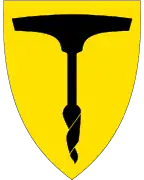
The coat of arms was granted on 19 August 1988 and it was used until 1 January 2020 when the municipality was dissolved. The official blazon is "Or an auger drill sable" (Norwegian: I gull en svart navar). This means the arms have a field (background) with a tincture of Or which means it is commonly colored yellow, but if it is made out of metal, then gold is used. The charge is an auger with a tincture of sable. The auger was chosen for the design in order to represent boat building, an industry with long roots in the municipality. The arms were designed by Arvid Sveen.[9][10][11]
Churches
The Church of Norway had three parishes (sokn) within the municipality of Skånland. It was part of the Trondenes prosti (deanery) in the Diocese of Nord-Hålogaland.
| Parish (sokn) | Church name | Location of the church | Year built |
|---|---|---|---|
| Astafjord | Astafjord Church | Grov | 1978 |
| Skånland | Skånland Church | Evenskjer | 1901 |
| Tovik | Tovik Church | Tovik | 1905 |
Economy
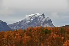
Agriculture was important in Skånland. There were also many people who worked in Harstad or at the nearby Harstad/Narvik Airport, Evenes.
Geography
The municipality included the western and northern part of the Ofoten peninsula, which is bordered by Ofotfjord in the south, Tjeldsundet in the west, and the Astafjorden and Vågsfjorden in the north. Neighbouring municipalities were Evenes to the south, Narvik in the southeast, Tjeldsund to the southwest (all three were in Nordland county). Harstad in the northwest (across the Tjeldsundet) and Gratangen in the northeast were located in Troms county. Evenskjer, located in the lowland bordering the Tjeldsundet strait, was the largest village. In the northern part of Skånland was the smaller village of Grov. Other villages were Renså, Tovik and Sandstrand.
The largest lake was Skoddebergvatnet, and the highest mountain was Skittendalstinden at 1,306 metres (4,285 ft) in the mountainous center of the peninsula. There were calcareous pine forests near Skoddebergvatnet. The lake Niingsvatnet was located on the border with Evenes.
Climate
| Climate data for Evenskjer 1961-1990 | |||||||||||||
|---|---|---|---|---|---|---|---|---|---|---|---|---|---|
| Month | Jan | Feb | Mar | Apr | May | Jun | Jul | Aug | Sep | Oct | Nov | Dec | Year |
| Average high °C (°F) | −1.1 (30.0) |
−0.9 (30.4) |
0.9 (33.6) |
4.2 (39.6) |
9.6 (49.3) |
13.4 (56.1) |
15.9 (60.6) |
15.0 (59.0) |
10.8 (51.4) |
6.2 (43.2) |
2.2 (36.0) |
0.2 (32.4) |
6.4 (43.5) |
| Daily mean °C (°F) | −3.7 (25.3) |
−3.4 (25.9) |
−1.7 (28.9) |
1.6 (34.9) |
6.4 (43.5) |
10.0 (50.0) |
12.4 (54.3) |
11.9 (53.4) |
8.0 (46.4) |
4.0 (39.2) |
−0.1 (31.8) |
−2.6 (27.3) |
3.6 (38.5) |
| Average low °C (°F) | −6.8 (19.8) |
−6.5 (20.3) |
−5.0 (23.0) |
−1.6 (29.1) |
2.7 (36.9) |
6.8 (44.2) |
9.2 (48.6) |
8.4 (47.1) |
4.8 (40.6) |
1.1 (34.0) |
−2.9 (26.8) |
−5.3 (22.5) |
0.4 (32.7) |
| Average precipitation mm (inches) | 77 (3.0) |
69 (2.7) |
57 (2.2) |
46 (1.8) |
39 (1.5) |
42 (1.7) |
64 (2.5) |
67 (2.6) |
74 (2.9) |
103 (4.1) |
77 (3.0) |
85 (3.3) |
800 (31.5) |
| Average precipitation days (≥ 1 mm) | 13.9 | 13.8 | 12.6 | 10.2 | 8.4 | 11.0 | 13.6 | 13.5 | 15.2 | 15.8 | 13.8 | 15.0 | 156.8 |
| Source: Norwegian Meteorological Institute[12] | |||||||||||||
Government
While it existed, this municipality was responsible for primary education (through 10th grade), outpatient health services, senior citizen services, unemployment, social services, zoning, economic development, and municipal roads. During its existence, this municipality was governed by a municipal council of directly elected representatives. The mayor was indirectly elected by a vote of the municipal council.[13] The municipality fell under the Trondenes District Court and the Hålogaland Court of Appeal.
Municipal council
The municipal council (Kommunestyre) of Skånland was made up of 15 representatives that were elected to four year terms. The party breakdown of the final municipal council was as follows:
| Party Name (in Norwegian) | Number of representatives | |
|---|---|---|
| Labour Party (Arbeiderpartiet) | 6 | |
| Conservative Party (Høyre) | 6 | |
| Red Party (Rødt) | 1 | |
| Socialist Left Party (Sosialistisk Venstreparti) | 1 | |
| Liberal Party (Venstre) | 1 | |
| Total number of members: | 15 | |
| Party Name (in Norwegian) | Number of representatives | |
|---|---|---|
| Labour Party (Arbeiderpartiet) | 6 | |
| Conservative Party (Høyre) | 6 | |
| Red Party (Rødt) | 1 | |
| Liberal Party (Venstre) | 2 | |
| Total number of members: | 15 | |
| Party Name (in Norwegian) | Number of representatives | |
|---|---|---|
| Labour Party (Arbeiderpartiet) | 6 | |
| Conservative Party (Høyre) | 5 | |
| Christian Democratic Party (Kristelig Folkeparti) | 1 | |
| Centre Party (Senterpartiet) | 1 | |
| Socialist Left Party (Sosialistisk Venstreparti) | 1 | |
| Liberal Party (Venstre) | 1 | |
| Total number of members: | 15 | |
| Party Name (in Norwegian) | Number of representatives | |
|---|---|---|
| Labour Party (Arbeiderpartiet) | 6 | |
| Progress Party (Fremskrittspartiet) | 1 | |
| Conservative Party (Høyre) | 4 | |
| Christian Democratic Party (Kristelig Folkeparti) | 1 | |
| Centre Party (Senterpartiet) | 1 | |
| Socialist Left Party (Sosialistisk Venstreparti) | 2 | |
| Total number of members: | 15 | |
| Party Name (in Norwegian) | Number of representatives | |
|---|---|---|
| Labour Party (Arbeiderpartiet) | 7 | |
| Conservative Party (Høyre) | 5 | |
| Christian Democratic Party (Kristelig Folkeparti) | 1 | |
| Centre Party (Senterpartiet) | 5 | |
| Socialist Left Party (Sosialistisk Venstreparti) | 2 | |
| Liberal Party (Venstre) | 1 | |
| Total number of members: | 21 | |
| Party Name (in Norwegian) | Number of representatives | |
|---|---|---|
| Labour Party (Arbeiderpartiet) | 10 | |
| Conservative Party (Høyre) | 7 | |
| Christian Democratic Party (Kristelig Folkeparti) | 1 | |
| Centre Party (Senterpartiet) | 3 | |
| Socialist Left Party (Sosialistisk Venstreparti) | 1 | |
| Liberal Party (Venstre) | 1 | |
| Indre Grovfjord Common List (Indre Grovfjord Fellesliste) | 1 | |
| Lavangseidet Common List (Lavangseidet Fellesliste) | 2 | |
| Common List Kvitnes-Nordland border (Felleslisten Kvitnes-Nordland Grense) | 3 | |
| Total number of members: | 29 | |
| Party Name (in Norwegian) | Number of representatives | |
|---|---|---|
| Labour Party (Arbeiderpartiet) | 10 | |
| Conservative Party (Høyre) | 5 | |
| Christian Democratic Party (Kristelig Folkeparti) | 1 | |
| Socialist Left Party (Sosialistisk Venstreparti) | 2 | |
| Liberal Party (Venstre) | 1 | |
| Indre Grovfjord Common List (Indre Grovfjord Fellesliste) | 1 | |
| Lavangseidet Common List (Lavangseidet Fellesliste) | 3 | |
| Common List Kvitnes-Nordland border (Felleslisten Kvitnes-Nordland Grense) | 6 | |
| Total number of members: | 29 | |
| Party Name (in Norwegian) | Number of representatives | |
|---|---|---|
| Labour Party (Arbeiderpartiet) | 12 | |
| Conservative Party (Høyre) | 6 | |
| Socialist Left Party (Sosialistisk Venstreparti) | 1 | |
| Liberal Party (Venstre) | 1 | |
| Common List Kvitnes-Nordland (Fellesliste Kvitnes-Nordland) | 5 | |
| Lavangseidet Common List (Lavangseidet fellesliste) | 4 | |
| Total number of members: | 29 | |
| Party Name (in Norwegian) | Number of representatives | |
|---|---|---|
| Labour Party (Arbeiderpartiet) | 14 | |
| Conservative Party (Høyre) | 7 | |
| Christian Democratic Party (Kristelig Folkeparti) | 2 | |
| Centre Party (Senterpartiet) | 1 | |
| Socialist Left Party (Sosialistisk Venstreparti) | 1 | |
| Liberal Party (Venstre) | 1 | |
| Lavangseidet's Common List (Lavangseidets fellesliste) | 3 | |
| Total number of members: | 29 | |
| Party Name (in Norwegian) | Number of representatives | |
|---|---|---|
| Labour Party (Arbeiderpartiet) | 11 | |
| Socialist Left Party (Sosialistisk Venstreparti) | 1 | |
| Liberal Party (Venstre) | 3 | |
| Joint list of the Conservative Party (Høyre), Christian Democratic Party (Kristelig Folkeparti), and Centre Party (Senterpartiet) | 10 | |
| Lavangseidet's Common List (Lavangseidets fellesliste) | 4 | |
| Total number of members: | 29 | |
| Party Name (in Norwegian) | Number of representatives | |
|---|---|---|
| Labour Party (Arbeiderpartiet) | 12 | |
| Christian Democratic Party (Kristelig Folkeparti) | 2 | |
| Joint List(s) of Non-Socialist Parties (Borgerlige Felleslister) | 7 | |
| Grovfjord Non-party Common List (Grovfjord Upolitiske Fellesliste) | 6 | |
| Lavangseidet Common List (Lavangseidet Fellesliste) | 2 | |
| Total number of members: | 29 | |
| Party Name (in Norwegian) | Number of representatives | |
|---|---|---|
| Local List(s) (Lokale lister) | 29 | |
| Total number of members: | 29 | |
| Party Name (in Norwegian) | Number of representatives | |
|---|---|---|
| Local List(s) (Lokale lister) | 29 | |
| Total number of members: | 29 | |
| Party Name (in Norwegian) | Number of representatives | |
|---|---|---|
| Local List(s) (Lokale lister) | 29 | |
| Total number of members: | 29 | |
| Party Name (in Norwegian) | Number of representatives | |
|---|---|---|
| Labour Party (Arbeiderpartiet) | 3 | |
| List of workers, fishermen, and small farmholders (Arbeidere, fiskere, småbrukere liste) | 1 | |
| Joint List(s) of Non-Socialist Parties (Borgerlige Felleslister) | 3 | |
| Local List(s) (Lokale lister) | 12 | |
| Total number of members: | 19 | |
| Party Name (in Norwegian) | Number of representatives | |
|---|---|---|
| Labour Party (Arbeiderpartiet) | 4 | |
| Joint List(s) of Non-Socialist Parties (Borgerlige Felleslister) | 2 | |
| Local List(s) (Lokale lister) | 13 | |
| Total number of members: | 19 | |
| Party Name (in Norwegian) | Number of representatives | |
|---|---|---|
| Labour Party (Arbeiderpartiet) | 2 | |
| Local List(s) (Lokale lister) | 14 | |
| Total number of members: | 16 | |
| Party Name (in Norwegian) | Number of representatives | |
|---|---|---|
| Labour Party (Arbeiderpartiet) | 3 | |
| List of workers, fishermen, and small farmholders (Arbeidere, fiskere, småbrukere liste) | 1 | |
| Joint List(s) of Non-Socialist Parties (Borgerlige Felleslister) | 5 | |
| Local List(s) (Lokale lister) | 7 | |
| Total number of members: | 16 | |
| Party Name (in Norwegian) | Number of representatives | |
|---|---|---|
| Labour Party (Arbeiderpartiet) | 9 | |
| Joint List(s) of Non-Socialist Parties (Borgerlige Felleslister) | 2 | |
| Local List(s) (Lokale lister) | 5 | |
| Total number of members: | 16 | |
| Party Name (in Norwegian) | Number of representatives | |
|---|---|---|
| Labour Party (Arbeiderpartiet) | 10 | |
| Joint List(s) of Non-Socialist Parties (Borgerlige Felleslister) | 3 | |
| Local List(s) (Lokale lister) | 3 | |
| Total number of members: | 16 | |
| Note: Due to the German occupation of Norway during World War II, no elections were held for new municipal councils until after the war ended in 1945. | ||
Mayors
- 1926-1945: Albert Isaksen
- 1945-1945: Tonning Larsen
- 1946-1947: Robert Mathisen
- 1948-1958: Martin Svendsen
- 1958-1959: Sigvart Isaksen
- 1960-1963: Herleif Grøneng
- 1964-1967: Peder Ellefsen
- 1968-1975: Herleif Grøneng
- 1976-1979: Aage Olsen
- 1980-1991: Odd Nilssen (Ap)
- 1992-1997: Håkon Walter Brox (H)
- 1997-2002: Terje Fjordbakk (Sp)
- 2002-2011: Svein Berg (Ap)
- 2011–2015: Einar Aune (H)
- 2015–2019: Helene Berg Nilsen (Ap)
References
- "Navn på steder og personer: Innbyggjarnamn" (in Norwegian). Språkrådet.
- "Forskrift om målvedtak i kommunar og fylkeskommunar" (in Norwegian). Lovdata.no.
- Statistisk sentralbyrå (2018). "Table: 06913: Population 1 January and population changes during the calendar year (M)" (in Norwegian). Retrieved 10 December 2018.
- Statistisk sentralbyrå. "09280: Area of land and fresh water (km²) (M)" (in Norwegian). Retrieved 10 December 2018.
- Jukvam, Dag (1999). Historisk oversikt over endringer i kommune- og fylkesinndelingen (PDF) (in Norwegian). Statistisk sentralbyrå. ISBN 9788253746845.
- "Kommunereform" (in Norwegian). Skånland kommune. Retrieved 9 September 2017.
- Jensen, Morten (6 March 2017). "Tjeldsund + Skånland = Sant" (in Norwegian). Retrieved 9 September 2017.
- Rygh, Oluf (1911). Norske gaardnavne: Tromsø amt (in Norwegian) (17 ed.). Kristiania, Norge: W. C. Fabritius & sønners bogtrikkeri. p. 14.
- "Civic heraldry of Norway - Norske Kommunevåpen". Heraldry of the World. Retrieved 28 January 2023.
- "Skånland, Troms (Norway)". Flags of the World. Retrieved 28 January 2023.
- "Godkjenning av våpen og flagg". Lovdata.no (in Norwegian). Norges kommunal- og arbeidsdepartementet. 19 August 1988. Retrieved 28 January 2023.
- "eKlima Web Portal". Norwegian Meteorological Institute. Archived from the original on 14 June 2004.
- Hansen, Tore; Vabo, Signy Irene, eds. (20 September 2022). "kommunestyre". Store norske leksikon (in Norwegian). Kunnskapsforlaget. Retrieved 1 January 2023.
- "Table: 04813: Members of the local councils, by party/electoral list at the Municipal Council election (M)" (in Norwegian). Statistics Norway.
- "Tall for Norge: Kommunestyrevalg 2011 - Troms Romsa". Valg Direktoratet. Retrieved 26 October 2019.
- "Kommunestyrevalget 1995" (PDF) (in Norwegian). Oslo-Kongsvinger: Statistisk sentralbyrå. 1996. Retrieved 18 March 2020.
- "Kommunestyrevalget 1991" (PDF) (in Norwegian). Oslo-Kongsvinger: Statistisk sentralbyrå. 1993. Retrieved 18 March 2020.
- "Kommunestyrevalget 1987" (PDF) (in Norwegian). Oslo-Kongsvinger: Statistisk sentralbyrå. 1988. Retrieved 18 March 2020.
- "Kommunestyrevalget 1983" (PDF) (in Norwegian). Oslo-Kongsvinger: Statistisk sentralbyrå. 1984. Retrieved 18 March 2020.
- "Kommunestyrevalget 1979" (PDF) (in Norwegian). Oslo: Statistisk sentralbyrå. 1979. Retrieved 18 March 2020.
- "Kommunevalgene 1975" (PDF) (in Norwegian). Oslo: Statistisk sentralbyrå. 1977. Retrieved 18 March 2020.
- "Kommunevalgene 1972" (PDF) (in Norwegian). Oslo: Statistisk sentralbyrå. 1973. Retrieved 18 March 2020.
- "Kommunevalgene 1967" (PDF) (in Norwegian). Oslo: Statistisk sentralbyrå. 1967. Retrieved 18 March 2020.
- "Kommunevalgene 1963" (PDF) (in Norwegian). Oslo: Statistisk sentralbyrå. 1964. Retrieved 18 March 2020.
- "Kommunevalgene og Ordførervalgene 1959" (PDF) (in Norwegian). Oslo: Statistisk sentralbyrå. 1960. Retrieved 18 March 2020.
- "Kommunevalgene og Ordførervalgene 1955" (PDF) (in Norwegian). Oslo: Statistisk sentralbyrå. 1957. Retrieved 18 March 2020.
- "Kommunevalgene og Ordførervalgene 1951" (PDF) (in Norwegian). Oslo: Statistisk sentralbyrå. 1952. Retrieved 18 March 2020.
- "Kommunevalgene og Ordførervalgene 1947" (PDF) (in Norwegian). Oslo: Statistisk sentralbyrå. 1948. Retrieved 18 March 2020.
- "Kommunevalgene og Ordførervalgene 1945" (PDF) (in Norwegian). Oslo: Statistisk sentralbyrå. 1947. Retrieved 18 March 2020.
- "Kommunevalgene og Ordførervalgene 1937" (PDF) (in Norwegian). Oslo: Statistisk sentralbyrå. 1938. Retrieved 18 March 2020.
- "Ordførere i Skånland". evenskjer.net (in Norwegian). Retrieved 26 February 2023.
External links
- Municipal fact sheet from Statistics Norway (in Norwegian)
 Media related to Skånland at Wikimedia Commons
 The dictionary definition of skånland at Wiktionary
 Troms travel guide from Wikivoyage
