Coyote Creek Trail
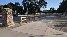
The Coyote Creek Trail is a pedestrian and cycling trail along Coyote Creek in San Jose, California, which continues into Coyote Valley and northern Morgan Hill. The Coyote Creek Trail was designated part of the National Recreation Trail system in 2009.[1] It is also part of the Bay Area Ridge Trail system.[2]
| Coyote Creek Trail | |
|---|---|
 Coyote Creek Trail near Bailey at sunset | |
| Length | 18.7 miles (30.1 km)[1] |
| Location | Santa Clara County, California |
| Designation | National Recreation Trail |
| Surface | paved |
Coyote Creek Trail in San Jose
Bay Area Ridge Trail | |||||||||||||||||||||||||||||||||||||||||||||||||||||||||||||||||||||||||||||||||||||||||||||||||||||||||||||||||||||||||||||||||||||||||||||||||||||||||||||||||||||||||||||||||||||||||||||||||||||||||||||||||||||||||||||||||||||||||||||||||||||||||||||||||||||||||||||||||||||||||||||||||||||||||||||||||||||||||||||||||||||||||||||||||||||||||||||||||||||||||||||||||||||||||||||||||||||||||||||||||||||||||||||||||||||||||
|---|---|---|---|---|---|---|---|---|---|---|---|---|---|---|---|---|---|---|---|---|---|---|---|---|---|---|---|---|---|---|---|---|---|---|---|---|---|---|---|---|---|---|---|---|---|---|---|---|---|---|---|---|---|---|---|---|---|---|---|---|---|---|---|---|---|---|---|---|---|---|---|---|---|---|---|---|---|---|---|---|---|---|---|---|---|---|---|---|---|---|---|---|---|---|---|---|---|---|---|---|---|---|---|---|---|---|---|---|---|---|---|---|---|---|---|---|---|---|---|---|---|---|---|---|---|---|---|---|---|---|---|---|---|---|---|---|---|---|---|---|---|---|---|---|---|---|---|---|---|---|---|---|---|---|---|---|---|---|---|---|---|---|---|---|---|---|---|---|---|---|---|---|---|---|---|---|---|---|---|---|---|---|---|---|---|---|---|---|---|---|---|---|---|---|---|---|---|---|---|---|---|---|---|---|---|---|---|---|---|---|---|---|---|---|---|---|---|---|---|---|---|---|---|---|---|---|---|---|---|---|---|---|---|---|---|---|---|---|---|---|---|---|---|---|---|---|---|---|---|---|---|---|---|---|---|---|---|---|---|---|---|---|---|---|---|---|---|---|---|---|---|---|---|---|---|---|---|---|---|---|---|---|---|---|---|---|---|---|---|---|---|---|---|---|---|---|---|---|---|---|---|---|---|---|---|---|---|---|---|---|---|---|---|---|---|---|---|---|---|---|---|---|---|---|---|---|---|---|---|---|---|---|---|---|---|---|---|---|---|---|---|---|---|---|---|---|---|---|---|---|---|---|---|---|---|---|---|---|---|---|---|---|---|---|---|---|---|---|---|---|---|---|---|---|---|---|---|---|---|---|---|---|---|---|---|---|---|---|---|---|---|---|---|---|---|---|---|---|---|---|---|---|---|---|---|---|---|---|---|---|---|---|---|---|---|---|---|---|---|---|---|---|---|---|---|
| |||||||||||||||||||||||||||||||||||||||||||||||||||||||||||||||||||||||||||||||||||||||||||||||||||||||||||||||||||||||||||||||||||||||||||||||||||||||||||||||||||||||||||||||||||||||||||||||||||||||||||||||||||||||||||||||||||||||||||||||||||||||||||||||||||||||||||||||||||||||||||||||||||||||||||||||||||||||||||||||||||||||||||||||||||||||||||||||||||||||||||||||||||||||||||||||||||||||||||||||||||||||||||||||||||||||||
| |||||||||||||||||||||||||||||||||||||||||||||||||||||||||||||||||||||||||||||||||||||||||||||||||||||||||||||||||||||||||||||||||||||||||||||||||||||||||||||||||||||||||||||||||||||||||||||||||||||||||||||||||||||||||||||||||||||||||||||||||||||||||||||||||||||||||||||||||||||||||||||||||||||||||||||||||||||||||||||||||||||||||||||||||||||||||||||||||||||||||||||||||||||||||||||||||||||||||||||||||||||||||||||||||||||||||
The northern portion of the trail is in the San Jose city limits. The northernmost point is at the southern tip of San Francisco Bay. The trail is not yet continuous within San Jose. A paved section exists between the Highway 237 Bikeway and Tasman Drive. A short disconnected segment is at Berryessa Road at the San Jose Flea Market and Berryessa BART Station. The trail is paved from Tully Road south for 2 miles to the end of the city-maintained segment at Hellyer County Park, where the paved county section continues.[3]
Ecological artist Deborah Kennedy was commissioned by the San Jose Public Art Program to work alongside sculptor Diana Pumpelly Bates in 2004 on completion of a community project for the Coyote Creek Trail.[4] Their public artworks, including Kennedy's 'Ripple Effect' and Bates 'Run River Run', are used to promote public awareness of a concrete landing pad and ramp leading to a levee where strollers, wheelchairs, and bicyclists have greater accessibility to the site.[4]
Coyote Creek Parkway
The southern county-maintained portion of the Coyote Creek Trail is part of the Coyote Creek Parkway, which includes the trail and a chain of county parks along the creek. The county portion is 15 miles of paved trail from Hellyer Park to Anderson Lake.[5]
Landmarks on the trail
- City of San Jose
- North San Jose segment (1.0 mile (1.6 km))
- Highway 237 Bikeway
- VTA light rail Cisco Way station
- Berryessa District segment (.25 miles (0.40 km))
- South San Jose segment (2.5 miles (4.0 km)) - contiguous with county portion of trail
- connects to Hellyer County Park
- North San Jose segment (1.0 mile (1.6 km))
- Santa Clara County (15 miles (24 km))
Gallery
 Tully Road trailhead of the Coyote Creek Trail in San Jose
 Coyote Creek Trail at Coyote Creek Lake
 Bridge over Coyote Creek on the Coyote Creek Trail
 Coyote Creek Trail crosses the creek near Bailey Avenue
References
- "Coyote Creek Trail". American Trails. Retrieved June 14, 2019.
- "South Bay Trail Maps". Bay Area Ridge Trail. Retrieved June 17, 2019.
- "Coyote Creek". City of San Jose. Retrieved June 13, 2019.
- "Ripple Effect and Run River Run; Artists: Deborah Kennedy and Diana Pumpelly Bates". City of San Jose Public Art Program. April 2004. Retrieved August 2, 2019.
- "Coyote Creek Parkway". Santa Clara County. Retrieved June 13, 2019.
External links
- "Coyote Creek Trail-San Jose Trail Network", by American Trails
- Coyote Creek Parkway North trail map by Bay Area Ridge Trail
- Coyote Creek Parkway South trail map by Bay Area Ridge Trail
- "Coyote Creek Trail", by Bay Area Mountain Bike Rides
- Coyote Creek Trail North: Yerba Buena Road to San Francisco Bay by Ronald Horii, observations in 2009
- Coyote Creek Trail South: Hellyer Park to Anderson Lake Park by Ronald Horii, observations in 2009

