Crestline, Kansas
Crestline is an unincorporated community in Cherokee County, Kansas, United States.[1] As of the 2020 census, the population of the community and nearby areas was 116.[2] Crestline is located on U.S. Route 400 7.5 miles (12.1 km) east of Columbus. Crestline has a post office with ZIP code 66728.[3]
Crestline, Kansas | |
|---|---|
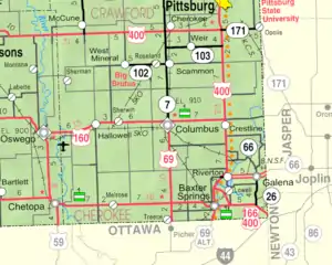 KDOT map of Cherokee County (legend) | |
 Crestline  Crestline | |
| Coordinates: 37°10′12″N 94°42′23″W[1] | |
| Country | United States |
| State | Kansas |
| County | Cherokee |
| Elevation | 869 ft (265 m) |
| Population | |
| • Total | 116 |
| Time zone | UTC-6 (CST) |
| • Summer (DST) | UTC-5 (CDT) |
| ZIP code | 66728 |
| Area code | 620 |
| FIPS code | 20-16325 |
| GNIS ID | 2806469[1] |
History
Crestline was a station on the St. Louis–San Francisco Railway.[4]
Demographics
| Census | Pop. | Note | %± |
|---|---|---|---|
| 2020 | 116 | — | |
| U.S. Decennial Census | |||
For statistical purposes, the United States Census Bureau has defined Crestline as a census-designated place (CDP).
References
- U.S. Geological Survey Geographic Names Information System: Crestline, Kansas
- "Profile of Crestline, Kansas (CDP) in 2020". United States Census Bureau. Archived from the original on November 9, 2022. Retrieved November 9, 2022.
- "Free ZIP Code Lookup with area code, county, geocode, MSA/PMSA, population". www.zipinfo.com. Archived from the original on August 21, 2016. Retrieved September 16, 2016.
- Blackmar, Frank Wilson (1912). Kansas: A Cyclopedia of State History, Embracing Events, Institutions, Industries, Counties, Cities, Towns, Prominent Persons, Etc. Standard Publishing Company. pp. 484.
Further reading
External links
Municipalities and communities of Cherokee County, Kansas, United States | ||
|---|---|---|
| Cities | 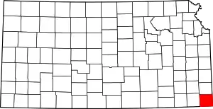 Map of Kansas highlighting Cherokee County | |
| Unincorporated communities | ||
| Ghost towns | ||
| Townships | ||
| Footnotes | †This community is designated a Census-Designated Place (CDP) by the United States Census Bureau. ‡This community also has portions in an adjacent county or counties. | |
This article is issued from Wikipedia. The text is licensed under Creative Commons - Attribution - Sharealike. Additional terms may apply for the media files.