Lowell, Kansas
Lowell is an unincorporated community in Cherokee County, Kansas, United States.[1] As of the 2020 census, the population of the community and nearby areas was 244.[2]
Lowell, Kansas | |
|---|---|
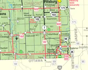 KDOT map of Cherokee County (legend) | |
 Lowell  Lowell | |
| Coordinates: 37°03′03″N 94°42′11″W[1] | |
| Country | United States |
| State | Kansas |
| County | Cherokee |
| Elevation | 827 ft (252 m) |
| Population | |
| • Total | 244 |
| Time zone | UTC-6 (CST) |
| • Summer (DST) | UTC-5 (CDT) |
| ZIP code | 66713, 66739 |
| Area code | 620 |
| FIPS code | 20-43050 |
| GNIS ID | 2630053[1] |
History
A post office was opened in Lowell in 1868, and remained in operation until it was discontinued in 1905.[3]
Geography
Lowell is located in southeastern Cherokee County near the southeastern corner of Kansas. It is bordered to the north by the Spring River, a tributary of the Neosho River. Across the river is the community of Riverton. Baxter Springs is 4 miles (6 km) by road to the southwest.
Demographics
| Census | Pop. | Note | %± |
|---|---|---|---|
| 2010 | 283 | — | |
| 2020 | 244 | −13.8% | |
| U.S. Decennial Census | |||
For statistical purposes, the United States Census Bureau has defined Lowell as a census-designated place (CDP).
References
- U.S. Geological Survey Geographic Names Information System: Lowell, Kansas
- "Profile of Lowell, Kansas (CDP) in 2020". United States Census Bureau. Archived from the original on November 9, 2022. Retrieved November 9, 2022.
- "Kansas Post Offices, 1828-1961 (archived)". Kansas Historical Society. Archived from the original on October 9, 2013. Retrieved June 6, 2014.
Further reading
External links
Municipalities and communities of Cherokee County, Kansas, United States | ||
|---|---|---|
| Cities | 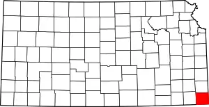 Map of Kansas highlighting Cherokee County | |
| Unincorporated communities | ||
| Ghost towns | ||
| Townships | ||
| Footnotes | †This community is designated a Census-Designated Place (CDP) by the United States Census Bureau. ‡This community also has portions in an adjacent county or counties. | |
This article is issued from Wikipedia. The text is licensed under Creative Commons - Attribution - Sharealike. Additional terms may apply for the media files.