Cyclone Ruby
Tropical Cyclone Ruby was a strong but short-lived tropical cyclone that impacted New Caledonia with strong winds and rainfall, after its predecessor tropical low and a nearby trough caused disruption over some parts of the Solomon Islands. The third named system of the 2021-22 Australian region cyclone season and the first cyclone of the 2021-22 South Pacific cyclone season, Ruby formed from an area of convection that was first monitored by the Joint Typhoon Warning Cente (JTWC) on 8 December in the Solomon Sea. However, the system didn't fully become a tropical low until 06:00 UTC on 10 December, when the Australian Bureau of Metorology (BoM) started to issue bulletins. After stalling over the area, the storm moved southeastwards over the Coral Sea, where it continued to develop under favorable conditions. The system was finally upgraded to Tropical Cyclone Ruby two days later as gale-force winds encircled its eastern portions.[1]
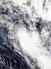
 Cyclone Ruby on 13 December | |
| Meteorological history | |
|---|---|
| Formed | 9 December 2021 |
| Extratropical | 15 December 2021 |
| Dissipated | 17 December 2021 |
| Category 2 tropical cyclone | |
| 10-minute sustained (FMS) | |
| Highest winds | 110 km/h (70 mph) |
| Lowest pressure | 975 hPa (mbar); 28.79 inHg |
| Category 1-equivalent tropical cyclone | |
| 1-minute sustained (SSHWS/JTWC) | |
| Highest winds | 130 km/h (80 mph) |
| Overall effects | |
| Fatalities | None |
| Areas affected | Solomon Islands, New Caledonia |
| IBTrACS | |
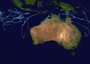
Part of the 2021–22 Australian region and South Pacific cyclone seasons | |
Wind and rainfall alerts were placed over some islands of the Solomon Islands, due to a trough and the cyclone's predecessor. Two reservoirs, the Kombito and the Kongulai River, were closed and people using the waters of the embankments were advised to boil water as the rivers were contaminated with sediments due to rainfall from the system. Later, cyclone pre-watches were issued for the whole island of New Caledonia as Ruby slowly approached the archipelago, with warnings being further upgraded to Alert Level 2. Flights, ferry and other transportation services were halted as a precaution, and potentially-affected people were evacuated. Over 2,000 residential areas lost electricity as Ruby touched down in the archipelago, with reports of trees being uprooted, in one case damaging a house.[2] Strong winds bashed the northern part of New Caledonia, while the whole portion received heavy rainfall. No deaths were confirmed.
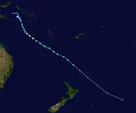
Meteorological history

Tropical storm (39–73 mph, 63–118 km/h)
Category 1 (74–95 mph, 119–153 km/h)
Category 2 (96–110 mph, 154–177 km/h)
Category 3 (111–129 mph, 178–208 km/h)
Category 4 (130–156 mph, 209–251 km/h)
Category 5 (≥157 mph, ≥252 km/h)
Unknown
By 6 December, the Australian Bureau of Meteorology was monitoring the Solomon Sea and its adjoining regions for possible tropical development.[3] The next day, the agency noted that this potential system could develop further.[4] Meanwhile, on 8 December at 06:00 UTC, the Joint Typhoon Warning Center started to track the system as "Invest 93P" while it was 225 nautical miles (417 km; 259 mi) to the west of Honiara, Solomon Islands. At that time, the agency noted weak convection winds around a large low-level circulation center. The sprawling disturbance was analysed as being located in a "marginally favorable" environment by the JTWC, citing low to moderate wind shear and conducive 30–31 °C (86–88 °F) sea surface temperatures. However, the agency only gave the system a "low" chance of developing for the following 24 hours.[5] At 00:00 UTC on the next day, the BoM reported that the system had developed into Tropical Low 07U.[1] The JTWC further upgraded the system's chances of strengthening to "medium" by 06:00 UTC of 9 December, and to "high" by 21:30 UTC with its issuance of a Tropical Cyclone Formation Alert (TCFA).[6][7] By the next day, the BoM noted that its deep convection had become more organized overnight, and reported that the system was strengthening as it continued to move southeast slowly, before adopting a more southward track under the influence of a mid-level high pressure system to its east. By 00:00 UTC on December 11, gale-force winds briefly developed in 07U's eastern quadrant, but eased three hours later. The BoM put the storm's intensity at that time at 35 kn (65 km/h; 40 mph), below tropical cyclone status.[1]
At 21:00 UTC, the JTWC upgraded the system to a tropical storm more than 767 nautical miles (1,420 km; 883 mi) to the northwest of Noumea, New Caledonia.[8] With improving satellite presentations and Dvorak estimates, the BoM upgraded 07U to a Category 1 tropical cyclone by 00:00 UTC the next day, giving it the name Ruby. Twelve hours later, Ruby intensified into a Category 2 tropical cyclone, based on scatterometer passes.[1] The JTWC then upgraded the system to a Category 1-equivalent tropical cyclone by 21:00 UTC.[9]
At 10:00 AEST (00:00 UTC) of 13 December, Ruby reached its peak intensity, according to the BoM, with maximum 10-minute winds of 60 knots (110 km/h; 69 mph),[1] before moving over the South Pacific basin.[10] At that point, the Australian Bureau of Meteorology passed the responsibility of tracking the system over to the Fiji Meteorological Service.[11]
Upon moving into the South Pacific region, westerly wind shear began to inhibit further intensification, as the influence of a trough passing to the south of Ruby increased.[1] This made the system weaken slightly, with the combination of a mid-level dry air entrainment.[12] At 17:00 UTC (04:00 NCT the next day), Ruby made landfall in Belep, New Caledonia, before moving over Poum an hour later.[13] The JTWC subsequently downgraded Ruby into a tropical storm late on the same day.[14] As the storm emerged from New Caledonia at 06:00 UTC (17:00 NCT) on 14 December,[13] the storm encountered a marginally favorable environment, with high wind shear, cool sea surface temperatures, and dry air entrainment offset by strong poleward outflow.[15] With its deep convection quickly reducing,[1] and the storm's center continuing to elongate,[16] the FMS downgraded Ruby to a Category 1 tropical cyclone 12 hours later.[17] The JTWC issued its final advisory on the storm three hours later, as the storm was already undergoing subtropical transition.[18] The FMS passed the responsibility of warning Ruby to the New Zealand MetService the next day, as it left its area of responsibility towards the south-east.[19] By 06:00 that same day, the MetService reported that Ruby had slightly restrengthened,[20] before reclassifying it as an extratropical cyclone twelve hours later.[21]
Preparations and impacts
Solomon Islands
Due to the cyclone's tropical low predecessor along with a trough active over the country, the Solomon Islands Meteorological Services issued a strong wind and heavy rain warnings for the archipelago.[22][23] Individuals living near rivers were also advised to prepare and take the necessary precautions, according to the meteorological agency.[23] Due to the downpour, several sediments contaminated the reservoirs at Kombito and Kongulai Rivers, forcing the water authority of the country to close them and them alerting people to boil their waters for their safety. The newspaper Solomon Star also noted that many children faced vomiting and diarrhea problems due to the incident.[24] By 10 December, the water reservoir at Kongulai was successfully restored.[25]
New Caledonia

Winds around 150 kilometres per hour (93 mph) and torrential rainfall were expected in New Caledonia from the storm. By 11 December, the country was placed under a cyclone pre-alert due to the brewing storm, starting at 5:00 NCST (18:00 UTC). 29 municipalities in the country were also placed under "yellow vigilance".[26][27][28] Alert Level 1 was also placed over the country's North and South Provinces and further, into Alert Level 2. Ferry services bound for the Isle of Pines, Belep and Ouaième were halted, and Air Calédonie flights for 14 December were canceled. A school building was requested to be an emergency shelter for possible evacuees in Houaïlou, while Kouaoua's town building were used. Four areas in the country's south also offered shelter. Sport areas in Nouméa and some campuses in the University of New Caledonia were closed.[29]
The first impacts from Ruby were felt at the North Province, where strong winds lashed the region.[29] Ruby was the first cyclone to make its landfall in the northern region since Cyclone Frank in 1990.[30] 678 households in Canala, Kaala-Gomen and Koumac lost electricity due to Ruby, and power outages disrupted some reservoirs in Voh. Over 2,569 lost power earlier in these areas. Poingam registered the highest recorded wind gust of the storm, at 185 kilometres per hour (115 mph). Touho got 138 kilometres per hour (86 mph).[13]
Trees were downed across the country, felling power lines. A public highway was impassable in Thia due to a river nearly overflowing.[2] Over a 12-hour period on 14 December, the highest rainfall on the country's west coast was 76.5 millimetres (3.01 in), the highest in the central region was 195.1 millimetres (7.68 in), and the highest on the east coast was 158.4 millimetres (6.24 in).[31] The highest rainfall was reported by a weather station at Rivière Blanche in Yaté, with 303.1 millimetres (11.93 in).[13] 14,864 households lost their power supply due to Ruby.
As the storm moved away from the country, all alerts were lifted and businesses reopened.[32]
See also
- Weather of 2021
- Tropical cyclones in 2021
- Cyclone Niran (2021)
- Cyclone Beni (2003)
References
- Matthew Boterhoven; Craig Earl-Spurr; Lauren Pattie; Nadine Birch (27 June 2022). Tropical Cyclone Ruby (PDF) (Report). Tropical Cyclone Report. Perth, Western Australia: Australian Bureau of Meteorology. Retrieved 27 July 2022.
- "[EN DIRECT] Ruby se renforce en descendant la côte Est" [[LIVE] Ruby strengthens as she travels down the East Coast]. LNC.nc | Les Nouvelles Calédoniennes, le Journal de Nouvelle Calédonie (in French). 2021-12-14. Archived from the original on 2021-12-14. Retrieved 2021-12-14.
- "Tropical Cyclone Outlook for the Coral Sea Issued at 2:40 pm EST on Monday 6 December 2021 for the period until midnight EST Thursday 9 December 2021". Australian Bureau of Meteorology. 6 December 2021. Archived from the original on 6 December 2021. Retrieved 10 December 2021.
- "Tropical Cyclone Outlook for Coral Sea Issued at 2:49 pm EST on Tuesday 7 December 2021 for the period until midnight EST Friday 10 December 2021". Australian Bureau of Meteorology. 7 December 2021. Archived from the original on 25 January 2019. Retrieved 10 December 2021.
{{cite web}}: CS1 maint: bot: original URL status unknown (link) - "Significant Tropical Weather Advisory for the Western and South Pacific Oceans 080600Z-090600Z December 2021". United States Joint Typhoon Warning Center. 8 December 2021. Archived from the original on 2 January 2021. Retrieved 10 December 2021.
- "Significant Tropical Weather Advisory for the Western and South Pacific Oceans 090600Z-100600Z December 2021". United States Joint Typhoon Warning Center. 9 December 2021. Archived from the original on 2 January 2021. Retrieved 10 December 2021.
- "Tropical Cyclone Formation Alert (Invest 93P)". United States Joint Typhoon Warning Center. 9 December 2021. Archived from the original on 10 December 2021. Alt URL
- Tropical Storm 03P (Three) Warning No. 1 (Report). United States Joint Typhoon Warning Center. 11 December 2021. Retrieved 11 December 2021. Alt URL
- Tropical Cyclone 03P (Ruby) Warning No. 5 (Report). United States Joint Typhoon Warning Center. 12 December 2021. Retrieved 12 December 2021. Alt URL
- "Updated Tropical Cyclone Outlook for Coral Sea Issued at 1:01 pm EST on Monday 13 December 2021 for the period until midnight EST Thursday 16 December 2021". Australian Bureau of Meteorology. 13 December 2021. Archived from the original on 25 January 2019. Retrieved 13 December 2021.
- "Hurricane Warning 009 for Tropical Cyclone Ruby". met.gov.fj. Fiji Meteorological Service. 12 December 2021. Archived from the original on 13 December 2021. Retrieved 13 December 2021.
- Prognostic Reasoning for Tropical Storm 03P (Ruby) Warning No. 7 (Report). United States Joint Typhoon Warning Center. 13 December 2021. Archived from the original on 2021-12-12. Retrieved 13 December 2021. Alt URL
- Bilan Métorologique du Passage de la Dépression Tropicale Forte Ruby du 13 au 14 Décembre 2021 [Metorological assessment of the passage of the Strong Tropical Depression Ruby from 13 to 14 December 2021] (Report) (in French). Météo-France Nouvelle-Calédonie. December 17, 2021. Retrieved January 16, 2023.
- Prognostic Reasoning for Tropical Cyclone 03P (Ruby) Warning No. 9 (Report). United States Joint Typhoon Warning Center. 13 December 2021. Archived from the original on 2021-12-12. Retrieved 13 December 2021. Alt URL
- Prognostic Reasoning for Tropical Cyclone 03P (Ruby) Warning No. 11 (Report). United States Joint Typhoon Warning Center. 14 December 2021. Archived from the original on 2021-12-12. Retrieved 14 December 2021. Alt URL
- Prognostic Reasoning for Tropical Cyclone 03P (Ruby) Warning No. 12 (Report). United States Joint Typhoon Warning Center. 14 December 2021. Archived from the original on 2021-12-12. Retrieved 14 December 2021. Alt URL
- "Tropical Disturbance Advisory Number A6 for Tropical Cyclone Ruby". Fiji Meteorological Service. 14 December 2021. Archived from the original on 14 December 2021. Retrieved 16 January 2023 – via MT Archive. Alt URL
- Tropical Cyclone 03P (Ruby) Warning No. 13 (Report). United States Joint Typhoon Warning Center. 14 December 2021. Archived from the original on 2021-12-12. Retrieved 14 December 2021. Alt URL
- "Gale Warning 092 for Tropical Cyclone Ruby". New Zealand Meteorological Service. 15 December 2021. Archived from the original on 15 December 2021. Retrieved 17 January 2023 – via MT Archive. Alt URL
- "Gale Warning 094 for Tropical Cyclone Ruby". New Zealand Meteorological Service. 15 December 2021. Archived from the original on 15 December 2021. Retrieved 17 January 2023 – via MT Archive. Alt URL
- "Gale Warning 100 for Low former Cyclone Ruby". New Zealand Meteorological Service. 15 December 2021. Archived from the original on 15 December 2021. Retrieved 17 January 2023 – via MT Archive. Alt URL
- "Strong Wind Warning Issued". Solomon Islands Times. 8 December 2021. Archived from the original on 8 December 2021. Retrieved 10 December 2021.
- "Warning of More Heavy Rain and Possible Flooding". Solomon Islands Times. 8 December 2021. Archived from the original on 8 December 2021. Retrieved 10 December 2021.
- John Follet (8 December 2021). "Residents' advice to boil water". Solomon Star. Archived from the original on 10 December 2021. Retrieved 10 December 2021.
{{cite news}}: CS1 maint: bot: original URL status unknown (link) - "Kongulai Water Source Restored, Kombito Remains Closed". Solomon Islands Times. 10 December 2021. Archived from the original on 10 December 2021. Retrieved 11 December 2021.
- "Météo : une dépression tropicale se rapproche petit à petit des côtes calédoniennes" [Weather forecast: a tropical depression is gradually approaching the Caledonian coast]. Nouvelle-Calédonie la 1ère (in French). 11 December 2021. Archived from the original on 11 December 2021. Retrieved 11 December 2021.
- "Météo : préalerte cyclonique annoncée pour dimanche matin" [Weather forecast: cyclonic early warning announced for Sunday morning]. Nouvelle-Calédonie la 1ère (in French). Archived from the original on 11 December 2021. Retrieved 11 December 2021.
- "Désormais nommée Ruby, la dépression tropicale passe de faible à modérée" [Now named Ruby, the tropical depression goes from low to moderate]. Nouvelle-Calédonie la 1ère (in French). Archived from the original on 12 December 2021. Retrieved 12 December 2021.
- "La Nouvelle-Calédonie se prépare à l'arrivée de la dépression Ruby" [New Caledonia braces for onset of Ruby Depression]. Nouvelle-Calédonie la 1ère (in French). Archived from the original on 2021-12-13. Retrieved 2021-12-13.
- "[ACTIVITE CYCLONIQUE] #RUBY est en phase d'atterrissage sur la pointe Nord de la Grande Terre. A peu près équivalent en intensité, le dernier cyclone ayant impacté la zone est FRANK le 19 février 1999. Les dégâts avaient été très importants : routes impraticables, coupures d'eau, d'électricité et de téléphone, dommages agricoles considérables, habitations endommagées..." [[CYCLONIC ACTIVITY] #RUBY is in the landing phase on the northern tip of Grande Terre. Roughly equivalent in intensity, the last cyclone to have impacted the area was FRANK on February 19, 1999. The damage had been very significant: impassable roads, water, electricity and telephone cuts, considerable agricultural damage, damaged houses. ..]. Météo-France Nouvelle-Calédonie (in French). Archived from the original on 14 December 2021. Retrieved 14 November 2021 – via Facebook.
- "[ACTIVITÉ CYCLONIQUE] 🌧 A l'avant du phénomène, l'activité pluvieuse de #RUBY ne faiblit pas . La côte Est est particulièrement touchée avec des cumuls avoisinant les 150 à 200 mm en 12 heures sur Houaïlou, Thio et Yaté" [[CYCLONIC ACTIVITY] 🌧 Ahead of the phenomenon, #RUBY's rainy activity does not weaken. The East Coast is particularly hit with cumulative rainfall of 150 to 200 mm in 12 hours over Houaïlou, Thio and Yaté.]. Météo-France Nouvelle-Calédonie (in French). 14 December 2021. Retrieved 14 December 2021 – via Facebook.
- "REPLAY. Ruby a quitté la Nouvelle-Calédonie, phase de sauvegarde enclenchée. Revivez le passage de la dépression tropicale" [REPLAY. Ruby a quitté la Nouvelle-Calédonie, phase de sauvegarde enclenchée. Revivez le passage de la dépression tropicale.]. Nouvelle Calédonie la 1ère (in French). Archived from the original on 2021-12-13. Retrieved 15 December 2021.
External links
- World Meteorological Organization
- Australian Bureau of Meteorology
- Fiji Meteorological Service
- New Zealand MetService
- Joint Typhoon Warning Center

