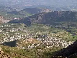
Sisakht
Sisakht (Persian: سیسخت; Northern Luri: سیسخت, SỉSext; also Romanized as Sīsakht and Sī Sakht; also known as Deh Bozorg-e Sīsakht, Deh Bozorg-e Sīsākht, and Deh-e Bozorg Sīsakht)[3] is a city in the Central District of Dana County, Kohgiluyeh and Boyer-Ahmad province, Iran, and serves as both capital of the district and of the county.
Sisakht
سیسخت | |
|---|---|
City | |
 | |
 Sisakht | |
| Coordinates: 30°51′39″N 51°27′28″E[1] | |
| Country | |
| Province | Kohgiluyeh and Boyer-Ahmad |
| County | Dana |
| District | Central |
| Population (2016)[2] | |
| • Total | 7,855 |
| Time zone | UTC+3:30 (IRST) |
Residents belong to Lur ethnic group and speak the Luri language.[4] Sisakht is on the foothills of Zagros Mountains, 34 km from Yasuj, in the northern part of the province. The area of Dana is a protected area.
At the 2006 National Census, its population was 6,342 in 1,528 households.[5] The following census in 2011 counted 7,389 people in 1,852 households.[6] The latest census in 2016 showed a population of 7,855 people in 2,200 households.[2]
History
Traces of ancient pottery have been found in excavations in Sisakht, as well as graves dating to c. 3000 BC.[7] In Telespid, registered in the Iranian national heritage Organization list, there are traces of Sassanian and Safavid eras.
Climate
The city of Sisakht has pleasant air, plentiful water and beautiful scenery due to geographical location on the slopes of Dena Mountain. Its climate is influenced by the cold Dena Mountains and is covered by snow in parts of the autumn and throughout the winter.
| Climate data for Sisakht | |||||||||||||
|---|---|---|---|---|---|---|---|---|---|---|---|---|---|
| Month | Jan | Feb | Mar | Apr | May | Jun | Jul | Aug | Sep | Oct | Nov | Dec | Year |
| Average high °C (°F) | 6.1 (43.0) |
8.9 (48.0) |
13.0 (55.4) |
17.6 (63.7) |
24.5 (76.1) |
31.1 (88.0) |
34.3 (93.7) |
33.6 (92.5) |
30.7 (87.3) |
24.3 (75.7) |
16.4 (61.5) |
9.9 (49.8) |
20.9 (69.6) |
| Average low °C (°F) | −6.7 (19.9) |
−3.9 (25.0) |
−0.8 (30.6) |
3.5 (38.3) |
7.9 (46.2) |
11.8 (53.2) |
15.7 (60.3) |
14.4 (57.9) |
10.5 (50.9) |
5.4 (41.7) |
0.8 (33.4) |
−3.1 (26.4) |
4.6 (40.3) |
| Average precipitation mm (inches) | 57 (2.2) |
45 (1.8) |
47 (1.9) |
32 (1.3) |
12 (0.5) |
1 (0.0) |
2 (0.1) |
1 (0.0) |
0 (0) |
4 (0.2) |
23 (0.9) |
47 (1.9) |
271 (10.7) |
| Source: Climate-data.org | |||||||||||||
References
- OpenStreetMap contributors (14 August 2023). "Sisakht, Dana County" (Map). OpenStreetMap. Retrieved 14 August 2023.
- "Census of the Islamic Republic of Iran, 1395 (2016)". AMAR (in Persian). The Statistical Center of Iran. p. 17. Archived from the original (Excel) on 2 November 2021. Retrieved 19 December 2022.
- Sisakht can be found at GEOnet Names Server, at this link, by opening the Advanced Search box, entering "-3060285" in the "Unique Feature Id" form, and clicking on "Search Database".
- "Statistical Centre of Iran > Population and Housing Censuses". www.amar.org.ir. Retrieved 16 April 2023.
- "Census of the Islamic Republic of Iran, 1385 (2006)". AMAR (in Persian). The Statistical Center of Iran. p. 17. Archived from the original (Excel) on 20 September 2011. Retrieved 25 September 2022.
- "Census of the Islamic Republic of Iran, 1390 (2011)" (Excel). Iran Data Portal (in Persian). The Statistical Center of Iran. p. 17. Retrieved 19 December 2022.
- "Paaychol Graveyard, Sisakht (Boyer Ahmad) 2022 Tourist Attraction in Boyer Ahmad (Yasooj), travel to iran, Visit Iran".
| Capital | 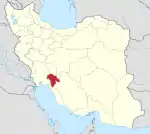 | ||||||||||||||||||
|---|---|---|---|---|---|---|---|---|---|---|---|---|---|---|---|---|---|---|---|
| Counties and cities |
| ||||||||||||||||||
| Sights |
| ||||||||||||||||||
| populated places | |||||||||||||||||||