Landeh County
Landeh County (Persian: شهرستان لنده) is in Kohgiluyeh and Boyer-Ahmad province, Iran. Its capital is the city of Landeh.[3]
Landeh County
Persian: شهرستان لنده | |
|---|---|
County | |
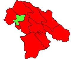 Location of Landeh County in Kohgiluyeh and Boyer-Ahmad province | |
 Location of Kohgiluyeh and Boyer-Ahmad province in Iran | |
| Coordinates: 30°58′53″N 50°21′06″E[1] | |
| Country | |
| Province | Kohgiluyeh and Boyer-Ahmad |
| Capital | Landeh |
| Districts | Central, Mugarmun |
| Population (2016)[2] | |
| • Total | 21,812 |
| Time zone | UTC+3:30 (IRST) |
At the 2006 census, the region's population (as the former Landeh District of Kohgiluyeh County) was 21,151 in 3,973 households.[4] The following census in 2011 counted 21,367 people in 4,584 households.[5] The district was separated from the county in September 2012.[3] At the 2016 census, the county's population was 21,812 in 5,560 households, by which time the district had been separated from the county to form Landeh County.[2]
Administrative divisions
The population history and structural changes of Landeh County's administrative divisions over three consecutive censuses are shown in the following table. The latest census shows two districts, four rural districts, and one city.[2]
| Administrative Divisions | 2006[4] | 2011[5] | 2016[2] |
|---|---|---|---|
| Central District2 | 21,151 | 21,367 | 18,951 |
| Olya Tayeb Rural District | 3,253 | 2,144 | 2,189 |
| Tayebi-ye Garmsiri-ye Shomali Rural District | 7,358 | 7,553 | 3,990 |
| Landeh (city) | 10,540 | 11,670 | 12,772 |
| Mugarmun District | 2,861 | ||
| Shitab Rural District | 1,997 | ||
| Vahdat Rural District | 864 | ||
| Total | 21,151 | 21,367 | 21,812 |
| 1As a part of Kohgiluyeh County at the 2006 and 2011 censuses 2Figures for 2006 and 2011 are for the former Landeh District of Kohgiluyeh County | |||
References
- OpenStreetMap contributors (15 August 2023). "Landeh County" (Map). OpenStreetMap. Retrieved 15 August 2023.
- "Census of the Islamic Republic of Iran, 1395 (2016)". AMAR (in Persian). The Statistical Center of Iran. p. 17. Archived from the original (Excel) on 2 November 2021. Retrieved 19 December 2022.
- Rahimi, Mohammadreza (29 September 2013). "Carrying out country divisions in Kohgiluyeh and Boyer-Ahmad province". Qavanin (in Persian). Ministry of Interior. Archived from the original on 14 August 2023. Retrieved 14 August 2023.
- "Census of the Islamic Republic of Iran, 1385 (2006)". AMAR (in Persian). The Statistical Center of Iran. p. 17. Archived from the original (Excel) on 20 September 2011. Retrieved 25 September 2022.
- "Census of the Islamic Republic of Iran, 1390 (2011)" (Excel). Iran Data Portal (in Persian). The Statistical Center of Iran. p. 17. Retrieved 19 December 2022.
| Capital | 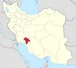 | ||||||||||||||||||
|---|---|---|---|---|---|---|---|---|---|---|---|---|---|---|---|---|---|---|---|
| Counties and cities |
| ||||||||||||||||||
| Sights |
| ||||||||||||||||||
| populated places | |||||||||||||||||||