Dingalan
Dingalan, officially the Municipality of Dingalan, Municipal District of Dingalan (Tagalog: Bayan ng Dingalan; Ilocano: Ili ti Dingalan), is a 3rd-class municipality in the province of Aurora, Philippines. According to the 2020 census, it has a population of 27,878 people.[3]
Dingalan | |
|---|---|
| Municipality of Dingalan, Municipal District of Dingalan | |
Municipal government grounds | |
 Flag | |
| Nickname: Gateway to Southern Tagalog | |
| Motto(s): Positibo, Agresibo, Progresibong Pagbabago | |
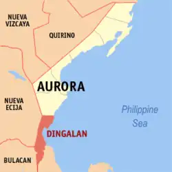
 Map of Aurora with Dingalan highlighted | |
OpenStreetMap | |
.svg.png.webp) Dingalan Location within the Philippines | |
| Coordinates: 15°23′N 121°24′E | |
| Country | Philippines |
| Region | Central Luzon |
| Province | Aurora |
| District | Lone district |
| Founded | 1962 |
| Barangays | 11 (see Barangays) |
| Government | |
| • Type | Sangguniang Bayan |
| • Mayor | Shierwin H. Taay |
| • Vice Mayor | Edgardo R. Galvez |
| • Representative | Rommel Rico T. Angara |
| • Municipal Council | Members |
| • Electorate | 19,055 voters (2022) |
| Area | |
| • Total | 304.55 km2 (117.59 sq mi) |
| Elevation | 272 m (892 ft) |
| Highest elevation | 1,367 m (4,485 ft) |
| Lowest elevation | 0 m (0 ft) |
| Population (2020 census)[3] | |
| • Total | 27,878 |
| • Density | 92/km2 (240/sq mi) |
| • Households | 6,854 |
| Economy | |
| • Income class | 3rd municipal income class |
| • Poverty incidence | 12.73 |
| • Revenue | ₱ 150.9 million (2020) |
| • Assets | ₱ 310.6 million (2020) |
| • Expenditure | ₱ 144 million (2020) |
| • Liabilities | ₱ 70.75 million (2020) |
| Service provider | |
| • Electricity | Aurora Electric Cooperative (AURELCO) |
| Time zone | UTC+8 (PST) |
| ZIP code | 3207 |
| PSGC | |
| IDD : area code | +63 (0)42 |
| Native languages | Umiray Dumaget Tagalog Ilocano |
| Website | www |
Dingalan has several caves, of which the Lamao Caves are the best known. The rough shoreline and very high waves of Dingalan make it attractive to surfers.
History
Dingalan, formerly just a barangay, was created a municipal district within the municipality of Baler in 1956.[5] It was declared a town in 1962.[6]
The name Dingalan is a Dumagat word for "by the Galan River", used because the territory crosses 15 rivers and streams. The river itself is named after the Spanish priest Bartolome Galan, who arrived in Quezon during the Spanish colonial era.
In the early 1900s, settlers from Quezon, Nueva Ecija, and the Ilocos, along with Bicolanos and Kapampangans (Pampangos), started to migrate to Dingalan. They were generally lowland cultivators in search of arable land. Internal migration heightened in the 1930s when Don Felipe Buencamino started his logging and sawmill operations. Soon after, intermarriages among Tagalogs, Ilocanos, Pampangos, and Bicolanos enriched the cultural diversity of the settlers.[7]
From November 30 to December 3, 2004, the town was wiped out by the tropical storms Violeta, Winnie, and Yoyong. The town benefited from the relief efforts of foreign traders, some Christian groups, La Salle Greenhills, and the Philippine National Red Cross.
Since the 1990s, due to its distance from Aurora's capital Baler, Dingalan has been pushing to be included in Nueva Ecija. Services from Palayan City, the capital of Nueva Ecija, is closer. Currently, there are no roads that directly connect Dingalan to Baler.
Geography
According to the Philippine Statistics Authority, the municipality has a land area of 304.55 square kilometres (117.59 sq mi), [8] constituting 9.68% of the 3,147.32-square-kilometre- (1,215.19 sq mi) total area of Aurora.
Dingalan is situated approximately 183 kilometres (114 mi) north-east of Manila. It is bounded on the north by San Luis, west by Gabaldon and General Tinio (Nueva Ecija) and Doña Remedios Trinidad (Bulacan), south by General Nakar (Quezon), and east by the Benham Rise or Plateau and Philippine Sea.
It is a small town with one main cemented road with branching alleys. Further south of the town proper are the barangays of Aplaya, Butas na Bato, Matawe, Ibona, Dikapanikian and Umiray. The premier barangay north of the town is Paltic. All of the barangays are located on the seashore, except for Poblacion and two barangays located in the mountains. The whole town is mountainous due to the Sierra Madre. The Umiray River separates the town from Quezon Province.
The National Government has an ongoing move to transfer Municipality of Dingalan to become part of Nueva Ecija Province for the reason that the said municipality is geographically and strategically within the said Province. This was favored by most of the residents was opposed by the Provincial Government of Aurora. One reason is that you must travel via the province of Nueva Ecija before reaching the province of Aurora, which is especially difficult during disasters. It is more economical and practical to deliver Dingalan to the province of Nueva Ecija.
Barangays
Dingalan is politically subdivided into 11 barangays.[9] Each barangay consists of puroks and some have sitios.
| PSGC | Barangay | Population | ±% p.a. | |||
|---|---|---|---|---|---|---|
| 2020[3] | 2010[10] | |||||
| 037705001 | Aplaya | 6.5% | 1,802 | 1,619 | 1.08% | |
| 037705002 | Butas Na Bato | 3.3% | 909 | 813 | 1.12% | |
| 037705003 | Matawe (Cabog) | 12.0% | 3,356 | 3,090 | 0.83% | |
| 037705004 | Caragsacan | 10.7% | 2,992 | 2,729 | 0.92% | |
| 037705005 | Davildavilan | 3.7% | 1,036 | 992 | 0.43% | |
| 037705006 | Dikapanikian | 1.4% | 404 | 387 | 0.43% | |
| 037705007 | Ibona | 13.0% | 3,624 | 3,185 | 1.30% | |
| 037705009 | Paltic | 18.2% | 5,075 | 5,029 | 0.09% | |
| 037705010 | Poblacion | 3.9% | 1,084 | 1,091 | −0.06% | |
| 037705011 | Tanawan | 2.9% | 820 | 656 | 2.26% | |
| 037705013 | Umiray (Malamig) | 15.7% | 4,380 | 3,963 | 1.01% | |
| Total | 27,878 | 23,554 | 1.70% | |||
Climate
| Climate data for Dingalan, Aurora | |||||||||||||
|---|---|---|---|---|---|---|---|---|---|---|---|---|---|
| Month | Jan | Feb | Mar | Apr | May | Jun | Jul | Aug | Sep | Oct | Nov | Dec | Year |
| Average high °C (°F) | 26 (79) |
27 (81) |
29 (84) |
31 (88) |
31 (88) |
30 (86) |
30 (86) |
30 (86) |
29 (84) |
29 (84) |
28 (82) |
27 (81) |
29 (84) |
| Average low °C (°F) | 20 (68) |
20 (68) |
21 (70) |
22 (72) |
24 (75) |
24 (75) |
24 (75) |
24 (75) |
23 (73) |
23 (73) |
22 (72) |
21 (70) |
22 (72) |
| Average precipitation mm (inches) | 21 (0.8) |
18 (0.7) |
16 (0.6) |
18 (0.7) |
65 (2.6) |
102 (4.0) |
112 (4.4) |
95 (3.7) |
91 (3.6) |
99 (3.9) |
58 (2.3) |
49 (1.9) |
744 (29.2) |
| Average rainy days | 6.8 | 5.2 | 6.1 | 7.1 | 16.1 | 20.2 | 22.6 | 21.6 | 20.9 | 16.0 | 9.0 | 9.3 | 160.9 |
| Source: Meteoblue (modeled/calculated data, not measured locally)[11] | |||||||||||||
Demographics
| Year | Pop. | ±% p.a. |
|---|---|---|
| 1960 | 3,368 | — |
| 1970 | 6,616 | +6.98% |
| 1975 | 7,591 | +2.80% |
| 1980 | 8,702 | +2.77% |
| 1990 | 14,475 | +5.22% |
| 1995 | 19,325 | +5.56% |
| 2000 | 20,157 | +0.91% |
| 2007 | 21,992 | +1.21% |
| 2010 | 23,554 | +2.53% |
| 2015 | 25,482 | +1.51% |
| 2020 | 27,878 | +1.78% |
| Source: Philippine Statistics Authority[12][10][13][14] | ||
In the 2020 census, Dingalan had a population of 27,878.[3] The population density was 92 inhabitants per square kilometre (240/sq mi).
Economy
Gallery
 Town hall in Poblacion
 Public Market in Poblacion
 Dingalan Bay blue sea
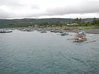
 Fisherfolk at Aplaya
References
- Municipality of Dingalan | (DILG)
- "2015 Census of Population, Report No. 3 – Population, Land Area, and Population Density" (PDF). Philippine Statistics Authority. Quezon City, Philippines. August 2016. ISSN 0117-1453. Archived (PDF) from the original on May 25, 2021. Retrieved July 16, 2021.
- Census of Population (2020). "Region III (Central Luzon)". Total Population by Province, City, Municipality and Barangay. Philippine Statistics Authority. Retrieved 8 July 2021.
- "PSA Releases the 2018 Municipal and City Level Poverty Estimates". Philippine Statistics Authority. 15 December 2021. Retrieved 22 January 2022.
- "Republic Act No. 1536; An Act Creating the Municipal District of Dingalan in the Municipality of Baler, Subprovince of Aurora, Province of Quezon". The Corpus Juris. 16 June 1956. Archived from the original on 6 November 2016. Retrieved 6 November 2016.
- "Republic Act No. 3490; An Act to Convert the Municipal District of Dingalan, Subprovince of Aurora, Province of Quezon, into a Municipality". The Corpus Juris. 16 June 1962. Archived from the original on 6 November 2016. Retrieved 6 November 2016.
- Municipality of Dingalan in aurora.gov.ph
- "Province: Aurora". PSGC Interactive. Quezon City, Philippines: Philippine Statistics Authority. Retrieved 12 November 2016.
- "Municipal: Dingalan". PSGC Interactive. Quezon City, Philippines: Philippine Statistics Authority. Retrieved 8 January 2016.
- Census of Population and Housing (2010). "Region III (Central Luzon)" (PDF). Total Population by Province, City, Municipality and Barangay. National Statistics Office. Retrieved 29 June 2016.
- "Dingalan, Aurora: Average Temperatures and Rainfall". Meteoblue. Retrieved 27 December 2018.
- Census of Population (2015). "Region III (Central Luzon)". Total Population by Province, City, Municipality and Barangay. Philippine Statistics Authority. Retrieved 20 June 2016.
- Censuses of Population (1903–2007). "Region III (Central Luzon)". Table 1. Population Enumerated in Various Censuses by Province/Highly Urbanized City: 1903 to 2007. National Statistics Office.
- "Province of Aurora". Municipality Population Data. Local Water Utilities Administration Research Division. Retrieved 17 December 2016.
- "Poverty incidence (PI):". Philippine Statistics Authority. Retrieved December 28, 2020.
- "Estimation of Local Poverty in the Philippines" (PDF). Philippine Statistics Authority. 29 November 2005.
- "2003 City and Municipal Level Poverty Estimates" (PDF). Philippine Statistics Authority. 23 March 2009.
- "City and Municipal Level Poverty Estimates; 2006 and 2009" (PDF). Philippine Statistics Authority. 3 August 2012.
- "2012 Municipal and City Level Poverty Estimates" (PDF). Philippine Statistics Authority. 31 May 2016.
- "Municipal and City Level Small Area Poverty Estimates; 2009, 2012 and 2015". Philippine Statistics Authority. 10 July 2019.
- "PSA Releases the 2018 Municipal and City Level Poverty Estimates". Philippine Statistics Authority. 15 December 2021. Retrieved 22 January 2022.
External links
- Philippine Standard Geographic Code
- Dingalan on Aurora.ph