Aurora (province)
Aurora, officially the Province of Aurora (Filipino: Lalawigan ng Aurora; Ilocano: Probinsia ti Aurora), is a province in the Philippines located in the eastern part of Central Luzon region, facing the Philippine Sea. Its capital is Baler and borders, clockwise from the south, the provinces of Quezon, Bulacan, Nueva Ecija, Nueva Vizcaya, Quirino, and Isabela.
Aurora | |
|---|---|
| Province of Aurora | |
    (from top: left to right) Dinadiawan Beach in Dipaculao, Ditawini beach in Dinalungan, Cuaresma beach in Casiguran and Dicasalarin Cove in Baler. | |
 Flag  Seal | |
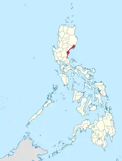 Location in the Philippines | |
OpenStreetMap | |
| Coordinates: 15°53′N 121°33′E | |
| Country | Philippines |
| Region | Central Luzon |
| Founded | 1951 (as sub-province of Quezon) |
| Province | 13 August 1979 |
| Named for | Aurora Quezon |
| Capital | Baler |
| Largest Municipality | Maria Aurora |
| Government | |
| • Governor | Christian M. Noveras (PFP) |
| • Vice Governor | Gerardo Noveras (PDP–Laban) |
| • Legislature | Aurora Provincial Board |
| Area | |
| • Total | 3,147.32 km2 (1,215.19 sq mi) |
| • Rank | 42nd out of 81 |
| Highest elevation (Mount Mingan) | 1,901 m (6,237 ft) |
| Population (2020 census)[2] | |
| • Total | 235,750 |
| • Rank | 70th out of 81 |
| • Density | 75/km2 (190/sq mi) |
| • Rank | 77th out of 81 |
| Demonym | Auroran |
| Divisions | |
| • Independent cities | 0 |
| • Component cities | 0 |
| • Municipalities | |
| • Barangays | 151 |
| • Districts | Legislative district of Aurora |
| Demographics | |
| • Ethnic groups |
|
| • Languages | |
| Time zone | UTC+8 (PST) |
| ZIP code | 3200–3207 |
| IDD : area code | +63 (0)42 |
| ISO 3166 code | PH-AUR |
| Website | www |
Before 1979, Aurora was part of the province of Quezon. Aurora was, in fact, named after Aurora Aragon, the wife of Pres. Manuel L. Quezon, the president of the Philippine Commonwealth, after whom the mother province was named.
History
Spanish colonial era
In 1572, the Spanish explorer Juan de Salcedo became the first European to visit the region that would be known as Aurora while he was exploring the northern coast of Luzon. Salcedo reportedly visited the towns of Casiguran, Baler and Infanta.
In the early days of the Spanish colonial period, Aurora was ecclesiastically linked to Infanta, which today rests further south, in northern Quezon. The earliest missionaries in the province were the Franciscans, who had established missions in Baler and Casiguran in 1609.[3] Due to lack of available personnel, the region was given to the jurisdiction of the Augustinians and Recollects in 1658, but was returned to the Friars Minor in 1703. Other early missions included Dipaculao, established in 1719, and Casiguran, in 1753.
District of El Principe
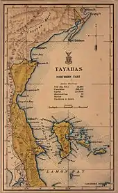
The early history of Aurora is linked to Quezon province, of which it formed a part, and Nueva Ecija, under which the area was governed as the District of El Príncipe. North Aurora was part of Nueva Vizcaya. In 1902, the district was separated from Nueva Ecija and the northern area was separated from Nueva Vizcaya in 1905 and both transferred to the province of Tayabas (now Quezon).[3][4]
Philippine independence
Aurora became a sub-province of Quezon in 1951 through Republic Act No. 648 under the presidency of Elpidio Quirino,[5] after whom its neighboring province was named, and finally became an independent province during the presidency of Ferdinand E. Marcos, through Batas Pambansa Blg. 7 enacted on November 21, 1978.[3][6]
Administrative assignment
As original part of the province of Quezon, Aurora was part of the Southern Tagalog Region (Region IV). Upon the issuance of Executive Order No. 103, dated May 17, 2002, by then-President Gloria Macapagal-Arroyo, the province of Aurora was moved to Central Luzon (Region III), geographical location of the province. The provinces south of Aurora formed as Calabarzon and Mimaropa, and Southern Tagalog was limited to being a cultural-geographic region.
Geography
Aurora is a coastal province covering an area of 3,147.32 square kilometres (1,215.19 sq mi)[7] in east-central Luzon. To the north, it is bordered by the Northern Sierra Madre Natural Park of Isabela, to the west by the central range of the Sierra Madre which contains the Casecnan Protected Landscape and Aurora Memorial National Park, to the south by the Umiray River, and to the east by the Philippine Sea which opens to the Pacific Ocean. The San Ildefonso Peninsula lies in the province's northern portion between the Philippine Sea and the Casiguran Sound.
Topography
The province covers a portion of the Sierra Madre mountain range. As such, the elevation is generally steep to very steep and only about 14% of the province's total area is flat.[3]
Climate
Aurora's climate is classified as Tropical rainforest climate.[8] It experiences significant rainfall throughout the year.[8] Because the coastal province faces the Pacific Ocean, it is frequently visited by typhoons.[3][9]
Administrative divisions
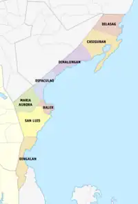
Aurora is politically subdivided into 8 municipalities, all encompassed by a lone legislative district.
| Municipality [lower-roman 1] | Population | ±% p.a. | Area[7] | Density | Barangay | |||||||
|---|---|---|---|---|---|---|---|---|---|---|---|---|
| (2020)[2] | (2015)[10] | km2 | sq mi | /km2 | /sq mi | |||||||
| Baler | † | 18.6% | 43,785 | 39,562 | +1.95% | 92.54 | 35.73 | 470 | 1,200 | 13 | ||
| Casiguran | 11.3% | 26,564 | 24,313 | +1.70% | 715.43 | 276.23 | 37 | 96 | 24 | |||
| Dilasag | 7.3% | 17,102 | 15,835 | +1.48% | 306.25 | 118.24 | 56 | 150 | 11 | |||
| Dinalungan | 5.3% | 12,508 | 11,322 | +1.91% | 316.85 | 122.34 | 39 | 100 | 9 | |||
| Dingalan | 11.8% | 27,878 | 25,482 | +1.73% | 304.55 | 117.59 | 92 | 240 | 11 | |||
| Dipaculao | 14.1% | 33,131 | 29,736 | +2.08% | 361.64 | 139.63 | 92 | 240 | 25 | |||
| Maria Aurora | 19.1% | 44,958 | 40,734 | +1.90% | 426.29 | 164.59 | 110 | 280 | 40 | |||
| San Luis | 12.7% | 29,824 | 27,352 | +1.66% | 609.85 | 235.46 | 49 | 130 | 18 | |||
| Total | 235,750 | 214,336 | +1.83% | 3,133.40 | 1,209.81 | 75 | 190 | 151 | ||||
| † Provincial capital | Municipality | |||||||||||
| ||||||||||||
Demographics
|
|
| ||||||||||||||||||||||||||||||||||||||||||||||||||||||
| Source: Philippine Statistics Authority[10][11][11] | ||||||||||||||||||||||||||||||||||||||||||||||||||||||||
The population of Aurora in the 2020 census was 235,750 people,[2] with a density of 75 inhabitants per square kilometre or 190 inhabitants per square mile.
Based on the 2000 census survey, Tagalogs comprised 52.85% (91,745) of the total provincial population of 173,589, and about less than 1/3 of the population were Ilocano at 31.43% (54,557). Other ethnic groups in the province were Kasiguranin at 5.1% (8,853), Bicolano at 4.08% (7,079), Kankanaey at 1.36% (2,355), Bisaya at 0.88% (1,529), Dumagat (Umiray) at 0.6% (1,047), and Cebuano at 0.48% (832).[12]
There are also pockets of Bugkalots & Negritos, called Dumagats. Most Dumagats are living in the hillsides or mountains. They are believed to have result from a fusion of Austronesian and Melanesian ancestries, and survive from fishing and hunting. There are three kinds of Dumagats in Aurora province, the Umiray Dumagat, Casiguran Dumagat, and the Palanan Dumagat.
Tagalogs, some originating from Palanan and Infanta, Quezon, came in to the area to trade by boat, some Tagalogs settled in Aurora (especially Baler) and married with the Aeta and Bugkalots.[13] The Spanish brought in Filipino acolytes from other areas of Luzon from 1609 to 1899. During this period, Baler can only be access by sea though the town saw increase migration from other parts of Luzon such as Laguna, Tayabas, and Bicol from the south. The opening of the Baler-Bongabon Road allowed easier migration of people from Ilocos and Isabela areas from the north. The road also allowed Igorot people and Batangueño Tagalogs to settle in Baler & other places of Aurora. In 1896, a group of Ilocanos from Aringay, La Union came to settle in San Jose, now called Maria Aurora; in 1906, another group of Ilocanos arrived from La Union and Pangasinan. In the early 1920s, Ilocano settlers from Central Luzon settled a Bugkalot territory Dipaculao, which in turn was derived from the phrase Dipac naulaw or Naulaw ni Dipac, the Ilocano for "Dipac got dizzy", idiomatically "Dipac is/got drunk", Dipac is the name of a Bugkalot chief; another group of Ilocano settlers arrived from La Union, Pangasinan, and other areas of Ilocos Region. The guerrilla movement during the Japanese occupation brought Novo Ecijanos (people from Nueva Ecija) to Baler; Novo Ecijanos include Tagalogs, Ilocanos, and Kapampangans. The Balereños learned trade from the Batangueños and the Novo Ecijanos; where before they used to share what they have, now they would sell coconut to their neighbors.[13]
Languages
The Tagalog and Ilocano languages are spoken by their respective ethnic groups. The province primarily speaks a Tagalog dialect with some Ilocano influences. In Baler, for example, the variety is called Tagalog-Baler (Balereño). The Balereño is also known for distinctive expressions like akkaw, used to express surprise, wonder, disgust, and objection; it is also akin to the English term "Wow!" Other regional term expressions spoken in Baler are are(h), used to express a negative feeling of surprise; anin, used to express regret or pity for a situation; and many other words are also spoken similarly to neighboring Quezon, like adyo, meaning to climb, and puropur, which pertain to rain with gusty wind. Ilocano is mostly spoken in northern areas of the province. The working population is ready in speech in the English language as well as in the Filipino language.[14][15][16][17]
Religion

The people of Aurora are heavily Christianized (large majority being Roman Catholic by 87%) as a result of hundreds of years of Spanish colonization. Some other Christian believers are also present which includes Methodists, Aglipayan Church 2-3%, Baptists, Born Again Christians, Jehovah's Witnesses, Members Church of God International, Iglesia ni Cristo 2% and Seventh-day Adventist while Muslims are also found which presence is traced to migration by some people from some parts of Mindanao. Muslims, Anitists, animists, and atheists are also present in the province.
Economy
Corn crops, rice and other major agricultural crops are grown in Aurora. It has a total of 38, 928 or 13% of provincial Land Area of Agricultural land. It also has 8,945 hectares (22,100 acres) of rice plantation that averages 24,000 metric tons (24,000 long tons; 26,000 short tons) every year.
Aurora Pacific Economic Zone
Casiguran is home to the Aurora Pacific Economic Zone and Freeport Authority or APECO a special economic zone located in this coastal town. Created in 2007 by virtue of Republic Act No. 9490 through the efforts of Sen. Edgardo Angara and his son, Aurora Rep. Sonny Angara, it is expected be a major transshipment hub going to the Pacific region. It aims to boost social, economic and industrial developments in Aurora and nearby provinces by generating jobs for the people, improving the quality of their living conditions, advocating an eco-friendly approach to industrialization and enhancing the potential of the community in productivity.
Gallery
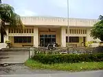 Bulwagan ng Katarungan
(RTC), Suklayin, Baler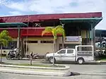 Aurora Police Provincial Office, NPC, PNP, Baler
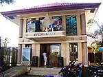 Aurora Provincial Tourism Office (Suklayin)
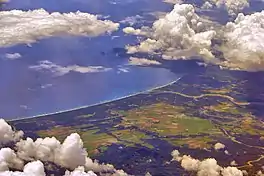
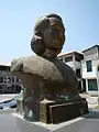 Bust of Maria Aurora
Notable people
- Sonny Angara, senator since 2013.
- Bellaflor Angara-Castillo, governor from 2004 to 2013.
References
- "List of Provinces". PSGC Interactive. Makati, Philippines: National Statistical Coordination Board. Archived from the original on 19 April 2016. Retrieved 5 March 2020.
- Census of Population (2020). "Region III (Central Luzon)". Total Population by Province, City, Municipality and Barangay. Philippine Statistics Authority. Retrieved 8 July 2021.
- Lancion, Jr., Conrado M.; cartography by de Guzman, Rey (1995). "The Provinces; Aurora". Fast Facts about Philippine Provinces (The 2000 Millenium ed.). Makati, Metro Manila, Philippines: Tahanan Books. p. 28. ISBN 971-630-037-9. Retrieved 4 December 2015.
{{cite book}}: CS1 maint: multiple names: authors list (link) - National Historical Commission of the Philippines. "History of Baler". National Historical Commission of the Philippines. Archived from the original on May 14, 2013. Retrieved 2012-03-09.
When military district of El Príncipe was created in 1856, Baler became its capital...On June 12, 1902 a civil government was established, moving the district of El Príncipe away from the administrative jurisdiction of Nueva Ecija...and placing it under the jurisdiction of Tayabas Province.
- Republic Act No. 648 (14 June 1951). An Act Creating the Subprovince of Aurora, Which Shall Comprise the Municipalities of Baler, Casiguran, Dipaculao and Maria Aurora, Province of Quezon. Retrieved 8 December 2015.
- Batas Pambansa Blg. 7 (21 November 1978). An Act Separating the Sub-province of Aurora from the Province of Quezon and Establishing It as an Independent Province. Retrieved 8 December 2015.
- "Province: Aurora (province)". PSGC Interactive. Quezon City, Philippines: Philippine Statistics Authority. Retrieved 8 January 2016.
- "Climate: Aurora". Climate-data.org. Retrieved 8 December 2015.
- Iglesias, Iza; Vargas, Anthony; Cueto, Francis Earl A. (17 October 2015). "3 days of heavy rain". The Manila Times. Retrieved 8 December 2015.
- Census of Population (2015). "Region III (Central Luzon)". Total Population by Province, City, Municipality and Barangay. Philippine Statistics Authority. Retrieved 20 June 2016.
- Census of Population and Housing (2010). "Region III (Central Luzon)" (PDF). Total Population by Province, City, Municipality and Barangay. National Statistics Office. Retrieved 29 June 2016.
- "Aurora: Housing Unit Occupancy Rate Almost 100 Percent; Table 4. Household Population by Ethnicity and Sex: Aurora, 2000". Philippine Statistics Authority. 11 June 2002. Archived from the original on 5 March 2012. Retrieved 26 July 2016.
- Mesina, Ilovita. "Baler And Its People, The Aurorans". Aurora.ph. Retrieved 21 February 2018.
- Aurora: Who We Are in DILG website
- Selaznog, Olag (2013). Ak'kaw Poppo: Talaan ng Salitang Baler (1st ed.). Makati City: Baler Aurora Ngayon Angkan at Kasaysayan (Banak Inc.).
- Batang Baler Ako Website
- OoCities: Batang Baler
- "Poverty incidence (PI):". Philippine Statistics Authority. Retrieved December 28, 2020.
- "Estimation of Local Poverty in the Philippines" (PDF). Philippine Statistics Authority. 29 November 2005.
- "2009 Official Poverty Statistics of the Philippines" (PDF). Philippine Statistics Authority. 8 February 2011.
- "Annual Per Capita Poverty Threshold, Poverty Incidence and Magnitude of Poor Population, by Region and Province: 1991, 2006, 2009, 2012 and 2015". Philippine Statistics Authority. 27 August 2016.
- "Annual Per Capita Poverty Threshold, Poverty Incidence and Magnitude of Poor Population, by Region and Province: 1991, 2006, 2009, 2012 and 2015". Philippine Statistics Authority. 27 August 2016.
- "Annual Per Capita Poverty Threshold, Poverty Incidence and Magnitude of Poor Population, by Region and Province: 1991, 2006, 2009, 2012 and 2015". Philippine Statistics Authority. 27 August 2016.
- "Updated Annual Per Capita Poverty Threshold, Poverty Incidence and Magnitude of Poor Population with Measures of Precision, by Region and Province: 2015 and 2018". Philippine Statistics Authority. 4 June 2020.
External links
 Media related to Aurora at Wikimedia Commons
 Geographic data related to Aurora (province) at OpenStreetMap
Places adjacent to Aurora (province) | |
|---|---|
| Municipalities | |
|---|---|
| Barangays | |
