Gabaldon, Nueva Ecija
Gabaldon, officially the Municipality of Gabaldon (Tagalog: Bayan ng Gabaldon, Ilocano: Ili ti Gabaldon), is a 3rd-class municipality in the province of Nueva Ecija, Philippines. According to the 2020 census, it has a population of 38,958 people.[3]
Gabaldon
Sabani | |
|---|---|
| Municipality of Gabaldon | |
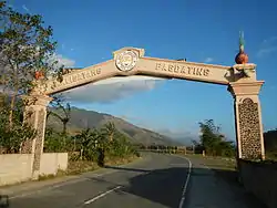
 Welcome Arch | |
 Seal | |
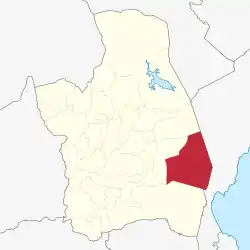
 Map of Nueva Ecija with Gabaldon highlighted | |
OpenStreetMap | |
.svg.png.webp) Gabaldon Location within the Philippines | |
| Coordinates: 15°27′02″N 121°20′16″E | |
| Country | Philippines |
| Region | Central Luzon |
| Province | Nueva Ecija |
| District | 3rd district |
| Named for | Isauro Gabaldón |
| Barangays | 16 (see Barangays) |
| Government | |
| • Type | Sangguniang Bayan |
| • Mayor | Jobby P. Emata |
| • Vice Mayor | Victorino V. Sabino |
| • Representative | Rosanna V. Vergara |
| • Municipal Council | Members |
| • Electorate | 24,564 voters (2022) |
| Area | |
| • Total | 242.88 km2 (93.78 sq mi) |
| Elevation | 339 m (1,112 ft) |
| Highest elevation | 1,389 m (4,557 ft) |
| Lowest elevation | 114 m (374 ft) |
| Population (2020 census)[3] | |
| • Total | 38,958 |
| • Density | 160/km2 (420/sq mi) |
| • Households | 9,881 |
| Economy | |
| • Income class | 3rd municipal income class |
| • Poverty incidence | 7.13 |
| • Revenue | ₱ 157.3 million (2020) |
| • Assets | ₱ 463.5 million (2020) |
| • Expenditure | ₱ 185.5 million (2020) |
| • Liabilities | ₱ 195 million (2020) |
| Service provider | |
| • Electricity | Nueva Ecija 2 Area 2 Electric Cooperative (NEECO 2 A2) |
| Time zone | UTC+8 (PST) |
| ZIP code | 3131 |
| PSGC | |
| IDD : area code | +63 (0)44 |
| Native languages | Tagalog Ilocano |
| Website | gabaldon |
The municipality is located in the valley situated at the footstep of the Sierra Madre to its east and the Caraballo Mountains to its west.[5] It lies 39 kilometres (24 mi) from Palayan and 169 kilometres (105 mi) from Manila. Gabaldon is bounded by the municipalities of Bongabon to the north, Laur to the west, General Tinio to the south, and Dingalan, Aurora to the east.
Etymology
On June 16, 1955, the town's name was changed from Sabani to Gabaldon in honor of the former provincial governor and Philippine Resident Commissioner Isauro Gabaldón.
History
During the latter half of the 19th century, Gabaldon was the site of the Sabani Estate, the largest hacienda in Nueva Ecija, which was then part of Laur. The estate possessed 3,000 heads of cattle and occupied more than 6,000 hectares.[6] On May 10, 1920, the national government, through the National Development Company, took over the administration of the estate and developed it for rice production. A group composed of local businessmen leased the estate until 1935, after which it was returned to Sabani Estate Development Company. The government then converted the estate into a homestead.[7]
On June 12, 1950, the barrios of Bitulok, Bantug, Bitulok Saw Mill, Cuyapa, Macasandal, Pantok, Calumpang, Malinao, Tagumpay, Bugnan, Bagong Sicat, Ligaya, Calabasa, Bateria and Pintong Bagting were separated from Laur to constitute the new municipality of Bitulok.[8]
The municipality's name was changed from Bitulok to Sabani.[9] On June 16, 1955, the municipality's name was changed from Sabani to Gabaldon by virtue of Republic Act 1318, to honor former provincial governor and Philippine Resident Commissioner Isauro Gabaldón.[10]
Geography
Barangays
Gabaldon is politically subdivided into 16 barangays. Each barangay consists of puroks and some have sitios.
- Bagong Sikat
- Bagting
- Bantug
- Bitulok (North Poblacion)
- Bugnan
- Calabasa
- Camachile
- Cuyapa
- Ligaya
- Macasandal
- Malinao
- Pantoc
- Pinamalisan
- South Poblacion
- Sawmill
- Tagumpay
Climate
| Climate data for Gabaldon, Nueva Ecija | |||||||||||||
|---|---|---|---|---|---|---|---|---|---|---|---|---|---|
| Month | Jan | Feb | Mar | Apr | May | Jun | Jul | Aug | Sep | Oct | Nov | Dec | Year |
| Average high °C (°F) | 26 (79) |
27 (81) |
28 (82) |
30 (86) |
30 (86) |
30 (86) |
29 (84) |
29 (84) |
29 (84) |
28 (82) |
27 (81) |
26 (79) |
28 (83) |
| Average low °C (°F) | 19 (66) |
19 (66) |
20 (68) |
22 (72) |
23 (73) |
23 (73) |
23 (73) |
23 (73) |
23 (73) |
22 (72) |
21 (70) |
20 (68) |
22 (71) |
| Average precipitation mm (inches) | 21 (0.8) |
18 (0.7) |
16 (0.6) |
18 (0.7) |
65 (2.6) |
102 (4.0) |
112 (4.4) |
95 (3.7) |
91 (3.6) |
99 (3.9) |
58 (2.3) |
49 (1.9) |
744 (29.2) |
| Average rainy days | 6.8 | 5.2 | 6.1 | 7.1 | 16.1 | 20.2 | 22.6 | 21.6 | 20.9 | 16.0 | 9.0 | 9.3 | 160.9 |
| Source: Meteoblue[11] | |||||||||||||
Demographics
| Year | Pop. | ±% p.a. |
|---|---|---|
| 1960 | 9,907 | — |
| 1970 | 13,865 | +3.41% |
| 1975 | 15,673 | +2.49% |
| 1980 | 17,169 | +1.84% |
| 1990 | 21,744 | +2.39% |
| 1995 | 25,750 | +3.22% |
| 2000 | 28,324 | +2.06% |
| 2007 | 29,619 | +0.62% |
| 2010 | 32,246 | +3.14% |
| 2015 | 35,383 | +1.78% |
| 2020 | 38,958 | +1.91% |
| Source: Philippine Statistics Authority[12][13][14][15] | ||
Economy
Agriculture is the main economic source of the municipality, with 56% of its land area being used for farming. Rice is the primary crop being cultivated in the municipality's lowland while secondary crops such as onion, corn, garlic, ampalaya, and other crops are cultivated in the uplands. The municipality is one of the top onion producers in the province. Limited livestock, poultry, and fish production are also present.[23]
The municipality has nearly 300 commercial establishments mostly centered along the national road and around the municipal public market. Moreover, there are 6 agri-based industrial establishments within the city, including 5 rice mills and a commercial poultry, and 20 cottage industry establishments.[24]
Tourism
Due to Gabaldon's proximity to the coastal town of Dingalan, Aurora and its scenic location in the valley, there are several ecological tourist spots found in the municipality, including the Dupinga Water Reservoir, the Sierra Madre, Cabangcalan Lake, and multiple waterfalls dotting the southeastern part of the Sierra Madre. Numerous resorts are in the municipality, including the Ecopark located inside the Gabaldon campus of the Nueva Ecija University of Science and Technology.[25]
References
- Municipality of Gabaldon | (DILG)
- "2015 Census of Population, Report No. 3 – Population, Land Area, and Population Density" (PDF). Philippine Statistics Authority. Quezon City, Philippines. August 2016. ISSN 0117-1453. Archived (PDF) from the original on May 25, 2021. Retrieved July 16, 2021.
- Census of Population (2020). "Region III (Central Luzon)". Total Population by Province, City, Municipality and Barangay. Philippine Statistics Authority. Retrieved 8 July 2021.
- "PSA Releases the 2018 Municipal and City Level Poverty Estimates". Philippine Statistics Authority. 15 December 2021. Retrieved 22 January 2022.
- "Municipal Profile – Official Website of Municipality of Gabaldon". Retrieved 2019-12-31.
- McCoy; de Jesus. Philippine social history: global trade and local transformations. p. 67.
- "History Of Gabaldon – Official Website of Municipality of Gabaldon". Retrieved 2019-12-31.
- "An Act to Create the Municipality of Bitulok in the Province of Nueva Ecija". LawPH.com. Archived from the original on 2012-07-14. Retrieved 2011-04-12.
- "An Act Changing the Name of the Municipality of Bitulok in the Province of Nueva Ecija to That of Sabani". LawPH.com. Archived from the original on 2012-07-10. Retrieved 2011-04-12.
- "An Act Changing the Name of the Municipality of Sabani, Province of Nueva Ecija, to Gabaldon". LawPH.com. Archived from the original on 2012-07-10. Retrieved 2011-04-12.
- "Gabaldon: Average Temperatures and Rainfall". Meteoblue. Retrieved 4 May 2020.
- Census of Population (2015). "Region III (Central Luzon)". Total Population by Province, City, Municipality and Barangay. Philippine Statistics Authority. Retrieved 20 June 2016.
- Census of Population and Housing (2010). "Region III (Central Luzon)". Total Population by Province, City, Municipality and Barangay. National Statistics Office. Retrieved 29 June 2016.
- Censuses of Population (1903–2007). "Region III (Central Luzon)". Table 1. Population Enumerated in Various Censuses by Province/Highly Urbanized City: 1903 to 2007. National Statistics Office.
- "Province of Nueva Ecija". Municipality Population Data. Local Water Utilities Administration Research Division. Retrieved 17 December 2016.
- "Poverty incidence (PI):". Philippine Statistics Authority. Retrieved December 28, 2020.
- "Estimation of Local Poverty in the Philippines" (PDF). Philippine Statistics Authority. 29 November 2005.
- "2003 City and Municipal Level Poverty Estimates" (PDF). Philippine Statistics Authority. 23 March 2009.
- "City and Municipal Level Poverty Estimates; 2006 and 2009" (PDF). Philippine Statistics Authority. 3 August 2012.
- "2012 Municipal and City Level Poverty Estimates" (PDF). Philippine Statistics Authority. 31 May 2016.
- "Municipal and City Level Small Area Poverty Estimates; 2009, 2012 and 2015". Philippine Statistics Authority. 10 July 2019.
- "PSA Releases the 2018 Municipal and City Level Poverty Estimates". Philippine Statistics Authority. 15 December 2021. Retrieved 22 January 2022.
- "Municipal Profile – Official Website of Municipality of Gabaldon". Retrieved 2019-12-31.
- "Municipal Profile – Official Website of Municipality of Gabaldon". Retrieved 2019-12-31.
- "Municipal Profile – Official Website of Municipality of Gabaldon". Retrieved 2019-12-31.